Cloonkeen House (Kilmacabea)
Houses within 5km of this house
Displaying 13 houses.
Houses within 5km of Cloonkeen House (Kilmacabea)
Displaying 13 houses.
| House name | Description | |
|---|---|---|
| Drombeg House | Drombeg was being leased by Catherine Jones from Lady Carbery's estate at the time of Griffith's Valuation, when it was valued at over £20. The sale notice of April 1852 includes a small lithograph of the house. In 1837 Lewis referred to Drombeg as the seat of Rev.Jonas Travers Jones. Leet refers to it in 1814 as the residence of John Baldwin. The house is still extant and occuped. See the Clonakilty Museum material at www.allaboutireland.ie |
|
| Lakeview (Kilfaughnabeg) | Leased by Martha Raclaud from the Baldwin estate in 1851 when it was valued at £8. It is labelled Lake View on both the First and 25-inch Ordnance survey maps. A house is still extant at this site. | |
| Glandore Lodge | Leased by Richard Adams from the Barry estate at the time of Griffith's Valuation, when it was valued at £14. Lewis refers to it as the seat of R. Adams in 1837. Though a building appears to exist at the site it is not named on the 25-inch Ordnance Survey map of the 1890s. A hotel is marked at the site. | |
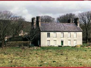
| Derry House (Ross) | Family records indicate the original house at Derry was bought by Bryan Townsend, son of Richard, the Cromwellian officer, in the 1680s. This house was a short distance from the current house which was built by Reverend Horatio Townsend in the early years of the nineteenth century and was held in fee by Reverend Chambre Townsend in 1851 when it was valued at £44. Earlier, in 1786, Wilson referred to Derry as a Townsend seat. It was substantially damaged when it was burnt in April 1921 during the War of Independence. . At the time it was the residence of Alexander Sullivan, a well-known barrister. In 1944 the Irish Tourist Association Survey noted that it was still derelict following the 1921 burning. The centre portion of the house and a substantial farm still exist at the site. |

|
| Roury House | Occupied by William Bleazby at the time of Griffith's Valuation on lease from the Townsend estate and valued at £12 5s. In 1885 Walford refers to the seat of William J. Bleazby as Bleazby Hall. A house still exists at this site. | |
| Cashel House (Kilmacabea) | William Wolfe was leasing this property, then valued at £12, from Miss Wheeler, at the time of Griffith's Valuation. Local records suggest the family were associated with this house since the eighteenth century. The original house is no longer extant and a modern house exists at the site now. | |
| Brook Ville (Kilmacabea) | Leased by John Morris to John Hungerford at the time of Griffith's Valuation, when it was valued at almost £8, Marriage records for the area record it was later the residence of the Wolfe family. On the 25-inch Ordnance Survey map the building at the site is labelled Corran House. The National Inventory of Architectural Heritage describes the property as a miller's house. |

|
| Connonagh House | John Morris was leasing this property to Barbara Jago in 1852 when it was valued at almost £8. There is still an extant house at the site. |
|
| Kilmacabea Mill | John Sheehan was leasing this property from the Bennett estate in 1852, when it was valued at almost £13 and included a mill. A corn mill, then disused, is shown on the 25-inch Ordnance Survey map of the 1890s. A building still exists at the site. | |
| Westwood/Benduff Cottage | Catherine French held this property from William Morris at the time of Griffith's Valuation. On the 25-inch Ordnance Survey map of the 1890s it is labelled Westwood. In 1906 it was owned by Michael French and valued at £13 10s. There is still an extant house at the site. | |
| Castle Salem | This property had formerly belonged to the McCarthys but was acquired by William Morris and re-named Castle Salem. In 1786 Wilson refers to it as the seat of the Morris family but by the publication of the first Ordnance Survey Map it is labelled "Benduff Castle or Castle Salem, in ruins". This property, developed over several centuries, is still extant and occupied. |
|
| Ballynagornagh House | In 1786 Wilson refers to "O'Barley-Hill" as a seat of Mr. Morris. At the time of the publication of the 1st Ordnance Survey the original Ballynagornagh House is described as "in ruins". However, a house has been restored on the site by the 1890s when it appears on the 25-inch Map. At the time of Griffith's Valuation, the townland was still in the possession of the Morris family though much of it was leased to the Donovans. The house was valued at £4 5s. A substantial farm occupies the site now. | |
| Cellmount House | Wilson, writing in 1786, refers to "Selmount House" as a seat of Mr. Morris, three miles from Ross Carbery. This property is labelled "Cellmount House, in ruins" on the 1st edition Ordnance Survey map and there is no trace of it on later maps. |