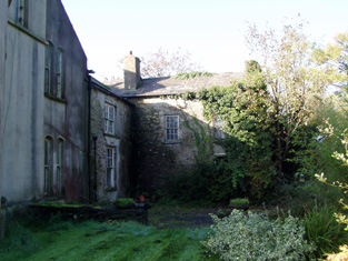
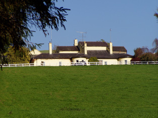
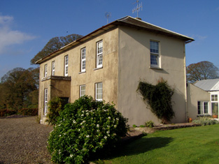
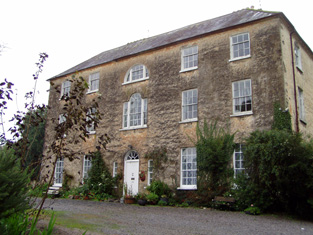
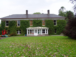
Thornhill
Houses within 5km of this house
Displaying 19 houses.
Houses within 5km of Thornhill
Displaying 19 houses.
| House name | Description | |
|---|---|---|
| Aghern/Ahern House | Brabazon Esq was resident in the 1770s and 1780s. The home of Spotswood Bowles in the first half of the 19th century. The buildings were valued at £47+ in the early 1850s and held from the representatives of William Beamish. Spotswood died in 1864 and was succeeded by his son George who was in turn succeeded by his nephew Spotswood in 1886. Relatives of the Bowles owned this property until the 1970s. In 1942 the Irish Tourist Association Survey mentions the ruins of Aghern Castle in the grounds of Mrs. Spotswood Bowles property. Aghern was uninhabited for a time but has recently been restored. |

|
| Ballyglass/Ballyclough House | At the time of Griffith's Valuation Michael Cagney owned a house in the townland of Kilmagner valued at £24. Ballyglass House is marked on the first Ordnance Survey map in this townland. but the house at this location is named Ballyclough House on the 25-inch Ordnance map of the 1890s. Hajba identifies this house as Ballyclough House, Currabeha. Ballyclough was the residence of E. Creed in 1837. A house still exists at this location. | |
| Moydilliga/Modeligo | In the mid 19th century this house was the home of Henry Braddell. It was valued at £16 and held by him in perpetuity. Wilson, writing in 1786, refers to it as the seat of Mr. Armstead. By 1906 the mansion house at Moydilliga was valued at £42 and occupied by Henry Braddell. In the early 20th century the property passed to the Haskins-Braddells. Sold by them in 1950, this house is still a family home. |
|
| Ballyrobert | Hajba writes that Michael Mackay built a house beside the ruined castle of Ballyrobert in the 1820s and he is recorded as resident there by Lewis in 1837. In the early 1850s the house was valued at £23, occupied by Michael Mackay and held from John Peard. Michael J. Mackey occupied the house in 1906. This house no longer exists. | |
| Belvidere | This house was unoccupied in 1814. Mrs Maria Peard was the occupier in the mid 19th century holding the property from Henry Peard, it was valued at £15.12 shillings. Hajba writes that the Peards sold the estate to the Pope family who occupied the house until the early 20th century. |
|
| Carrigeen Hall | In 1786, Wilson refers to "Carrygeen" as the seat of Mr. Peard. Hajba writes that this house was the home of Peard Harrison Peard, son of Richard Peard of Coole Abbey and father of Richard Frederick Peard of Belvidere and Henry Peard of Carrigeen. Later the home of the Green and O'Grady families, now demolished. | |
| Sun Lodge | Sun Lodge is marked on the first Ordnance Survey map and was occupied by Denis Hanan in the mid 19th century and held from Henry Peard. It was valued at £30+. Hanan's interest was advertised for sale in 1870. Hajba records various other occupants and this house is still occupied and well maintained. |
|
| Castleview | Castleview was the home of the Gumbleton family held from Henry Peard in the mid 19th century and valued at £68.15 shillings. The house remained in Gumbleton possession until the early 20th century but is now demolished. Bence Jones lists this house under the name Glynnatore and writes that it was built in 1791 by R. W. Gumbleton. In 1894 Slater notes Glenatore as the seat of Mrs. Gumbleton. | |
| Waterpark | Originally a Pyne residence which later passed through marriage to the Cavendishes. In 1786 Wlson refers to "the ruins of Water Park, the seat of the late Lord Chief Justice Pine". Hajba writes that other occupants were the Watkins and Drew families. There was no house of more than £2.10 shillings valuation in this townland, held by George Walker, at the time of Griffith's Valuation. | |
| Rathbarry Cottage | Rathbarry Cottage was occupied by Major William Love Peard at the time of Griffith's Valuation. The property was held from the Reverend R. Gumbleton and the buildings were valued at £11. Some ruined walls remain at the site. | |
| Towermore | The home of Mrs Maria Oliver in 1837 but leased to Frederick C. Hayes in the early 1850s. The house was valued at £45. Maria was the widow of Charles S. Oliver of Inchera and a daughter of A. Morris of Dunkettle. A. Morris Oliver is recorded as a subscriber to Lewis ''Topographical Dictionary'' published in 1837 but is not mentioned in Burkes. Earlier, in 1786, Wilson refers to Tormore as the seat of Mr. Connor. This house was not occupied at the end of the 20th century although still extant. | |
| Bride Park | Hajba writes that the Reverend Stephen Rolleston built this house in the 1770s. In 1814 it was inhabited by the Reverend Spread and in the mid 19th century by Thomas Power who held it from Mrs Elina Greaves and others. The buildings were valued at £20+. Bride Park remained the home of the Power family until the early 20th century. This house has recently been renovated and restored. |

|
| Carrigmore | Richard Power was resident here in 1814 and Edward Morragh in the mid 19th century. Morragh held the property from the Duke of Devonshire and the buildings were valued at £18+. Later the home of the Cronin family. Hajba writes that this house has been unoccupied since 1990. | |
| Killavarilly | At the time of Griffith's Valuation John O'Neill, a doctor, held a house valued at £25+ and 350 acres from the Duke of Devonshire at Killavarilly. A house is still located at this site. | |
| Lisnabrin | A 3 storey 18th century house built by the Crokers on property inherited through marriage with the Coppingers in the 17th century. In the mid 19th century occupied by Edward Croker junior, son of Walter, the house was valued at £33+ in the early 1850s. Edward Croker died in 1901and Letitia C.C. Croker is recorded as the occupier in 1906. The property later passed to a relative Captain Walter A. Carew. The house was a hotel for a short time in the mid 20th century but is once more a family home. |
|
| Mogeely House | A house on the Devonshire estate, occupied by Charles H. Walsh in the mid 19th century and valued at £25.18 shillings. Later the home of the Des Barres and Kent families. Slater refers to it as the seat of Lt-Col. Des Barres in 1894. Still a family residence. It is labelled Mogeely Castle on the 1st edition Ordnance Survey map but as Mogeely House on the later editions, |
|
| Lisnabrin Lodge | Occupied by Thomas Carew in 1837 and by Sands Bellis who held the house and 28 acres from Thomas Carew in the mid 19th century. The buildings were valued at £36+. This house is extant, occupied and well maintained. |
|
| Frankfort | This was a Woodley home, occupied by F. Woodley in 1837 and leased to Robert Wigmore in the early 1850s when the house was valued at £20+. The house was occupied until the 1970s but is now a ruin. |

|
| Woodview | Woodview was the home of the Reverend George Nason in 1837 and in the early 1850s was occupied by his son Charles Nason who held the property from Major Edward Croker [Lisfinny]. The buildings were valued at £13+. This house is still a family residence. |