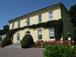
Elm Park
Houses within 5km of this house
Displaying 17 houses.
Houses within 5km of Elm Park
Displaying 17 houses.
| House name | Description | |
|---|---|---|
| Grange (Athnowen) | Smith records Mr Onesiphorus Phaire as resident at Grange, Ovens, in 1750. Wilson, writing in 1786, refers to it as the seat of Mr. Whyte. This house was the home of the Hawkes family in the 19th century, occupied by J. Hawkes in 1814 and 1837 and by John Hawkes in the early 1850s, when the house was valued at £12 and held from Sir John Walsh. A house is still extant at the site. | |
| Aglish | The Hingstons were resident at Aglish from the early 18th century. At the time of Griffith's Valuation James Hingston owned a house valued at £21 in fee. An "old mansion house" is marked on the first Ordnance Survey map at the Grid Reference W469715. The current Aglish House was built after that and appears on the 25-inch map of the 1890s. It is still extant. | |
| Fort William [Kinalea] | Charles L. Bernard held Fort William in fee at the time of Griffith's Valuation, when it was valued at almost £9. Lewis refers to it as the seat of William Penrose in 1837. Buildings remain at the site. | |
| Farran | This house was owned by Samuel Penrose at the time of Griffith's Valuation when it was valued at £24. It was also occupied by him in 1837. In 1868 Farran was bought by William Clarke and three generations of the Clarke family lived at Farran until 1970. In 1906 the buildings were valued at £226 and Thomas Clarke was the occupier. The Irish Tourist Association Survey in the 1940s describes it as "the splendid residence of Captain Clarke, living in the Channel Islands but occupied by his relatives". The present owners offer self catering accommodation for groups. see http://www.farranhouse.com/history.htm |

|
| Rosemount | A house occupied by S. Penrose in 1814, by W. Hawkes in 1837 and Joseph R. Harding at the time of Griffith's Valuation. He held the property from John L. Westropp and the buildings were valued at £25. There is still an extant house at the site. |
|
| Kilcrea House | In 1750 Smith wrote that Kilcrea was formerly the seat of the Earls of Clancarty, purchased by Captain Hedges from the Trustees of the Hollow Blade Company. In 1786 Wilson mentions the ruins of the castle and abbey of Kilcrea, near to which was a house named Snugborough, the residence of Mr. Keeffe. At the time of Griffith's Valuation Robert Gibbons was the occupier of Kilcrea House. He held the house valued at £20 from John Hawkes [who was leasing from Richard T. Rye]. This house is now a ruin. In March 1851 and July 1853 the estate of William Edward Ellis at Kilcrea, Desart, including Kilcrea House and 422 acres was advertised for sale. It was held on a lease dated 1740 Jonathan Ashe to Jeremiah Sullivan. William E. Ellis was the tenant of the house in 1853. William Sullivan Ellis of Kilcrea was issued with a certificate with respect to the killing of game in 1799 (see "The New Cork Evening Post" 24 March 1800). | |
| Cronody | In the mid 18th century Smith refers to the seat and improvements of Mr Cross at Coronody. At the time of Griffith's Valuation James Cross occupied a house valued at £10.10 shillings which he held from Viscount Midleton and John H. Colthurst. This would appear to be the house marked Crondybeg on the first Ordnance Survey map. Cronodymore was in ruins. Gillman writes that Cronodymore was inherited from Richard Hawes by the late 17th century marriage of Philip Cross to Mary Ellard, step daughter of Richard Hawes. A house and farm building are still extant at the site. | |
| Aherla Cottage | A residence valued at £11 and held by William Good in fee at the time of Griffith's Valuation. | |
| Lirias | Mrs Ellard was resident at this house in 1837 and in the early 1850s it was occupied by Benjamin Barter who held it from Sophia Ellard. It was valued at £20. The house shown as Lirias on the 1st edition Ordnance Survey map is not visible on the later 25-inch map of the 1890s though a nearby group of buildings has the same name. Some of these now form part of a farmyard complex. | |
| Aherla | Occupied by the Reverend John Madras at the time of Griffith's Valuation and held from Richard Goode, the buildings were valued at £11.10 shillings. | |
| Springmount | In 1837 and at the time of Griffith's Valuation this property was occupied by Samuel McCarthy. Valued at £19.10 shillings it was held from Lady Carbery's estate. There is still an extant house at the site. | |
| Clashanure | Home of a number of generations of the Allen family in the 18th and 19th centuries. Occupied by the representatives of Kyrle Allen at the time of Griffith's Valuation and held from Robert Meade. The buildings were valued at £15 and the Allens also had a mill valued at £13. Still extant and occupied. |
|
| Surmount/Sirmount | Sirmount was the residence of Emmanuel Moor in 1750. In 1786 Wilson refers to it as the seat of Mr. Hawkes. This house was occupied by G. Hawkes in 1837 and by Quaile Hawkes in the early 1850s. The property was held from Lady Carbery. The buildings were valued at £8.15 shillings. It is no longer extant. | |
| Bride View | Occupied by Samuel Hawkes and held from the representatives of William Hawkes at the time of Griffith's Valuation. The buildings were valued at £13.10 shillings. The property at this location is labelled Knockanemore House on the 25-inch Ordnance Survey map of the 1890s. There is still an extant house at the site. | |
| Inishleena | Located on the Devonshire estate, Inishlenna Abbey was occupied by Cross Fitzgibbon at the time of Griffith's Valuation and in the 1870s. The buildings were valued at £10. The location of the Abbey is now under water as part of a reservoir. | |
| Kilcrea House Upper | At the time of Griffith's Valuation, Corliss Hawkes held a house in Kilcrea townland valued at almost £10. This property is labelled Kilcrea House (Upper) on both the 1st and 25-inch edition Ordnance Survey Maps. A building still exists at the site. | |
| Dripsey Lodge | At the time of Griffith's Valuation this property was occupied by Alfred Greer, leasing from Sir William Magny. The house was valued at £26 while the adjacent paper mills had a valuation of £120. It is named as Dripsey House on the 25-inch Ordnance Survey map of the 1890s. The house is no longer extant. |