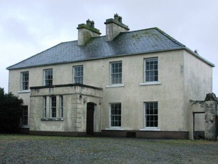
Binghamstown House
Houses within 5km of this house
Displaying 7 houses.
Houses within 5km of Binghamstown House
Displaying 7 houses.
| House name | Description | |
|---|---|---|
| Bingham Lodge | The main residence of this branch of the Bingham family located beside the sea. It is labelled as Bingham Lodge on the 1st edition Ordnance Survey map and a much enlarged building is thus labelled on the 25-inch map of the 1890s. It was in the possession of Henry Bingham at the time of Griffith's Valuation when it was valued at £10 10s. Remains of the walled garden can still be seen at the site. | |
| Curraghboy | This house, valued at £9, was held by Arthur Bingham at the time of Griffith's Valuation and was unoccupied. The original buildings are not shown on the 25-inch Ordnance Survey map of the 1890s. | |
| Shaen Manor or Lodge | The residence of the Carter family or their agent, built on the site of the old glebe house at Logmore. Occupied at the time of Griffith's Valuation by John Crampton. The house was leased in 1877 to Gerald Henry Bingham and with 56 acres was offered for sale in the Landed Estates' Court in 1885. It is named on the 25-inch Ordnance survey map of the 1890s as Logmore House. The site is now a school. | |
| Carn | Described in the Ordnance Survey Name Books as "a good modern slated 2 storied house". It was valued at £2.10s. at the time of Griffith's Valuation and occupied by Thomas Reilly who held it in fee. It is still extant and has been offered for sale in recent years. |

|
| Barranagh House | A house close to the sea on the Mullet peninsular. It was held in fee by John W.O. Richards at the time of Griffith's Valuation when it was valued at £7. A house and farm buildings are still extant at the site. | |
| Tallagh Cottage | At the time of Griffith's Valuation the house was occupied by Anthony Wood, who held it from Andrew Caldwell. It is labelled Tallagh Cottage on the 25-inch edition Ordnance Survey map of the 1890s. This house is no longer extant. | |
| Leam | The residence of Mrs Nash in 1814. Described as a two-storey thatched cottage at the time of the first Ordnance Survey and inhabited by a farmer. At the time of Griffith's Valuation the townland was in the possession of Maria and Letitia Bingham but there is no house with a sutstantial valuation. Some farm building remain at the site. |

