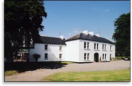
Bruree House
Houses within 5km of this house
Displaying 10 houses.
Houses within 5km of Bruree House
Displaying 10 houses.
| House name | Description | |
|---|---|---|
| Garrane | A house located on the Wyse Minors estate in the mid 19th century, occupied by Margaret Hartigan and valued at £11+. This house is barely marked on the first Ordnance Survey map. | |
| Bruree Lodge | Bruree was the home of the Langton family in the 18th century. The house was occupied by Michael Ryan at the time of Griffith's Valuation and held from Michael Shaughnessy, it was valued at £13+. |
|
| Coolboy | A herd's house and offices situated on the St Leger estate was occupied by Henry Ievers at the time of Griffith's Valuation when the buildings were valued at £14+. Coolboy was occupied by the representatives of Robert Cleary in 1906. A substantial farm is still extant at the site. | |
| Cooleen | At the time of Griffith's Valuation William Hart Mason held the townland of Cooleen amounting to 88 acres in fee. The buildings were valued at £12. |
|
| Clogher West | A house occupied by John Fitzgerald and held from George Whitelock at the time of Griffith's Valuation. The buildings were valued at £12. The original house does not appear to be extant. | |
| Maidstown Castle | Originally known as Ballyvenoge, Seoighe writes that John Ormsby first lived at Maidstown which he sold to the Webbs when he went to live at Athlacca. By the mid 18th century the Webbs had sold Maidstown to the Gubbins. The home of a branch of the Gubbins family in the late 18th century and early 19th century. The house was valued at £20 and held by Patrick Coll from John White in the mid 19th century. The Colls sold Maidstown to the O'Regans in 1972. A house is still extant at the site as well as the ruin of the original tower house. | |
| Creggane Castle | A property associated with the Hutchins family, occupied by John Quaid at the time of Griffith's Valuation and held from Samuel Hutchins. The buildings were valued at £17. The sale rental 1857 records that the original lease dated 1802 was from Edmund Earl of Cork and Orrery to Emanuel Hutchins. Farm buildings occupy the site. | |
| Harding Grove | Occupied by G. Harding in 1814 and H. Harding in 1837. The seat of Mr Harding at the time of the first Ordnance Survey. By the time of Griffith's Valuation a Neill McDonald was in possession of Harding Grove. Neil Macdonald of Steyle Park, Bruree owned 354 acres in county Limerick in the 1870s. Francis H. Wyse is recorded as the occupant of Harding Grove in 1906. |

|
| Athlacca House | A residence of the Ormsby family in the 18th century. On the first Ordnance Survey map the house is marked "in ruins". Also known as Old Court. | |
| Ballyteige | Originally the home of a branch of the Tuthill family, no large house is marked on the first Ordnance Survey map in this townland. The house was leased to David Conyers of Castletown Conyers in 1885 and to Thomas W. Westropp Bennett in the 1890s. It is now available for hire, see http://www.ballyteigue.com/ |
|