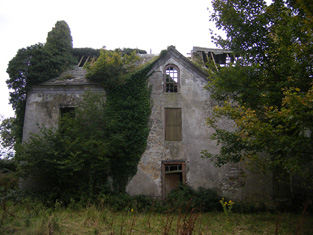
Old Abbey
Houses within 5km of this house
Displaying 10 houses.
Houses within 5km of Old Abbey
Displaying 10 houses.
| House name | Description | |
|---|---|---|
| Fort Anne | The residence of S. E. Johnson in 1837, built by his father William. The house was occupied by Richard Johnston in the early 1850s who held the it from the Reverend R. Dickson, who held the demesne in fee. In 1906 this house valued at £13.15 shillings was occupied by William D. Dickson. The original house is no longer extant. | |
| Ballysteen | Inhabited by James Massey in the early 1850s who held the property from the Earl of Clare. The house was valued at £11+ at that time. Though still extant it has fallen into disuse. |

|
| Movena | A house on the Roche estate occupied by Bridget Farrell in the early 1850s when the buildings were valued at £11. Movena is marked on the first edition Ordnance Survey map. It is now a ruin. |

|
| Waterpark House | A house on the Monteagle estate, the residence of Catherine Nolan in the early 1850s, when it was valued at £10. It is labelled as Waterpark House on the 25-inch Ordnance Survey map of the 1890s. A house is still extant at the site. | |
| Corgrig House | Gerald Griffin was the proprietor of Corgrig in 1826, Mrs Griffin occupied Congrieff in 1837 and Gerald Griffin held Corgrig from Lord Monteagle in the early 1850s. The Ordnance Field Name Books state that Peter Griffin was the proprietor circa 1840 and that his father had erected this house about 80 years previously. It is still extant though with modern housing now occupying much of the surrounding area. The 25-inch Ordnance Survey map of the 1890s also shows a house known as Corgrig Lodge in the same townland at R253511. | |
| Shanagolden House | According to the Ordnance Field Name Books this house was erected in 1812 on the site of a former house. This three-storied house was situated on the Monteagle estate and was occupied by John Griffin in 1814 and by the Reverend George Vincent, rector of Shanagolden in 1837. His son Arthur Vincent was resident in the early 1850s when the house was valued at £20 and in the 1870s when he is recorded as owning 267 acres in county Limerick. It is no longer extant. | |
| Kilcosgrave | Occupied by Danie Sheahan in 1814. The Ordnance Survey Field Name Book states that Kilcosgrave House was built on the site of the Castle and was formerly the residence of the Langford family. It was then a ruin except for one part which had been converted into a farm house. The name of this house is usually spelt Kilcosgriff. | |
| Ballycullen House | This house was built in 1740 by Carrol Naish on the foundation of Ballycullen Castle according to the Ordnance Survey Name Book. Occupied by Patrick C. Nash in 1814 and by Carroll Nash at the time of Griffith's Valuation, it was held from Henry Hare and valued at £14. It is still extant and was restored during the twentieth century. | |
| Ballyclogh | A house on the Monteagle estate, leased to John Copley for ever. The house was 3 storeys high and had been repaired in 1810 by Copley. His representatives were subletting the house to Patrick Griffin by the time of Griffith's Valuation when the buildings were valued at £32. This house is now a ruin. |

|
| Betty Ville House | This house is marked on the first edition Ordnance Survey map. Located on the Blakiston estate, it was occupied by John Shaughnessy in the mid 19th century and held from the Messrs Young. It was valued at £5. |

|

