Woodlands or Aghana
Houses within 5km of this house
Displaying 9 houses.
Houses within 5km of Woodlands or Aghana
Displaying 9 houses.
| House name | Description | |
|---|---|---|
| Pyrmont House | Wilson refers to "Fyrmont" as the seat of George Leake in 1786. In 1837 Lewis recorded this house as the seat of W. Sandes. At the time of Griffith's Valuation, the representatives of Lord Hallyburton's estate were leasing this property to William Sandes, whom Bary describes as the most "fair-minded" of the Sandes family and a noted horseman. The house was valued at £13 10s at the time. Prymount was included in the sale of the Gun Mahony estate in 1856 when William Sandes was recorded as the tenant from year to year. It later passed to the Sandes of Swallowglen and was subsequently demolished. | |
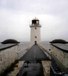
| Tarbert Lighthouse & Keepers House | At the time of Griffith's Valuation, Robert Leslie was leasing this property to the Board of Ordnance, when it included the lighthouse and lightkeeper's house and associated buildings, valued at £22. The lighthouse is still extant and operational. |
|
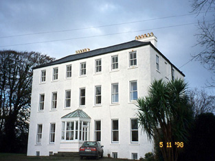
| Tarbert House | Tarbert House was owned by Robert Leslie at the time of Griffith's Valuation when it was valued at £24 10s. Both Leet in 1814 and Lewis, in 1837, note it as the seat of R. Leslie. In 1906 it was valued at £25. The National Inventory of Architectural Heritage suggests the house was built c.1720. In 1786 Wilson describes it as "happily situated on an eminence commanding an extensive view". The house has remained in the Leslie family since that time though the estate was sold to the tenants c.1904. It is open to the public during the summer months. |
|
| Sallowglen | William Sandes was leasing this property to Thomas Sandes at the time of Griffith's Valuation, when it was valued at £24. Lewis notes it as the seat of T.W. Sandes in 1837 as does Leet in 1814. Wilson, writing in 1786, refers to "Sallow Glin, the new and handsome house of William Sandes". In 1906 it was the property of Thomas W. Sandes and valued at £50. Bary writes that it was resided in by the Sandes family and their descendents until the 1920s when the estate was sold. It has since been demolished. | |
| Leslie Lodge or Shanaway | Pierce Mahony was leasing this property to James Patterson at the time of Griffith's Valuation, when it was valued at £12. Wilson refers to it as a seat of Robert Leslie in 1786. In 1814 Leet refers to Leslie Lodge as the residence of John Parker. Lewis, in 1837, records the purchase of the property by Col. D.G. Halliburton In 1856, it is included in the sale of the estate of George Phillip Gun Mahony, a minor, when it is described as untenanted. In 1906, Stephen Collis owned a property at Shanaway East, valued at £6. It is no longer extant. | |
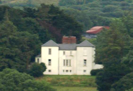
| Tieraclea Lodge | At the time of Griffith's Valuation, Tieraclea was occupied by Stephen Collis, when it was valued at £42. An extensive farmyard is recorded here on the First Edition Ordnance Survey map. The house is labelled as Tieraclea on the later 25-inch map and by 1906 Tieraclea was valued at £45. Bary writes that it had been a residence of the Collis family since the eighteenth century and they continued there until the 1920s. In the early years of the twentieth century the house was destroyed by fire but was re-built and is still extant. | |
| Farranawana House | At the time of Griffith's Valuation, this property was being leased by St. John Blacker to the trustees of Glin Poor Law Union, as an auxilliary workhouse. By 1895 it is labelled on the Ordnance Survey map as Farrawanna House. A house and farm buildings are still extant at the site. | |
| Ballydonohoe | A property held by a junior branch of the Fitzgerald family. The house was the residence of John Church in 1814, Thomas Fitzgerald in 1837 and of St John Thomas Blacker in the early 1850s. It was valued at £13 at that time. |
|
| Shannon View (Tarbert) | At the time of Griffith's Valuation, Richard Hinde held a farmhouse at Coolnanoonagh, valued at £2 15s. A house labelled Shannon View appears at this location on the 25-inch edition Ordnance Survey map, published in the 1890s. A house is still extant at the site. |