Lismore
Houses within 5km of this house
Displaying 13 houses.
Houses within 5km of Lismore
Displaying 13 houses.
| House name | Description | |
|---|---|---|
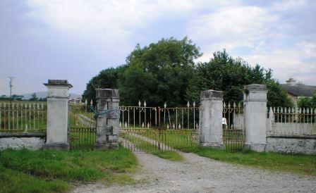
| Chute Hall | Richard Chute was occupying Chute Hall at the time of Griffith's Valuation, when it was valued at £37 10s. Lewis also records it as his residence in 1837. The house is named "Tullygarran House" on the 1st edition of the Ordnance Survey map and is so described in the Ordnance Survey Name Books where it is noted it was "three stories high and about a century old". The house later became known as Chute Hall. Bary notes that the Chutes had been resident in this area since the seventeenth century on what had been McElligott land. In 1894 it was the residence of Mrs. Chute. Richard, the last of the Chutes to live here, died in 1936. In 1943 the Irish Tourist Association Survey noted Chute Hall "now almost a wreck but once a fine imposing structure." The house has been demolished but the substantial gateway remains inside which are some fine ogham stones. |
|
| Spring Hill | Richard Chute was leasing Spring Hill to Penelope Chute at the time of Griffith's Valuation, when it was valued at £23. Bary notes that Richard Chute enlarged and extended an existing house here in 1816. Lewis records the house as the seat of Captain Chute in 1837. The Ordnance Survey Name Books note that the original house was thatched but the house existing in the 1830s was "two stories high and neatly built". In the later nineteenth century, the Linden family, agents to the Chutes occupied Spring Hill and remained into the twentieth century. It is now ruined and overgrown. |
|
| Kilquane | Charles Blennerhassett was leasing this property to Thomas Rooney at the time of Griffith's Valuation, when it was valued at £3, on a farm of 130 acres. This may be the property to which Wilson refers as the seat of William Blennerhasset in 1786 which he names Elm-Grove. A substantial farm is extant at the site. | |
| Ashgrove Mill | John Busteed and Arthur Rowan were the lessors of a house and mill at Tonreagh, vacant at the time of Griffith's Valuation, when the complex was valued at £25 15s. | |
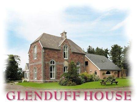
| Glenduff House | Robert Conway Hurley was leaing this property to John Hurley at the time of Griffith's Valuation, when it was valued at £5 15s. In 1906 it was the property of John C. Hurley and valued at £10 15s. Bary writes that the Hurley family owned Bridge House in Tralee but also retained Glenduff House as their country estate. The house remained in the Hurley family until it was sold in the early twentieth century. It has been extensively renovated and is now a guesthouse. |
|
| Doon House | At the time of Griffith's Valuation, William M. Hickson was in possession of this property, then valued at £9 15s. | |
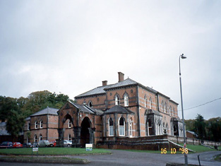
| Oakpark or Collis-Sandes House | Maurice Sandes was in possession of this property at the time of Griffith's Valuation, when it was valued at £60. It is labelled as Oakpark on the 1st edition Ordnance Survey Map. In 1837 Lewis recorded Oakpark as the seat of John Bateman. Bary writes that, Killeen, the original house at this site, was a late seventeenth century house. It was followed by Oakpark, built by John Bateman in the 1820s. This is the house mentioned by Wilson in 1786 as the seat of Rowland Bateman. Maurice Sandes purchased the estate in the late 1840s and built the later Oakpark House c.1857. In 1906 this house was owned by Falkiner Sandes and valued at £112. The house was sold in 1922 and is now used as offices. |
|
| Ballinorig House | At the time of Griffith's Valuation, Colthurst Bateman was leasing this property to Jonathon Walpole when it was valued at £14. The building is not labelled on the Ordnance Survey maps though a more substantial house exists at the site on the later 25-inch edition. Burke records that Colthurst Bateman resided in, and was, High Sheriff of Monmouth, in 1839. Ballinorig House is still extant. | |
| Ann's Villa [Oak Villa] | Thomas Payne was leasing this property from Sir Edward Denny's estate at the time of Griffith's Valuation, when it was valued at £30. The house is labelled Ann's Villa on the 1st edition Ordnance Survey map. A more substantial building, known as Oak Villa, appears on the 25-inch edition of the 1890s. Buildings are still extant at the site. | |
| Lee Brook | Francis Raymond was leasing this property to Richard Roland Chute at the time of Griffith's Valuation when it was valued at £30. In 1906 it was owned by Rowland Chute and valued at £30. Bary states that this house was associated with the Chute family and may have been built by them in the eighteenth century. It remained in the family until the 1930s and is still extant and occupied. The 25-inch edition Ordnance Survey map indicates an additional house in the townland, labelled Lee Brook House. A much enlarged version of this building now serves as Ballygarry House Hotel [Q866134]. | |
| Mount Hawk | In 1906 Mounthawk was owned by Elizabeth Stokes and valued at £18 5s. The townland was in the possession of George Stokes at the time of Griffith's Valuation. Bary states that it was built by George Stokes on lands purchased from the McCarthy family and remained in the Stokes family well into the twentieth century. It was later used as a clubhouse by Tralee Golf Club. | |
| Tralee | At the time of Griffith's Valuation, Francis Crumpe was leasing a property, valued at £31, at Denny St., Tralee, from John Donovan. [Grid Reference is approximate]. | |
| Tralee Castle | In 1786 Wilson writes "at Tralee is a castle in tolerable preservation, formerly one of the castles of the Earls of Desmond, granted by Queen Elizabeth to Sir Anthony Denny, and now the seat of his descendent, Sir Barry Denny". In 1943 the Irish Tourist Association Survey mentions that the last reconstruction of the building occurred in 1802. Bary writes that, after the Act of Union, the Denny family spent more time in England and the castle fell out of use and was eventually demolished and the stones used for other buildings. |