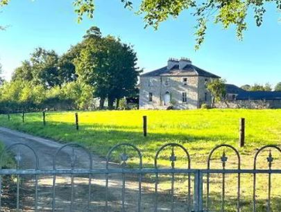
Brook Lodge
Houses within 10km of this house
Displaying 43 houses.
Houses within 10km of Brook Lodge
Displaying 43 houses.
| House name | Description | |
|---|---|---|
| Emlaghkeadew | At the time of Griffith's Valuation this house was ccupied by Louis Ormsby when it was valued at almost £10. It is no longer extant and a modern house exists at the site now. | |
| Mount Prospect | This house was the residence of John Browne in 1814. Recorded as the seat of Mr Fallon at the time of the first Ordnance Survey in the 1830s but in ruins by the mid 1850s. though a small portion of the house is labelled Mount Prospect on the 25-inch Ordnance Survey map of the 1890s. Small fragments of the building remain at the site. | |
| Bohagh Lodge | At the time of Griffith's Valuation, Robert Glancey was leasing a house valued at £6 and over 500 acres at Bohagh, barony of Castlereagh from Travers R. Blackley. | |
| Ballaghawbeg | Richard Irwin's estate owned a herd's house valued at £2 together with over 400 acres at Ballaghawbeg, barony of Castlereagh, at the time of Griffith's Valuation. The Census of Elphin in 1749 recorded that Charles O'Conor, farmer, held this property at the time. Some ruins exist at the site. | |
| Emlagh | Robert Irwin was leasing a property valued at £5 + 230 acres at Emlagh, barony of Castlerea, to Patrick Flynn, at the time of Griffith's Valuation. The Census of Elphin indicates that John Irwin resided there in 1749. Gormley states that the house was probably built around 1740 and extended in the early 1800s. By the 1880s the Irwins had sold Emlagh to Walter McDermott. The house was later demolished. | |
| Milltown | Roderick O'Conor/O'Connor occupied the property at Milltown, barony of Castlerea, valued at £36, at the time of Griffith's Valuation. It was also recorded as his seat in both 1814 and 1837. Gormley states that nothing of the house now remains save for traces of the mile long avenue. | |
| Heathfield | Patrick Balfe was leasing the property at Heathfield, valued at £36, to John Butler at the time of Griffith's Valuation. Lewis records Heathfield as the seat of Nicholas Balfe. It was also his seat in 1814. Gormley states that this house was originally known as Belgard Lodge and was part of the estate of Thomas Dillon of Belgard Castle, county Dublin. Richard Irwin of Fernhall acted as his agent in Roscommon. By 1830 the Heathfield estate was owned by Patrick Balfe and by the 1850s it was occupied by the Butler family, originally of Cherryfield, Elphin. They continued to occupy the house until the 1940s. The house is still extant. | |
| Cloverhill | Latouche esquire lived at Cloverhill in 1778 and Wilson refers to it as the seat of John La Touche in 1786. The residence of Thomas Hurst in 1814 and of John Hurst in 1837. Occupied by Edward Jones, who held from Thomas Booth, at the time of Griffith's Valuation. The main road has been directed through the site and only a few ruins remain. | |
| Fern Hall | At the time of the first Ordnance Survey the Trant family were recorded as the proprietors of the townland of Polranny, barony of Castlereagh, including Fern Hall House. Henry Dillon Trant was leasing it to John Irwin at the time of Griffith's Valuation when it was valued at almost £5. Gormley states that this branch of the Irwins was the oldest in the area, having been recorded there in the sixteenth century. The house was not in good repair by the end of the nineteenth century and no trace remains now. | |
| Brierfield | The Hawkes family built a chapel of ease at Brierfield in 1720. Brierfield was their main residence in the 18th and 19th centuries. Sold to Cox Cotton in the late 19th century, no longer extant. | |
| Tinny Park | Occupied by T.T. Byrne in 1837 and held in fee by Hugh Burns in the mid 1850s when it was valued at £11. It is still extant. It was offered for sale in 2016 and again in 2022. |
|
| Ballymacurly | Andrew McDermott was farming at Ballymackeriley, parish of Cloonygormican in 1749. Occupied by Michael Nolan in 1837 and in the 1850s and held from Hugh O'Byrne. |
|
| Runnamoat | Runnamoat was occupied by Bryan Fallon in 1749 and noted by Wilson as a seat of the Fallons in 1786. It was the residence of James Fallon in 1814. Acquired by James Balfe, tenth son of Walter Balfe, the house passed by marriage to the Chichesters who leased it to Richard Kelly in the 1850s, when it was valued at £70. Occupied by Raleigh Chichester Constable in 1906. This house is sometimes referred to as Runnimead. Burnt in the 1920s. | |
| Newtown | Originally an Irwin property, bought by the Brownes in the 18th century. Held by the Very Reverend Henry M. Browne at the time of Griffith's Valuation and occupied by Henry Farmer. | |
| Temp House | A house called Tempe was occupied by Charles O'Connor in 1814. IN the 1850s it was leased by Tobias Kelly from Catherine Mennons and valued at £13. A house is still extant at the site. | |
| Church Park | Church Park was occupied by Benjamin Reeves in 1814. It is shown on the First edition Ordnance Survey map of the 1840s but is not labelled on the later 25-inch edition of the 1890s. The house is no longer extant but entrance gates are still visible. | |
| Holywell | Originally a Gunning home that passed to the Blakeneys by marriage. In 1786 Wilson mentions it as the seat of Charles Blakeney. Occupied by C. W. Blakeney in 1837 and by Henry Smyth in the 1850s who held the property from John Goodall. The property is no longer extant. | |
| Essex Lawn | Built after the First Ordnance Survey on part of the estate of the Earl of Essex, this house was occupied by John Kelly in the 1850s when it was valued at £18 10s. It is still extant. |
|
| Derrane House | The home of the Corr family in the 19th century, Henry Corr is recorded as living at "Durham" in 1814. Henry "Gorr" was residing in a property here valued at £12 at the time of Griffith's Valuation. It is recorded as "Derrane House [in ruins]" on the 25-inch Ordnance Survey map of the 1890s and very little trace remains of it now. | |
| Roxborough | Wilson, writing in 1786, refers to Roxborough as the seat of "Mr. Irvine". The residence of John Irwin in 1814 and of A. Brown in 1837. In the 1850s occupied by John Gaynor, when the house was valued at £20. The property is now a ruin. | |
| Drumdaff | Charles Croghan, a farmer, lived at Drumduff in 1749. Home of the Digby family in the 19th century. Held in fee by George Digby at the time of Griffith's Valuation when the buildings were valued at £17.It is still extant and maintained. |

|
| Fairymount | The home of Edward Mills in 1814. In 1828 Edward Mills of Fairymount was a member of the Grand Panel of county Roscommon. Residence of Mr Lyster at the time of the first Ordnance Survey. By the time of Griffith's Valuation the largest house in the townland of Fairymount was valued at £1.15s, leased by Anne Lyster to Michael Connolly. | |
| Mullymucks/Fortview | Built post 1838, though the National Inventory of Architectural Heritage suggests it is a modified 18th century house. Occupied by Francis Lyng in the 1850s, when it was valued at £24. It is still extant and now known as Fortview House. |
|
| Munsborough House | Built post 1838 and occupied by Edward Pearse in the 1850s, when it was valued at £20. Extensive buildings are shown at the site on the 25-inch edition Ordnance Survey map of the 1890s, labelled Munsborough House. A house and large farm are still extant at the site. | |
| Ballybride | James O'Farrell was leasing over 180 acre and a herd's house from Louisa Pelly at Ballybride, barony of Roscommon, at the time of Griffith's Valuation. | |
| Mount Pleasant | The residence of John Devenish in the mid 19th century. In 1894 Slater noted it as the seat of Michael Murray. It does not appear to be extant. On the first Ordnance Survey map another house known as Riverdale is also located at M907 775 within the Mount Pleasant demesne. Buildings are still present at this site. | |
| Cargins Park | The home of the Kelly family from the mid 18th century. Wilson refers to "Cargans, the seat of the late Daniel Kelly" in 1786. It was occupied by John D'Arcy when the estate was sold in 1852. A Victorian three bay house was the home of Daniel Kelly. Sold to Captain Drought in the mid 19th century, held by him in fee and valued at £15. The present house is not the same as Kelly's Victorian one. Renovated in the early 21st century. | |
| Cloonfree | The residence of William Mahon. Apparently the residence of George Knox in the 1840s. http://www.ballykilcline.com/story_f.html | |
| Cloonfinlough Lodge | Occupied by Robert Devenish at the time of Griffith's Valuation, who held the property from John Caulfeild. Buildings are still extant at the site. | |
| Foxborough | In 1786 Wilson refers to Foxborough as the seat of Arthur French. Occupied by Patrick Taaffe at the time of Griffith's Valuation, who was leasing from Christopher French. The house was then valued at £20. It is now a ruin though the stable yard survives. | |
| Ardkeenagh House | Michael Plunkett was farming at Ardkeenagh in 1749. In 1814 it was the home of Nicholas Peyton and of Mrs Hawkes in 1837. At the time of Griffith's Valuation the house was vacant but the surrounding lands were held by Patrick Moran from James Somerville. Buildings are still extant at the site. | |
| Bloomfield | In the possession of John Farrell in 1814 and of H. O'Farrell medical doctor in 1837. In the mid 19th century held by the Reverend Peter Toler in fee and valued at £10. Toler appears to have purchased Bloomfield from the sale of the Cargins Park estate by the trustees of Daniel Kelly. | |
| Cloonmurray | Leased by Marcella Dillon to the Reverend Michael Lennon at the time of Griffith's Valuation and valued at £9. Some ruins remain at the site. | |
| Mount Browne | At the time of Griffith's Valuation occupied by George Browne who held the property from James G.Plunkett, valued at £25. The sale rental of the Gunning Plunkett estate in June 1857 states that Mount Browne was held by a fee farm grant from Jane Plunkett, mother and guardian of the owner, to George Browne, dated 30 Oct 1852. Occupied by the representatives of Arthur Browne in 1894 and 1906. | |
| Castleplunkett | Gormley states that the Plunketts built a mansion near Castleplunkett village sometime between 1655-1660. This building was later destroyed by fire in the mid-nineteenth century and the stones later used in building in the area. | |
| Toomona | The home of Michael Connor, a gentleman in 1749, just outside Tulsk. The residence of Michael's grandson Peter O'Connor in 1814 and 1837. At the time of Griffith's Valuation Toomona was valued at £10 and was occupied by Maria French who held it from Lord Crofton. Later occupants included Colonel Lynham, Matt Flanagan, the Murphy and Fallon families. Accidently burnt in the 1970s. | |
| Lisnaneane | Gormley states that the widow of Dominick O'Conor Don lived at Lisnanean after Dominick's death in 1795. Later it was the home of Malachy Madden in 1814 and of Catherine O'Conor Don's nephew Robert Nolan and his family in the 1830s. No demesne is marked on the first Ordnance Survey map. At the time of Griffith's Valuation the house was valued at £5 and was held by Robert Nolan in fee. A house still exists at the site. | |
| Corbally House (Roscommon) | Patt Dunn, an agent, was living at Corbally in 1749. The home of members of the Plunkett family in the early 19th century. Occupied by William Phibbs at the time of Griffith's Valuation, held from John Egan and valued at £8. A house still exists at the site. | |
| Grange House | This house marked on the first Ordnance Survey map but not named would appear to have been the Ormsby's main residence in this townland. In 1786 Wilson refers to Grange as the seat of Gilbert Ormsby. It is labelled Grange House on the 25-inch Ordnance Survey map of the 1890s. The townland was part of the Farrell estate at the time of Griffith's Valuation. There is still a house extant at this site. | |
| Balydooley Lodge | John Hanley was leasing this property from St. George Caulfeild at the time of Griffith's Valuation, when it was valued at £5. It is still extant. | |
| Ashpark | In 1786 Wilson refers to Ashpark as the seat of Matthew Lyster. By the time of Griffith's Valuation this townland was in the possession of Christopher Hamilton and the most substantial house, valued at £4, was leased from his estate by Patrick Finner. Very little of the buildings are visible on the 25-inch Ordnance Survey map of the 1890s though farm buildings still exist at the site. | |
| Oran (Ballymoe) | In 1778 the residence of R. Malone esquire is recorded at Oran. Wilson also refers to this property as the seat of Lord Sunderlin [Richard Malone]. This residence may have been in the townland of Cartron, | |
| Durham Lodge | Elizabeth Sandys advertised for sale "Durham Lodge" and 39 acres in July 1854. The Sandys house was valued at £3 in the 1850s and in 1906. This house was held in fee by William "Sands" at the time of Griffith's Valuation. It is not named on the 1st edition Ordnance Survey map but is shown as Durham Lodge on subsequent editions. A farm is still extant at the site. |