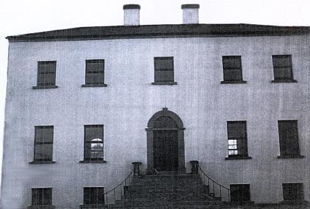
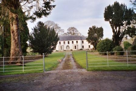
Bettyfield
Houses within 10km of this house
Displaying 38 houses.
Houses within 10km of Bettyfield
Displaying 38 houses.
| House name | Description | |
|---|---|---|
| Camlin | The representatives of John Irwin, a minor, were leasing a house at Camlin, valued at £14, to James Badger, at the time of Griffith's Valuation. In 1837 Lewis also recorded Camlin as the seat of the Irwin family. At the time of the 1st Ordnance Survey, Camlin was being leased by John Irwin from the estate of Guy Lloyd and was described as "a good house of three stories". In 1814 it was the seat of John Irwin. At the time of the 1749 Census of Elphin a John Irwin lived at Camlin. |
|
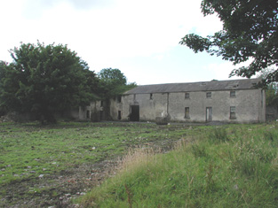
| Croghan | At the time of Griffith's Valuation, Guy Lloyd was the occupier of the house at Croghan, valued at £40. In 1749 the Census of Elphin shows that J. Lloyd, spinster, lived there. Wilson also notes it as a seat of the Lloyd family in 1786. Croghan House is no longer extant but an extensive range of outbuildings remains. |
|
| Cloverhill | At the time of Griffith's Valuation, Thomas Cox was leasing a house from the Lloyd estate at Bunreagh, barony of Boyle, valued at £10 . This property is labelled Cloverhill on the 25-inch map of the 1890s. A house and substantial farn are still extant at the site. | |
| Hermitage | Lewis records the Lloyd family occupying a second house called Hermitage also located in the townland of Croghan. Buildings still exist at the site. | |
| Carrowreagh | Richard O'Farrell Caddell was leasing a "herd's" house valued at £8, together with over 350 acres, at Carrowreagh, barony of Boyle, to Thomas Boylan, at the time of Griffith's Valuation. A house and farm are still extant at the site. Patrick Fox was leasing a mill property from the Caddell estate in the same townland. Some stone buildings remain at the site though the mill was described as "in ruins" on the 25-inch Ordnance Survey map of the 1890s. | |
| Finnor House | At the time of Griffith's Valuation, Richard O'Farrell Caddell was leasing a house valued at £8, at Finnor, barony of Boyle, to Michael Barrett. It s labelled "Finnor House" on the 25-inch Ordnance Survey map of the 1890s and a house still exists at the site. | |
| Bella | At the time of Griffith's Valuation Arthur O'Connor was the lessor of a caretaker's house, valued at £2 10s, as well as 136 acres. Lewis recorded Bella as the residence of E. French in 1837. A ruin is still extant at the site. An entrance gateway named Flynn's Cottage is visible here now! | |
| Dooneen | The representatives of Daniel Ferrall were leasing a property valued at £5 together with 200 acres to John Sharkey at the time of Griffith's Valuation. A farm is still extant at this location. | |
| Scor More | At the time of Griffith's Valuation, Scor More was leased to Patrick Beirne by the Lloyd estate and was valued at £3. 100 acres was also leased. This house is not shown on the 1st edition of the OS map. | |
| Portobello | At the time of Griffith's Valuation, John Stafford was leasing a property at Portobello valued at £13 from Lord Lorton's estate. In 1814 it had been the residence of Thomas Stafford who Lewis also recorded as resident there in 1837. | |
| Ryefield | At the time of Griffith's Valuation Andrew Cummins was leasing a house at Ryefield valued at £17 to John Dowd. It was occupied by John Cummins, agent to Nicholas Cummins at the time of the first Ordnance Survey. | |
| Peak | Richard Irwin owned a herd's house and over 370 acres at Peak, barony of Castlereagh at the time of Griffith's Valuation. A modern house has been constructed at the site. | |
| Cloonyquin | Home of the French family, including the song writer Percy French, sold by the family in the 1950s. In 1786 Wilson refers to it as a seat of Arthur French in 1786. Valued at £24 in the mid 19th century. The house was demolished in the 1960s. See www.percyfrench.ie. |
|
| Smith Hill | Smithhill was in the demesne of The Palace at Elphin. It was the residence of the Reverend Oliver Jones, grandfather of Oliver Goldsmith, in the early 18th century. It was the home of Robert Jones Lloyd in the late 18th and early 19th century and of the Reverend John Lloyd in 1837. The house was unoccupied at the time of Griffith's Valuation when it was valued at £8 and held by Robert Lynch. The Ordnance Survey Field Name Books record that Goldsmith's father was born at Ardnagowna [or possibly Oliver himself, see http://en.wikipedia.org/wiki/Smith_Hill_(house)]. |
|
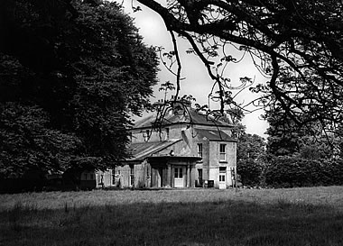
| Mantua | Built in the mid 18th century and owned by the Grace family in the 18th and 19th centuries. Occupied by R. Underwood in 1778. In 1786 Wilson notes that it was the seat of the late Richard Underwood and of Captain Grace. The 1st edition Ordnance Survey map indicates that it had elaborate gardens with a fishpond and terrace. It was owned by Edward F. Bowen in 1906. Mantua is now a ruin. | |
| Rush Hill | Home of the Devenish family in the 18th and 19th centuries, held from Sir Gilbert King. Funding received from the Heritage Council in 2005 for the restoration of this house. http://www.iol.ie/~oldbuilders/oldbuilders/rushhill/rushhill_01.htm. A detailed history and account of ongoing improvements to Rush Hill can be found at the blog www.irishaesthete.com tagged as Rush Hill. |
|
| Lissadorn | Lissadorn was a Crofton home from the mid 17th century. It became a Lloyd home in the 18th century following the marriage of Catherine Crofton and John Yeadon Lloyd in 1786. By 1814 Joseph Healy was living at Lisadurn. Burke's ''Landed Gentry of Ireland'' (1904) records the second son of Walter Balfe of Heathfield as John Balfe of Lissadorn. J. Balfe was residing at Lissadorn in 1837. At the time of Griffith's Valuation, Bernard Balfe held Lissadorn, valued at £20, from Viscount Lorton. It is no longer extant. On the first Ordnance Survey map (1838) the demesne included a smaller house named Ryefield. |
|
| Cargins Park | The home of the Kelly family from the mid 18th century. Wilson refers to "Cargans, the seat of the late Daniel Kelly" in 1786. It was occupied by John D'Arcy when the estate was sold in 1852. A Victorian three bay house was the home of Daniel Kelly. Sold to Captain Drought in the mid 19th century, held by him in fee and valued at £15. The present house is not the same as Kelly's Victorian one. Renovated in the early 21st century. | |
| Cloonfree | The residence of William Mahon. Apparently the residence of George Knox in the 1840s. http://www.ballykilcline.com/story_f.html | |
| Cloonahee | Residence of Gilbert Conry in 1814 and of John Conroy esq in 1822. According to a note with the sale rental of 1853 the house was accidently burnt and a good farm house built as a replacement. The home of John Heague in the mid 19th century. Occupied by Richard Hague and valued at £40 in 1906. |
|
| Clogher Beg | Mary Gormley writes that this house was built by the Knoxes who acquired some of the Plunkett of Castle Plunkett estate. Occupied by Thomas Stafford at the time of Griffith's Valuation, held from James Murphy. | |
| Foxborough | In 1786 Wilson refers to Foxborough as the seat of Arthur French. Occupied by Patrick Taaffe at the time of Griffith's Valuation, who was leasing from Christopher French. The house was then valued at £20. It is now a ruin though the stable yard survives. | |
| Raheen | Occupied by Major Fawcett in 1837 and by John Irwin in the mid 1850s who held the property from Francis Murphy. In 1840 John Irwin had married Margaret Harken of Raheen House, Elphin. |
|
| Ardkeenagh House | Michael Plunkett was farming at Ardkeenagh in 1749. In 1814 it was the home of Nicholas Peyton and of Mrs Hawkes in 1837. At the time of Griffith's Valuation the house was vacant but the surrounding lands were held by Patrick Moran from James Somerville. Buildings are still extant at the site. | |
| Bloomfield | In the possession of John Farrell in 1814 and of H. O'Farrell medical doctor in 1837. In the mid 19th century held by the Reverend Peter Toler in fee and valued at £10. Toler appears to have purchased Bloomfield from the sale of the Cargins Park estate by the trustees of Daniel Kelly. | |
| Cloonmurray | Leased by Marcella Dillon to the Reverend Michael Lennon at the time of Griffith's Valuation and valued at £9. Some ruins remain at the site. | |
| Mount Browne | At the time of Griffith's Valuation occupied by George Browne who held the property from James G.Plunkett, valued at £25. The sale rental of the Gunning Plunkett estate in June 1857 states that Mount Browne was held by a fee farm grant from Jane Plunkett, mother and guardian of the owner, to George Browne, dated 30 Oct 1852. Occupied by the representatives of Arthur Browne in 1894 and 1906. | |
| Creta | Occupied by George Harken in 1814 and Daniel Hughes in the mid 1850s and valued at £8. Creta Cottage was occupied by Captain Dillon in 1837. A house is still extant at the site. | |
| Cherryfield | Home of the Mills family in 1778. Noted by Wilson as "the fine seat of Oliver Mills" in 1786. Lewis refers to it as a seat of the same family in 1837. It was occupied by Michael Butler in the 1850s and held from John Carroll, valued at £10. It came into the ownership of the McGreavy family in the latter part of the nineteenth century and remained in their possession until the 1960s. It is now derelict. | |
| Beech Abbey | Originally a Begg residence, Beech Abbey in the mid 1850s was occupied by William Acheson, who was the main tenant of the Babington lands in the parish of Aughrim. The house was only valued at £2.10 shillings. It appears to have fallen into ruin by the 1890s. | |
| Lisroyne Lodge | A house on the outskirts of Strokestown, part of the Strokestown House demesne, valued at £10 at the time of Griffith's Valuation and occupied by Michael Flynn. Some buildings are still extant at the site. | |
| The Palace | Built as the residence of the Protestant Bishop of Elphin in 1685 from money bequeathed by Bishop Hudson. Altered in the mid 18th century and remained as the Bishop's residence until 1845. At the time of Griffith's Valuation the home of Arthur O'Conor, younger brother of Denis O'Conor of Mount Druid. Valued then at £55 and held from the Ecclesiastical Commissioners. Accidentally burnt in 1911, the main block is now demolished. | |
| Toomona | The home of Michael Connor, a gentleman in 1749, just outside Tulsk. The residence of Michael's grandson Peter O'Connor in 1814 and 1837. At the time of Griffith's Valuation Toomona was valued at £10 and was occupied by Maria French who held it from Lord Crofton. Later occupants included Colonel Lynham, Matt Flanagan, the Murphy and Fallon families. Accidently burnt in the 1970s. | |
| Kinard | Possibly a Plunkett house at the end of the 18th century. At the time of Griffith's Valuation John Clarke occupied the house which he held from James Somerville, valued at £5. It is labelled Kinard House on both the 1st and 25-inch edition Ordnance Survey maps. A house is still extant at the site. | |
| Lisnaneane | Gormley states that the widow of Dominick O'Conor Don lived at Lisnanean after Dominick's death in 1795. Later it was the home of Malachy Madden in 1814 and of Catherine O'Conor Don's nephew Robert Nolan and his family in the 1830s. No demesne is marked on the first Ordnance Survey map. At the time of Griffith's Valuation the house was valued at £5 and was held by Robert Nolan in fee. A house still exists at the site. | |
| Rossmore | Rossmore East was part of the estate of James Murphy at the time of Griffith's Valuation. The house was built circa 1860s (Buildings of Ireland). However the Ordnance Survey Field Name Books record a house and large gardens in the 1830s. |
|
| Corbally House (Roscommon) | Patt Dunn, an agent, was living at Corbally in 1749. The home of members of the Plunkett family in the early 19th century. Occupied by William Phibbs at the time of Griffith's Valuation, held from John Egan and valued at £8. A house still exists at the site. | |
| Ballyoughter | Occupied by John Goldsmith at the time of Griffith's Valuation. He held the house valued at £8 and 60 acres from Marcus McCausland. Another John Goldsmith was residing in Ballyoughter a hundred years earlier at the time of the Elphin Census. Wilson also refers to the house as the seat of Mr. Goldsmith in 1786. A later house, also named Ballyoughter House, is shown on the 25-inch Ordnance Survey map of the 1890s and there is still a house at this site, |