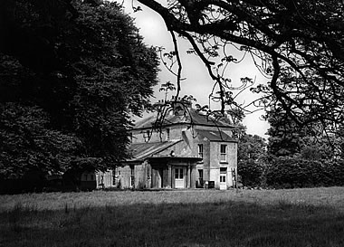
Foxborough
Houses within 5km of this house
Displaying 12 houses.
Houses within 5km of Foxborough
Displaying 12 houses.
| House name | Description | |
|---|---|---|
| Cloonyquin | Home of the French family, including the song writer Percy French, sold by the family in the 1950s. In 1786 Wilson refers to it as a seat of Arthur French in 1786. Valued at £24 in the mid 19th century. The house was demolished in the 1960s. See www.percyfrench.ie. |
|
| Cargins Park | The home of the Kelly family from the mid 18th century. Wilson refers to "Cargans, the seat of the late Daniel Kelly" in 1786. It was occupied by John D'Arcy when the estate was sold in 1852. A Victorian three bay house was the home of Daniel Kelly. Sold to Captain Drought in the mid 19th century, held by him in fee and valued at £15. The present house is not the same as Kelly's Victorian one. Renovated in the early 21st century. | |
| Ardkeenagh House | Michael Plunkett was farming at Ardkeenagh in 1749. In 1814 it was the home of Nicholas Peyton and of Mrs Hawkes in 1837. At the time of Griffith's Valuation the house was vacant but the surrounding lands were held by Patrick Moran from James Somerville. Buildings are still extant at the site. | |
| Bloomfield | In the possession of John Farrell in 1814 and of H. O'Farrell medical doctor in 1837. In the mid 19th century held by the Reverend Peter Toler in fee and valued at £10. Toler appears to have purchased Bloomfield from the sale of the Cargins Park estate by the trustees of Daniel Kelly. | |
| Cloonmurray | Leased by Marcella Dillon to the Reverend Michael Lennon at the time of Griffith's Valuation and valued at £9. Some ruins remain at the site. | |
| Mount Browne | At the time of Griffith's Valuation occupied by George Browne who held the property from James G.Plunkett, valued at £25. The sale rental of the Gunning Plunkett estate in June 1857 states that Mount Browne was held by a fee farm grant from Jane Plunkett, mother and guardian of the owner, to George Browne, dated 30 Oct 1852. Occupied by the representatives of Arthur Browne in 1894 and 1906. | |
| Bettyfield | Recorded as the seat of Sir John Conroy or O'Mulconry in the Ordnance Survey Field Name Books. Arthur O'Connor was the main tenant in the townland of Shankill at the time of Griffith's Valuation. | |
| Cherryfield | Home of the Mills family in 1778. Noted by Wilson as "the fine seat of Oliver Mills" in 1786. Lewis refers to it as a seat of the same family in 1837. It was occupied by Michael Butler in the 1850s and held from John Carroll, valued at £10. It came into the ownership of the McGreavy family in the latter part of the nineteenth century and remained in their possession until the 1960s. It is now derelict. | |
| Lisnaneane | Gormley states that the widow of Dominick O'Conor Don lived at Lisnanean after Dominick's death in 1795. Later it was the home of Malachy Madden in 1814 and of Catherine O'Conor Don's nephew Robert Nolan and his family in the 1830s. No demesne is marked on the first Ordnance Survey map. At the time of Griffith's Valuation the house was valued at £5 and was held by Robert Nolan in fee. A house still exists at the site. | |
| Rossmore | Rossmore East was part of the estate of James Murphy at the time of Griffith's Valuation. The house was built circa 1860s (Buildings of Ireland). However the Ordnance Survey Field Name Books record a house and large gardens in the 1830s. |
|
| Corbally House (Roscommon) | Patt Dunn, an agent, was living at Corbally in 1749. The home of members of the Plunkett family in the early 19th century. Occupied by William Phibbs at the time of Griffith's Valuation, held from John Egan and valued at £8. A house still exists at the site. | |
| Ballyoughter | Occupied by John Goldsmith at the time of Griffith's Valuation. He held the house valued at £8 and 60 acres from Marcus McCausland. Another John Goldsmith was residing in Ballyoughter a hundred years earlier at the time of the Elphin Census. Wilson also refers to the house as the seat of Mr. Goldsmith in 1786. A later house, also named Ballyoughter House, is shown on the 25-inch Ordnance Survey map of the 1890s and there is still a house at this site, |