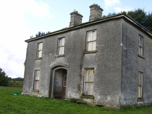
Cloonatleva
Houses within 10km of this house
Displaying 51 houses.
Houses within 10km of Cloonatleva
Displaying 51 houses.
| House name | Description | |
|---|---|---|
| Woodlawn | Wilson mentions Woodlawn as "a very superb ediface", the seat of Frederick Trench, in 1786. In 1837 Lewis recorded Woodlawn as the seat of J. Trench and mentions the extraordinary mausoleum nearby. At the time of Griffith's Valuation, the house and buildings at Woodlawn were valued at £125, one of the highest buildings valuations in county Galway at that time. In 1894 Slater refers to Woodlawn House as the seat of John Samuel Barrett. By 1906 it had a value of £150 and was in the possession of Lord Ashtown. Woodlawn House is still extant but unoccupied. |
|
| Vermount | Also known as Munine or Moneen, the house was described as 'in ruins' on the Ordnance Survey 6 inch map (1932), following its burning in 1923. Extensive outbuildings are still in use and part of the yard is now a residence. McHale writes that this was, in fact, the original house. The National Inventory of Architectural Heritage suggests that the family occupied this building while Vermont House was being constructed. In 1786, Wilson refers to a house called "Munnine" as a seat of Mr. French. |
|
| Mounthazel | Occupied by Catherine Mahon at the time of Griffith's Valuation when the house was valued at £45. Mounthazel may be the property referred to by Wilson in 1786 as Bunrea, the seat of Mr. Davies. Demolished in 1945 though traces of the walled garden remain. |

|
| Mountbernard | Home of Bernard Browne in the 1830s. Occupied by James C. [Leslie] Foster at the time of Griffith's Valuation, leasing from Andrew Browne, when the house was valued at £35 Foster was married to Henrietta, daughter of Sir Ross Mahon of Castlegar. The house is now in ruins. |
|
| Waterloo House | In 1786, Wilson refers to a house in this area as Fair-Hill, the seat of Mr. French. Waterloo was the home of the Concannons from the 1820s to the early 20th century. It was held in fee by Edmund Concannon at the time of Griffith's Valuation, when it was valued at over £20. It is still extant and occupied. |
|
| Ticooly/Tycooly | Occupied by the O'Kellys in the 18th and early 19th centuries. By the time of Griffith's Valuation it was part of the Clonbrock estate and was valued at £16. A building on a slightly different site, is noted as Tycooly House on the 25-inch Ordnance map of the 1890s. There is still an extant property at this site. |
|
| Killagh | Lands at Killaghmore and Clonecallin amounting to 635 acres were granted to Edmond Donnellan in 1684. Wilson refers to it as the seat of Mr. Donnellan in 1786. Stephen Donnellan was occupying the property at Killagh, valued at £33, at the time of Griffith's Valuation. In 1906 it was in the possession of Stephen J.R. Donnellan. It is no longer extant. |

|
| Esker Lodge | James Martin was leasing a property valued at £15 from Andrew Browne's estate at Esker, barony of Tiaquin, at the time of Griffith's Valuation. It is labelled Esker Lodge on both the 1st and 25-inch edition Ordnance Survey maps. A small amount of ruins remain at the site. | |
| Cruise Lawn | Held by William Cruise from James Galbraith at the time of Griffith's Valuation when the house was valued at £5. It is named Cruice Lawn on the 25-inch Ordnance Survey map of the 1890s. Cruice Lawn is now a ruin. | |
| Greenville | Occupied by William Dillon in 1814, by P. Cruise in the 1830s and by John F. Browne at the time of Griffith's Valuation when it was valued over £5 and was part of a farm of over 250 acres. Peter Tyrell was leasing a mill at Greenville from the Bellew estate at the same time. Buildings, including the substantial stables, still exist at the site. |

|
| Caltra Lodge | The home of P.J.Joyce in the late 1830s and of Mary Joyce in the 1850s. The Joyces held this house from the Bellews of Mount Bellew. On the 25-inch map of the 1890s it is labelled as Caltra Park. The ruin of the original house was visible until the end of the twentieth century, | |
| Corgary or Corgerry | The house known as Corgary was part of the Joyce estate. At the time of Griffith's Valuation, it was occupied by Eleanor Morgan, leasing from Walter Joyce, and valued at £30. It was shown on the 25-inch Ordnance Survey map of the 1890s but labelled "in ruins" on the 6-inch map of 1932. | |
| Beech Hill | Beech Hill was built in the mid to late 18th century. In 1786 Wilson mentions it as the seat of Mr. Mahon. In 1814 Beech Hill was the residence of Bernard Mahon. It was offered for sale by the Mahons in 1851 and it was owned at the time of Griffith's Valuation by Edward C. Villiers and was valued at £26. In 1906 Beech Hill House was still valued at £26. It is now in ruins. |
|
| Creeraun | At the time of Griffith's Valuation the townland was held by Margaret O'Kelly and the house and some land was occupied by Anthony O'Kelly. In the sale particulars of Creeraun in 1889 the house is marked on the map as 'in ruins'. |

|
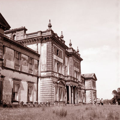
| Clonbrock | Designed by William Leeson and built in the 1780s. In 1837 Lewis recorded it as the seat of Lord Clonbrock. In 1786 Wilson refers to Clonbrock as the seat of R. Dillon. At the time of Griffith's Valuation the house at Clonbrock was valued at £100. In 1906 it was valued at £135. The house was badly damaged by fire in the 1980s and only one wing is now inhabited. |
|
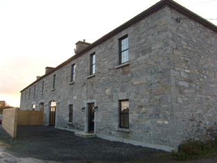
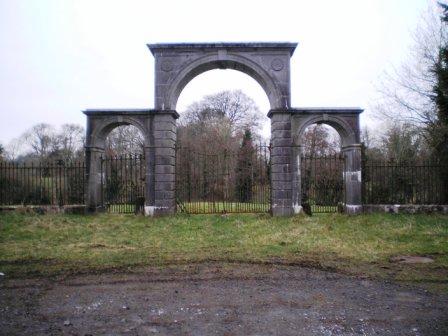
| Ballybaun | At the time of Griffith's Valuation, Lord Clonbrock owned a mill, gate house and other buildings valued at £35 in the townland of Ballybaun, parish of Ahascragh. The gate house is still extant and occupied. Local sources suggest it was at one time used as a school for children in the area. |
|
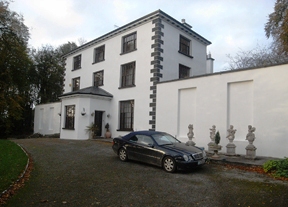
| Ahascragh Glebe/Rectory | At the time of Griffith's Valuation, Rev. Sir William Mahon was leasing a house valued at £20 in the townland of Ahascragh West, barony of Kilconnell, to Reverend Peter Browne. He was also leasing property in this townland to Thomas Hunt. Reverend Mahon was rector of Rawmarsh, Yorkshire. This property is still extant and occupied as a private house. |
|
| Carrownea | At the time of Griffith's Valuation, William Evans was leasing a property valued at £10 at Carrownea, parish of Ballymacward, from the Clancarty estate. Earlier in 1837, Lewis had recorded Carrownea as the seat of J. Fitzsimons. Flynn writes that, in 1850, the lease of Carrownea House and lands passed to William Evans, brother of John Cannon Evans of Cross House. There is still an extant house at Carrownea. | |
| Hampstead | Built in the mid-18th century. In 1814 Hampstead House was the residence of John Bodkin. In 1837 Lewis recorded it as the seat of F.Davis. In 1853 it was occupied by Thomas Pilkington Davies who was leasing it from George Davies. At the time of Griffith's Valuation it was leased by the Morgan family to Martin Blake. In 1906 it is recorded as being part of the estate of James Johnston. It is now a ruin. |
|
| Greenhills | Samuel Barrett was leasing a house valued at £24 from John Blakeney in 1856. In 1837 Lewis had recorded Greenhills as the seat of S. Barrett. In 1885 Walford noted that it was the residence of Mrs. Barrett, widow of John Samuel Barrett. In 1906 Greenhills was part of the estate of Lord Ashtown (Trench). The house is still extant but derelict. |

|
| Pallas | At the time of Griffith's Valuation John J. Bodkin was leasing a property at Pallas, parish of Fohanagh, to Thomas O'Connor. The house was valued at £3 but was accompanied by over 600 acres. A new house appears to have been constructed after the publication of the 1st edition Ordnance Survey map. It is labelled Pallas on the 25-inch edition of the 1890s. It is now derelict. |
|
| Doon House | At the time of Griffith's Valuation Charles Filgate was leasing a house valued at £5 and 400 acres from the Clonbrock estate. In the 1830s, he is noted in the Ordnance Survey name books as the agent for several county Galway estates, including the Mahons of Castlegar and the Blakeneys of Abbert. Doon House wsa constructed within a ring fort and the remains of the building still exist. | |
| Lowville | Lowville was originally the seat of Nathanial Lowe who held this estate in the mid-18th century and Wilson refers to it as his seat in 1786. In 1814 it was the residence of the Hon. Mrs. Low. In 1837 Lewis recorded Lowville as the seat of W. McDonagh. It was still occupied by Walter McDonagh in the 1850s and was valued at £45. By 1906 it was in the possession of Bernard Connaughton and was valued at £33. It was later the home of the Byrne family but was sold in the early 1970s and ceased to be residential. It is now a ruin. |
|
| Ballinderry (Comyn) | Lewis records Ballinderry as the seat of J. Comyn in 1837. At the time of Griffith's Valuation it was being leased by Andrew Comyn from the Ecclesiastical Commissioners and was valued at £16. Recorded as the residence of Col.John Comyn in 1894. In 1906 it was the property of Andrew N. Comyn. Ballinderry House is still extant and is now operated as a luxury country house hotel. See www.ballinderrypark.com. |

|
| Barnavihall House | At the time of Griffith's Valuation John Connolly was leasing this property, valued at £8, together with over 250 acres, from R.W. Greene. There is still an extant house at the site. |
|
| Carrowmanagh Cottage | Carrowmanagh Cottage was the residence of Rev. Edward Hartigan in 1814. In 1837 Lewis records it as the seat of Thomas Bermingham. It was included in the sale of the Ashtown estate in the Encumbered Estates court in 1851. At the time of Griffith's Valuation it was leased by Rev. Frederick Trench to Crawford Allen. Some ruins remain at the site. | |
| Hillswood | In 1837 Lewis recorded Hillswood as the seat of Hyacinth Donnellan. At the time of Griffith's Valuation in 1856 Edmund Donnellan was leasing the house at Hillswood, together with almost 300 acres, to Obadiah Holland. It is no longer extant. | |
| Woodlawn Hotel | At the time of Griffith's Valuation, Lord Ashtown was leasing a hotel property valued at £13 in the townland of Carrowmore, barony of Kilconnell, to William Menziey. | |
| Woodberry House (Kilconnell) | William Hemsworth was occupying this property, valued at £10, at the time of Griffith's Valuation when he was leasing it from Seymour Harrison. In 1894 Slater states that it was in the possession of Patrick J. Davy and he is also listed as the owner in 1906. . Earlier, in 1814, Leet noted it as the seat of Peter Daly. It is still extant and occupied. |
|
| Streamsford | The house at Streamsford, parish of Killimordaly, was leased from James O'Hara to Patrick Cogovan.and valued at £10 at the time of Griffith's Valuation. It is still extant and occupied. |
|
| Northbrook Cottage | Lewis records Northbrook as the seat of J. North in 1837. The Ordnance Survey Name books note Major Warburton as the proprietor of the townland. The First Edition Ordnance map shows Northbrook Cottage. At the time of Griffith's Valuation, a house in progress in the townland was being leased by Joseph Denham from James McBride and was valued at £3 10s. This house is labelled Northbrook House on the 25-inch map of the 1890s. It is now a ruin. |
|
| South Park | At the time of Griffith's Valuation, Lawrence Kerrans was leasing a property valued at £11 from the Clonbrock estate at Kilglass, parish of Ahascragh. It is not named on the first edition Ordnance Survey Map but is labelled South Park on the 25-inch edition produced in the 1890s. The house is still extant and occupied. |
|
| Clooncannon/Cloncannon/Runnamead | Far Kelly was resident at Cloncannon in 1749. It is described in the Ordnance Survey Name Books as the residence of William Kelly. This property was offered for sale in the Encumbered Estates in July 1850. At that time it was occupied by Mathew C. Browne. John and Edward Lennon were occupying this property, valued at £9, at the time of Griffith's Valuation. It was part of a holding of almost 400 acres. Joseph Trumperant Potts laid the foundation stone for his house known as Runnymeade in 1866 (''Saunders Newsletter'', 23 June 1866). It is labelled as Runnamead House on the 25-inch Ordnance Survey map of the 1890s. In 1906 a house valued at £10 at Clooncannon Kelly was part of the Clonbrock estate together with almost 400 acres of untenanted land.. It is no longer extant. | |
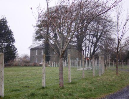
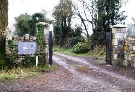
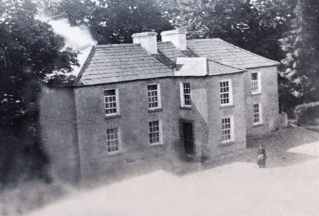
| Weston | John D. Mahon was leasing this property, valued at £35, from Sir William Mahon, at the time of Griffith's Valuation. It is described as unoccupied at the time of the first Ordnance Survey. The National Inventory of Architectural Heritage indicates that the original Weston house is now demolished. A smaller house, known as Weston Lodge, was also located in the demesne (M779403). It is no longer extant. |
|
| Ballyglass House | James Mahon, a brother of Ross Mahon of Castlegar, was residing at Balliglass in 1749. The Ordnance Survey Name Books record it as the residence of George Clarke in the 1830s. A herd's house valued at £5 and over 250 acres of the Mahon estate were located at Ballyglass in the parish of Ahascragh at the time of Griffith's Valuation. A house still exists at the site. | |
| Sonnagh | Walter McDonagh was leasing a property at Sonnagh, parish of Fohanagh, barony of Clonmacnowen, from the Clancarty estate at the time of Griffith's Valuation. He was also the occupier of a mill at Pollboy, valued at £95, in this parish. His estate was centred on Lowville in the barony of Kilconnell. A house still exists at the Sonnagh site. | |
| Knockglass | Charles Masters was leasing buildings valued at £14 which included a mill at Knockglass, parish of Kilcloony, barony of Clonmacnowen, from the Ashe estate at the time of Griffith's Valuation. Builidings are still extant at the site. | |
| Fairfield (Kilgerrill) | Wilson, writing in 1786, notes Fairfield as the seat of Mr. O'Brien. In 1837, Lewis records Fairfield as the seat of John O'Brien. At the time of Griffith's Valuation Fairfield was leased by James Thorngate to Daniel Cruise. Taylor and Skinner record Fairfield as a seat of the O'Brien family in 1783. The original house is not extant. |
|
| Heathview House | At the time of Griffith's Valuation, Christopher Usher was leasing buildings including a mill, valued at £25, to William Usher, in the townland of Kilgerrill, barony of Clonmacnowen. Earlier, in 1837, "The Lodge" in the parish of Kilgerrill was recorded by Lewis as the seat of William Usher. Described by the Ordnance Survey Name Books as "in good repair", it was then the residence of J. Usher. A house still exists at the site. | |
| Mountventure | Occupied by John Evans in 1814. James Raftery was leasing it from the Clancarty estate at the time of Griffith's Valuation when it was valued at almost £10. The house is no longer extant though some walls remain. | |
| Castlegar | The principal residence of the Mahon family, designed by Sir Richard Morrison circa 1801, replacing an earlier house. Wilson, writing in 1786, refers to this earlier house as the seat of Mr. Mahon. In the 1830s the Ordnance Survey Name Books describe it as in good repair but Sir Ross Mahon was not resident there at the time. Sir William Mahon was still in possession of the property in 1906 when it was valued at £67. In 1979 the house was sold by the Mahons to John Horan, who advertised the house for sale again in 1988. The house is still extant. |
|
| Sprucehill House (Kilconnell) | Sprucehill House is noted as the residence of Samuel Harrison in 1814. By the time of Griffith's Valuation the occupied property in this townland is a herd's house, part of the Longworth estate and valued at £2. Sprucehill House is described as "in ruins" on the 25-inch Ordnance Survey map of the 1890s. | |
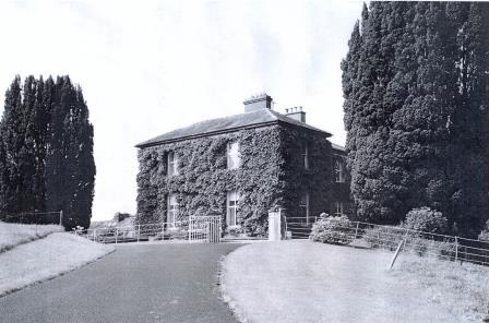
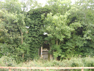
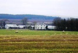
| Cloonatleva Mill | James Tyrrell was leasing a house and mill, valued at £6, together with land, at Cloonatleva, barony of Kilconnell, from the Hodson estate at the time of Griffith's Valuation. The building is described as "disused" on the 25-inch Ordnance Survey map of the 1890s. | |
| Killareeny | The Return of Untenanted Lands [1906] records a mansion house valued at £25 at Killareeny, parish of Aughrim, the property of George K. Mahon. This property was built in the late nineteenth century and is labelled Killareeny House on the 25-inch Ordnance Map of the 1890s. Rev. John Crawford was the lessor of the townland at the time of Griffith's Valuation. The original house is not extant now. | |
| Fohenagh | Sir Henry Grattan Bellew dates this house from the 1830s. In 1906 Norah Johnston was the owner of buildings valued at £10 at Fohenagh as well as over 500 acres of untenanted land. Various members of the Johnston family had held lands in the area at the time of Griffith's Valuation mostly leased from the Hodson estate. Buildings still remain at this site. | |
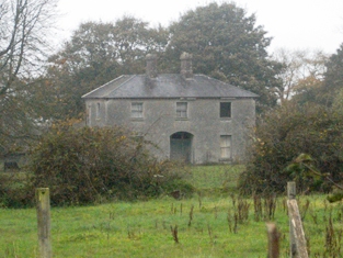
| Killaghbeg | Denis Deely was leasing a property valued at £4 from the estate of Hon. John Plunkett at the time of Griffith's Valuation. The Ordnance Survey Name books indicate that this townland was part of Lord Clonbrock's estate in the 1830s. The house is labelled Killaghbeg House on the 25-inch Ordnance Survey map of the 1890s. In 2010 it was extant but unoccupied. |
|
| Alloonbaun/Church View | At the time of Griffith's Valuation Rev. Joseph Seymour was leasing this house from the Clancarty estate when it was valued at almost £8. It is still extant and occupied. |
|
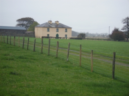
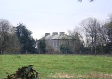
| Milverton | Thomas Hunt was leasing a property valued at £20 from the Mahon estate at the time of Griffith's Valuation. Extensive corn mills are shown at this site at the time of the First Ordnance Survey but by the 1890s it is occupied by a house labelled Milverton which is still extant. |

|
| Ashfield (Tiaquin) | IN 1786, Wilson refers to Ashfield as the seat of Mr. Blakeney. On the 1st edition Ordnance Survey map a tree-lined avenue and buildings are shown but not named. None of the buildings are visible today though a portion of the avenue remains. | |
| Newcastle (Kilconnell) | In 1786 Wilson refers to Newcastle as the seat of Mr. Davis. This townland was partly owned by the Longworths of Oatfield by the time of Griffith's Valuation. | |
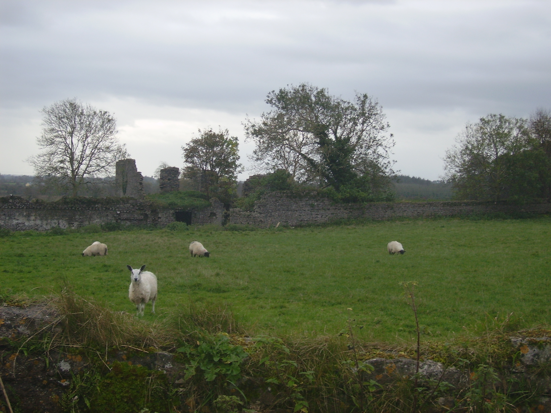
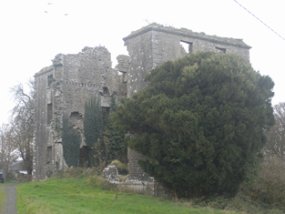
| Killure | Writing in 1786, Wilson refers to Killure as the seat of Mr. Dillon. He appears to be referring to either Killure Castle or a property associated with it. The castle is described as "in ruins" on the 1st edition Ordnance Survey map of 1842 and the ruin of the tower house is still visible. |