Haines/Haynes
In his will made in 1825 Charles Haines of Mallow, county Cork, mentions his sons Thomas, Humphrey, Charles and Homan and a number of daughters. In 1837 Lewis refers to the "extensive boulting mills of Messrs Haines and Smith" in the parish of Ballyclogh. At the time of Griffith's Valuation Charles Haynes held land in the parish of Kilshannig, barony of Duhallow, county Cork. In July 1854 Clyda House and part of the lands of Gurtmore Upper, barony of Duhallow, were advertised for sale. Clyda House was held under a lease dated 19 July 1814 Charles Haines to his son Thomas. By the 1870s Charles Haines and Charles C. Haines both of Mallow, owned 277 and 215 acres respectively in county Cork. http://www.igp-web.com/IGPArchives/ire/cork/wills/haines9gwl.txt
Associated Families
Houses
| Name | Townland | Civil Parish | PLU | DED | Barony | County | Map Ref | |
|---|---|---|---|---|---|---|---|---|
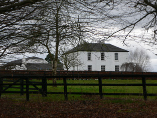
| Clydaville | Clydaville | Kilshannig | Mallow | Kilshannig 248 | Duhallow | Cork |
OSI Ref: W537 972
OS Sheet: 33 Discovery map: 80 |
|
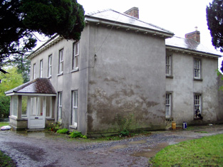
| Woodfort | Kilvealaton East | Kilshannig | Mallow | Kilshannig 248 | Duhallow | Cork |
OSI Ref: W532 972
OS Sheet: 32 Discovery map: 80 |

|
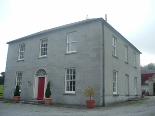
| Clyda | Clyda | Kilshannig | Mallow | Kilshannig 248 | Duhallow | Cork |
OSI Ref: W536 974
OS Sheet: 33 Discovery map: 80 |
|
| Ballyclogh Castle | Ballyclogh | Ballyclogh | Mallow | Kilmaclenine 235 | Orrery and Kilmore | Cork |
OSI Ref: R493 020
OS Sheet: 24 Discovery map: 73 |
|
| Blossomfort | Blossomfort | Ballyclogh | Mallow | Kilmaclenine 235 | Orrery and Kilmore | Cork |
OSI Ref: R491 011
OS Sheet: 24 Discovery map: 73 |
|
| Sunnyside | Curraghanearla | Mallow | Mallow | Mallow Rural 250 | Fermoy | Cork |
OSI Ref: R556 007
OS Sheet: 33 Discovery map: 73 |
|
Map of Estate Houses
Click on the markers to view more details about each house.
Archival sources
- Encumbered Estates' Court Rentals (O'Brien), Haines, 29 July 1854, Vol 30 (19), MRGS 39/013, (microfilm copy in NUIG); National Archives of Ireland
- Papers relating to the estate of the Haines family at Gortmore, Duhallow Barony, Co. Cork, 18th - 19th c. M.5565 (1-7) ; National Archives of Ireland
- Irish Tourist Association Survey files, Parish of Glantane; Cork County Library
Contemporary printed sources
- ''GRIFFITH'S VALUATION OF IRELAND'[Primary Valuation of Tenements]', 1850-1858. : Barony of Duhallow Part II, 13 (Clyda & Clydaville), 27 (Kilvealaton East)
- PARLIAMENTARY PAPERS. ''Return of owners of land of one acre and upwards, in the several counties .... in Ireland''. HC 1876, LXXX: 125
- LEET, Ambrose. ''A directory to the market towns, villages, gentlemen's seats, and other noted places in Ireland''. Dublin: Printed by B. Smith, 1814 : 121 (Clyda & Clydaville), 391 (Woodford)
- LEWIS, Samuel. ''A Topographical Dictionary of Ireland''. London: S. Lewis & Co., 1837: I, 129 (parish of Ballyclogh), II, 208 (parish of Kilshannig)
- SMITH, Charles, M.D. ''The ancient and present state of the county and city of Cork. Containing a natural, civil, ecclesiastical, historical and topographical description thereof ''. First published 1750. This edition published Cork: John Connor, 1815: I, 301
- ''GRIFFITH'S VALUATION OF IRELAND'[Primary Valuation of Tenements]', 1850-1858. : Barony of Orrery & Kilmore, 5 (Ballyclogh) & 8 (Blossomfort)
- TAYLOR, George & SKINNER, Andrew. ''Maps of the Roads of Ireland, surveyed in 1777 and corrected down to 1783''. Facsimile of 2nd edition. Shannon: Irish University Press, 1969: 182 (Wood fort - Ousley)
Modern printed sources
- ''Jnl. of the Cork Historical and Archaeological Society''.: Historical and Topographical Notes, etc on Buttevant, Doneraile, Mallow and Places in their vicinity. Collected by James Grove White (c 1906). XXVI, 2nd Series (1920), 237 (Sunnyside)