Leader (Keale)
A junior branch of the Leader family of county Cork, sharing a common ancestry with the Leaders of Mount Leader. Early generations married members of the Radley family. John Leader was living at Keale, Millstreet, by the beginning of the 18th century and his descendants continued to live at Keale until the property was sold in the early 20th century. The estate was situated in the parishes of Kilmeen and Cullen, barony of Duhallow and amounted to 1,396 acres in the 1870s. Benjamin and Leonard Leader held land in the parishes of Cullen, barony of Duhallow and Clondrohid, barony of West Muskerry in the early 1850s.
Associated Families
Houses
| Name | Townland | Civil Parish | PLU | DED | Barony | County | Map Ref | |
|---|---|---|---|---|---|---|---|---|
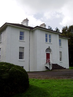
| Keale House | Keale South | Cullen | Millstreet | Keale 281 | Duhallow | Cork |
OSI Ref: W302 938
OS Sheet: 39 Discovery map: 79 |
|
Map of Estate Houses
Click on the markers to view more details about each house.
Contemporary printed sources
- LEWIS, Samuel. ''A Topographical Dictionary of Ireland''. London: S. Lewis & Co., 1837: I, 442
- LEET, Ambrose. ''A directory to the market towns, villages, gentlemen's seats, and other noted places in Ireland''. Dublin: Printed by B. Smith, 1814 : 224
- ''GRIFFITH'S VALUATION OF IRELAND'[Primary Valuation of Tenements]', 1850-1858. : Barony of Duhallow Part III, 7
- PARLIAMENTARY PAPERS. ''Return of owners of land of one acre and upwards, in the several counties .... in Ireland''. HC 1876, LXXX: 127
- HUSSEY DE BURGH, U. H. ''The Landowners of Ireland. An alphabetical list of the owners of estates of 500 acres or £500 valuation and upwards in Ireland''. Dublin: Hodges, Foster and Figgis, 1878. [available online at www.askaboutireland.ie] : 263
- TAYLOR, George & SKINNER, Andrew. ''Maps of the Roads of Ireland, surveyed in 1777 and corrected down to 1783''. Facsimile of 2nd edition. Shannon: Irish University Press, 1969: 182 (Kaile)