Drumraney
Houses within 5km of this house
Displaying 12 houses.
Houses within 5km of Drumraney
Displaying 12 houses.
| House name | Description | |
|---|---|---|
| Umma or Emoe House | Umma or Emoe House is named on the first edition OS map. It was a Magan home from at least the early 18th century. Thomas Magan was resident in 1814. O’Brien writes that Francis Magan was the last family member to reside at Emoe. It was recorded as his seat in 1837. He died in 1841. At the time of Griffith’s Valuation (publ. 1854) James Hill Shaw held the house valued at £15 from George A Boyd. Another building with the same name is marked on the 25 inch map to the south east of the original house and is still extant (N198 453). This second house was built in 1900 (O’Brien) by the Shaw family. James Shaw of Ballymahon purchased the lands in 1875. Occupied by the Skelly family in the 20th century. | |
| Gortmore [Longfield] House (Ballymahon) | Arthur H. Griffith was leasing this property from the King-Harman estate at the time of Griffiths Valuation in the early 1850s, when it was valued at almost £41. The house shown on the 1st edition Ordnance survey map is labelled Longfield House. The expanded range of buildings at the site, shown on the 25-inch map of the early 20th century, is labelled Gortmore House. O'Brien writes that Arthur Hill Griffith built this house c.1840 but that the Griffith family moved to Australia in 1871. He also notes that the previous house, known as Longfield, had been occupied by members of the Langstaff family. In 1837 Lewis referred to Longfield as the seat of J. Langstaff. Gortmore is no longer extant. | |
| Ardnagragh | Alicia Nugent was leasing this property, which included a mill, from the Digby estate at the time of Griffiths Valuation in the early 1850s, when it was valued at £23. The National Inventory of Architectural Heritage indicates that the house is still in use though the mill has been demolished. | |
| Newgrove [Badgersbridge House] (Ballymahon) | This property was held in fee by Dillon Kelly at the time of Griffiths Valuation, when it was valued at over £10. It is labelled Newgrove or Badgersbridge House on the 1st edition Ordnance Survey map but does not appear on subsequent maps. The Valuation Office books show that the house had been valued at £15 in 1840. | |
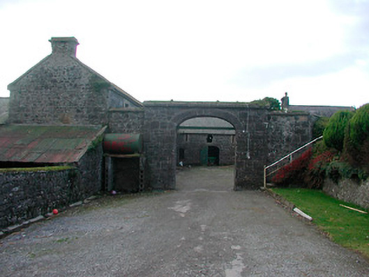
| Dorrington House | At the time of Griffiths Valuation St. George Gray held this property in fee when it was valued at £32. It is labelled Dorrington House on all editions of the Ordnance Survey maps. In 1906 it was the property of Wellington Gray and valued at £44. O'Brien writes that the house was demolished during the twentieth century and a newer house constructed at the site but extensive estate architecture survives. |
|
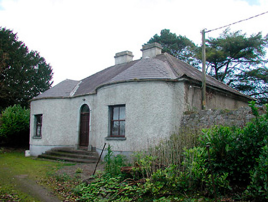
| Walderstown Lodge | William Potts was leasing this property from the Gray estate at the time of Griffiths Valuation in the early 1850s, when it was valued at £12. O'Brien writes that it was possibly built by the Dorrington Hackett family of nearby Dorrington House. It was acquired by the Gray family by inheritance and became a dower house. It is still extant. |
|
| Kilcornan Lodge (Ballymahon) | Thomas Murray was leasing this property from Charles Edward Grogan at the time of Griffiths Valuation in the early 1850s, when it was valued at almost £14. In 1814 Leet referred to Kilcornan as the residence of Patrick McDermott. O'Brien details the various occupiers from 1785, the year from which he asserts the house dates. It is still extant. | |
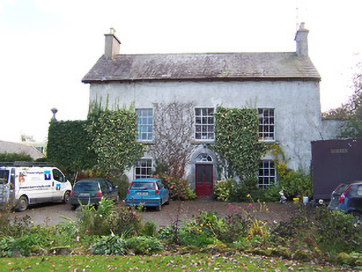
| Noughaval House (Ballymahon) | William Dawson was leasing this property from the King-Harman estate at the time of Griffiths Valuation in the early 1850s when it was valued at £13. Lewis also referred to it as his seat in 1837. The National Inventory of Architectural Heritage suggests it was built in 1760. O'Brien notes that there is a family tradition that the roof had to be replaced in the nineteenth century having been damaged during ''the Night of the Big Wind'' in 1839. Noughaval is still extant and occupied. |
|
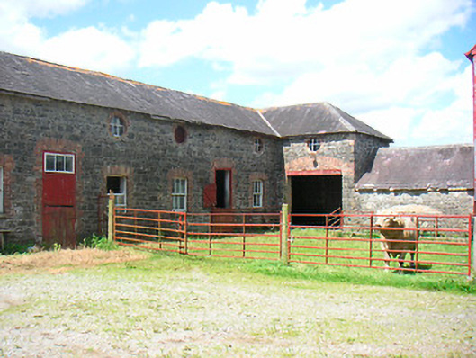
| Belmore Place | At the time of Griffiths Valuation in the early 1850s this property was held in fee by Robert W. Lowry, when it was valued at £16. It is labelled Belmore Place on all editions of the Ordnance Survey maps. O'Brien writes that the original house at this site had been occupied by Netterville Blake, who sold the property to Lowry in 1832. The National Inventory of Architectural Heritage suggests the surviving farm complex was built c.1850. The house was demolished in the 20th century. |
|
| Ballymore Parochial House | Thomas Coffey was leasing this property to Reverend Thomas Guinan at the time of Griffiths Valuation when it was valued at £12. A smaller house appears at this location on the 1st edition map of 1838 but a house labelled “Parochial House” is shown on the early 20th century 25-inch edition. Buildings still extant at site but may not be original. | |
| Lissanode House | O'Brien writes that this house was occupied by the Russell family, probably from the early part of the eighteenth century. At the time of Griffiths Valuation, in 1854, it was occupied by Frederick W. Russell, leasing from the Boyd estate, when it had a valuation of £7. It was replaced by a more substantial house in the late nineteenth century following a fire. It is still extant. | |
| Lissaquill House | In 1837 Lewis referred to Lissaquill House as the seat of Harding Fetherstone. At the time of Griffiths Valuation in 1854 this property was occupied by John Hogan, leasing from O'Brien Dillons, when it was valued at £9. The Valuation Office Books of 1841 noted the house here as having a valuation of £10 and occupied by Harding Fetherstone. A house and farm are still extant at this location. |