Carlanstown
Houses within 5km of this house
Displaying 8 houses.
Houses within 5km of Carlanstown
Displaying 8 houses.
| House name | Description | |
|---|---|---|
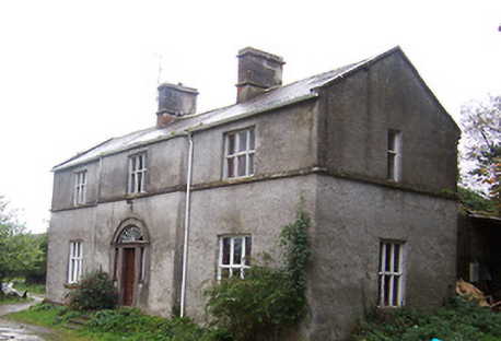
| Gore Port [Derrymacegan] | In the 1850s Captain Alexander Walker was leasing this property from the Gore estate when it was valued at £15. It is labelled Derrymacegan on the 1st edition OS map but as Gore Port on subsequent editions. The National Inventory of Architectural Heritage suggests the earlier part of the property dates from the mid 18th century and the later part from the early 19th century. O'Brien suggests that it was Captain Walker who built the later building, c.1835. Sir Samuel Walker, Lord Chancellor of Ireland, 1892-95, was born at Gort Port in 1832. The house is still extant. | |
| Annis Grove | This property was valued at almost £10 at the time of Griffiths Valuation in the early 1850s when it was leased by Patrick Lynch from the Gore estate. O'Brien states that it was occupied by the Lynch family from at least the early nineteenth until the last quarter of the twentieth century. He indicates that it was originally known as Money, from the townland in which it is situated. It is now a ruin. | |
| Tullystown | At the time of Griffiths Valuation in the early 1850s James McCullagh was leasing this property from the Duke of Buckingham’s estate when it was valued at £11. It was still in the McCullough family in 1906 with the same valuation. O'Brien records that Tullystown was damaged by fire in 2013 and gives an account of the various buildings that have existed at this site. |
|
| Gaulstown House (Fore) | The National Inventory of Architectural Heritage suggests this house was built about 1730. At the time of Griffiths Valuation it was occupied by Andrew Mulligan, leasing from Hubert de Burgh’s estate, when it was valued at £21. It had previously been the seat of the Lill family who had succeeded to de Burgh property and adopted that surname. The house is labelled Gaulstown on the 25-inch Ordnance Survey map. It is still extant. |
|
| Castletown Cottage | At the time of Griffiths Valuation this property was held in fee by Samuel Reynell when it was valued at almost £8. O'Brien suggests that the original property was built c.1840. The National Inventory of Architectural Heritage indicates it was extended in the mid C19. The Valuation Office books of 1841 noted a house valued at almost £7 in this townland, then occupied by James Campbell. The house is labelled Castletown Cottage on the 25-inch edition OS map of the early C20. It is still extant and in use. |
|
| Lickbla House [ Rockbrook](Fore) | Thomas Fagan was leasing this property from James Fallon at the time of Griffiths Valuation in the early 1850s when it was valued at almost £19 and included a mill. In 1906 it was the property of Patrick J. Fagan and valued at almost £21. The National Inventory of Architectural Heritage suggests that it dates from c.1800 but with later modifications. It is labelled Rockbrook on the 1st edition OS map but as Lickbla House on later editions and is still extant and occupied. |
](https://landedestates.ie/storage/img/orig/3618.png)
|
| Newcastle (Fore) | Walter Keating was occupying Newcastle at the time of Griffiths Valuation in the early 1850s when it was leased from the Urquhart estate and valued at £19. In 1839 the Valuation Office Books indicate that George Keating was the occupier with a valuation of £23. It is still extant. | |
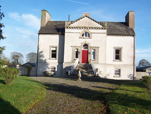
| Turbotstown [Turbotstown House] | The National Inventory of Architectural Heritage suggests that the present house at Turbotstown was built in the early decades of the nineteenth century, on the site of an earlier house. At the time of Griffiths Valuation in the early 1850s it was held in fee by Gerald Dease when the buildings were valued at £80. In 1906 it was still the property of Major Gerald Dease and valued at £84. It was occupied by the Dease family until the 20th century and is still extant. O'Brien provides a detailed account of this house and its occupants. On the 1st edition Ordnance Survey map it is labelled Turbotstown House but on the 25-inch edition of the early 20th century it is labelled Turbotston. |
![Photo of Turbotstown [Turbotstown House]](https://landedestates.ie/storage/img/orig/3616.png)
|