New Port (Ballymahon)
Houses within 5km of this house
Displaying 12 houses.
Houses within 5km of New Port (Ballymahon)
Displaying 12 houses.
| House name | Description | |
|---|---|---|
| Ballysallagh House | Ballysallagh house is not marked on first edition OS map. It is a three-bay two-storey late-Georgian-style farm house, built about 1850. At the time of Griffith’s Valuation (publ. 1854) it was occupied by Christina McCormick, who held the house valued at £11 from William Longworth. It is still in use as a residence. |
|
| Baronstown | Baronstown was a large mansion in an extensive demesne on the western shore of Lough Iron, as shown on the first OS map, with many features such as a temple, summer house etc. Described by the National Built Heritage Service as an important late eighteenth-century Palladian villa with two storey wings, it was associated with the Malone Family/Lord Sunderlin. Taylor and Skinner noted it as a Malone property in 1777. Lord Sunderlin was resident in 1814. Following the death of Richard Malone in 1837 his sister Alicia who had married Henry O’Connor of Mount Pleasant, King’s County (Offaly) succeeded to the Baronstown and Shinglis estates. O’Brien writes that the building was burnt twice and rebuilt. The first time in 1889 and the second time in 1903 when it was replaced by a large Tudor villa to designs by James Franklin Fuller. In 1906 it was valued at £70 and was occupied by Colonel John R Malone who held it with 943 acres of untenanted land. Demolished by the Land Commission in the 1920s, it is now a greenfield site. |
|
| Oran Vale | Located directly north of Ballynacarrigy, Oran Vale is named on the first edition OS map and was occupied by J Irwin in 1837. Valued at £15 it was unoccupied at the time of Griffith’s Valuation (publ. 1854) while the immediate lessor was Thomas William West who held the property from Alicia O’Connor Malone. The house is not named on the 25 inch map and is now a ruin. | |
| Willybrook/Willifield | This house is named Willybrook on the first edition OS map and as Willifield on the 25 inch map. Valued at £12 at the time of Griffith’s Valuation (publ. 1854), it was occupied by Joseph Evers who held it from Alicia O’Connor Malone (in Chancery) and remains a well maintained residence. |
|
| Rath House | Rath House, was the home of J West in 1837 and of Thomas West at the time of Griffith’s Valuation (publ. 1854), when the buildings, including a corn mill, were valued at £34 and held from Alicia O’Connor Malone. In 1906 the mansion house of Rath valued at £30 was in the occupation of Colonel John R Malone and was held with 62 acres of untenanted land. The census records would suggest that the local rector Rev Venn was actually resident. The house is now demolished. | |
| Tristernagh House | Described as an imposing and dramatic ruin with an interesting and varied history Tristernagh was originally an important Augustinian Abbey, founded c. 1200 by Geoffrey de Costentin (boi). After the dissolution of the monasteries and abbeys it was granted to the Piers Family, Elizabethan settlers. In 1783 Sir William Pigot Piers turned part of the building into a residence, which is named as Tristernagh House on the first edition OS map. It was unoccupied in 1814. A new house/cottage was built to the north of the abbey in the early nineteenth-century which is marked on the first edition OS map (N332 616). It is not clear which of these houses Lewis is referring to as the seat of Sir John Piers Bt in 1837. The 25 inch map of the early 20th century named this later building as Tristeragh House, while the original Tristeragh House at the abbey site was a ruin. Woods writes that the ‘late J Eivers Esq, J.P., lived for years in the cottage built by the late Sir John Piers’ while the mansion built by Sir Pigot William Piers in 1783 was ‘a crumbling ruin’. At the time of Griffith’s Valuation (publ. 1854) James Evers was recorded as the occupant of a house at Tristernagh valued at £10 held from Hamilton Geale. Shepherd Patrick Garry with family members was living here in 1901 and 1911. They held the house from Colonel John R Malone. The house is still extant. |
|
| Rockfield/Cromlyn | A house known as Rockfield (N295657) is named on the first edition OS map at the southern end of Glen Lough. The lands and house were leased to John Crawford by Sir Peter Nugent in 1795. Matthew Crawford was resident in 1814. A later house a short distance to the east was built by the Crawfords in the late 1840s according to the sale rental of 2 December 1862, ‘The house, which is a spacious and well-built mansion erected within the last fifteen years at an expense of upwards of £2,000 … The house contains on the basement-story nine rooms, including kitchen, wine-cellar, scullery etc with every accommodation for servants. There are on the first floor four large reception-rooms, one dressing room, two pantries, bath-room etc. On the second floor, seven commodious and well-proportioned sleeping apartments besides bathrooms etc.’ This house was originally known as Rockfield and was valued at £36 at the time of Griffith’s Valuation (publ. 1854) when occupied by Matthew Crawford. The name of the house may have been changed to ‘Cromlyn’ when it was purchased by Charles John Battersby of Ballinalack in 1862. It is named as Cromlyn on the 25 inch map (circa 1914). The house remained in the possession of the Battersby family well into the 20th century. |
|
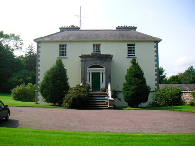
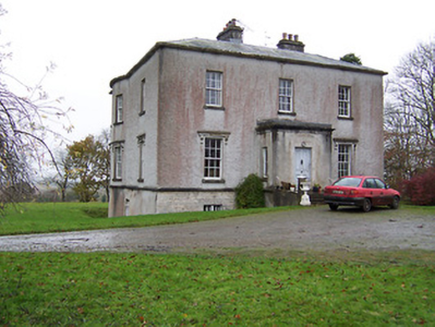
| Castlewilder [Cloghdoo House] | Richard P. O’Reilly, MD, held this property in fee at the time of Griffiths Valuation in the early 1850s, when it was valued at £30. On the 1st edition Ordnance Survey map it is labelled Cloghdoo House but as Castlewilder on the 25-inch edition of the early 20th century. The Ordnance Survey Name Books note that the townland at that time (1835) was the property of Mr. Wilder. In 1814 Leet referred to 'Castlewilden' as the seat of John Mangan. The National Built Heritage Service suggests the house and its complex of estate buildings was built in the 18th century but modified in the 1880s. |
![Photo of Castlewilder [Cloghdoo House]](https://landedestates.ie/storage/img/orig/3403.png)
|
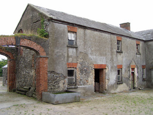
| Foxhall (Ballymahon) | Richard M. Fox held this property in fee at the time of Griffiths Valuation in the 1850s, when it was valued at £40. The original valuation also noted it as his property in 1839 with a valuation of £39. In 1906 it was owned by the representatives of R.E. Fox. The Ordnance Survey Name Books mention that the demesne contained 38 acres of woodland in the mid-1830s. Leet referred to it as the residence of Richard Fox in 1814. The National Built Heritage Service suggests that the house at Foxhall was demolished in 1946. Estate architecture, including the stables, survives |
|
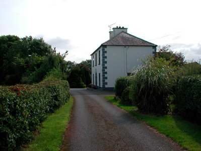
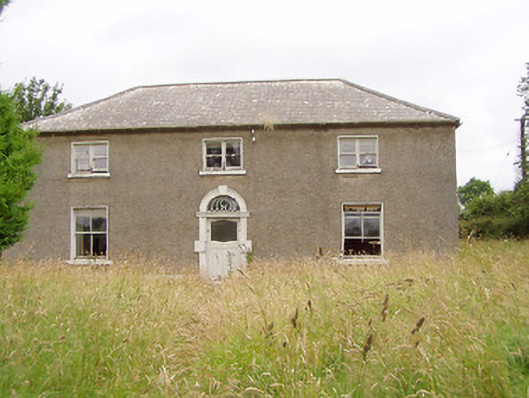
| Newtown House [Newtown Lodge] | Robert Hagerty was leasing this property from the Fox estate at the time of Griffiths Valuation in the early 1850s. The house at the site is labelled Newtown Lodge on the 1st edition Ordnance Survey map. The Ordnance Survey Name Books referred to this as a 'farm house' in the 1830s. A different house at the site is named as Newtown House on the later editions, the name by which it is still known. The National Built Heritage Service suggests the original house was built c.1810. It is extant and well-maintained. |
![Photo of Newtown House [Newtown Lodge]](https://landedestates.ie/storage/img/orig/3406.png)
|
| Treel House | William Atkinson was occupying Treel House at the time of Griffiths Valuation in the 1850s, when it and the adjacent mill were valued at £28. The National Built Heritage Service suggests the house was built c.1830. In 1839 the original Valuation Books, however, stated that at that time no house in the townland had a valuation of greater than £5 suggesting that Treel House was enlarged after that date. The Ordnance Survey Name Books noted in 1835 that the townland was then the property of Mr. Fox. Treel is still extant though not in use. |
|
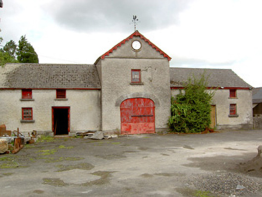
| Sunfield House | George Gamerson was leasing this property from the King Harman estate in the 1850s when it was valued at £12. The valuers' original valuation, which also includes a description of all buildings on the site, was over £20. The house is not named on the 1st edition OS map but is labelled Sunfield House on the 25” ed. A substantial farm occupies the site including the original buildings |
|