Glenidan
Houses within 5km of this house
Displaying 7 houses.
Houses within 5km of Glenidan
Displaying 7 houses.
| House name | Description | |
|---|---|---|
| Archerstown House | Archerstown House, located on the shore of Archerstown Lough, is named on the first edition OS map with a police barrack at its front entrance. Also named on the 25 inch map but subsequently demolished. Archerstown was the home of John Maher in 1814 and of Robert Smyth in 1837. O’Brien records Thomas Smyth, ancestor of the Drumcree branch of the family, living at Archerstown in 1671. Samuel Arthur Reynell held the house valued at £50 from Robert Smyth at the time of Griffith’s Valuation (publ. 1854). He was agent to the Marquess of Westmeath and became Master of the Westmeath Hunt. The Reynells continued to live at Archerstown until the 1940s when it was sold. Acquired by the Land Commission in the 1960s the house was demolished. | |
| New Archerstown | This house is marked on the first edition OS map. The outbuildings were considerably extended by the time of the 25 inch map. Valued at £15 at the time of Griffith’s Valuation (publ. 1854), it was occupied by Thomas W Donaldson and held from Robert Smyth. Mrs Jane Crawford and her son lived here in 1901 and 1911. A building still occupies the site. | |
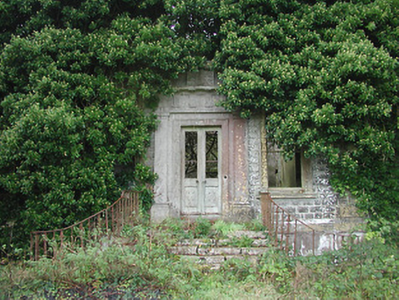
| Drumcree | Drumcree House was a seven-bay two-storey over basement Palladian country house, built in the mid-18th century for a branch of the Smyth family. In 1814 William Smyth was resident. By 1837 his son Robert occupied the house and Griffith’s Valuation (publ. 1854) records Robert Smyth holding the house in fee. It was valued at £60. By the early 20th century Henry Maxwell Smyth had inherited the property. He was there in 1906 when the valuation had increased to £75. O’Brien writes that the house was abandoned after the death of H M Smyth in 1961 and is now an ivy clad ruin. |
|
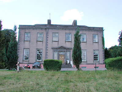
| Glananea/Ralphsdale | Glananea House, formerly Ralphsdale, as it is named on the first edition OS map, with laid out gardens immediately to the back of the house. This two-storey six-bay late 18th century house was built to the design of Samuel Wooley for Ralph Smyth, second son of William Smyth of Drumcree. Ralph’s son William Thomas inhabited the house in 1814 and was succeeded by his son another Ralph, who was resident in 1837 when Lewis recorded that his demesne is ‘entered by a beautiful gate’, which is now at Rosmead. At the time of Griffith’s Valuation (publ. 1854) the house was valued at £50 when occupied by William Edward Smyth who held it from Robert Smyth (of Drumcree). The Smyth family were resident in 1901 but a caretaker occupied the house in 1911. Glananea remains a private residence. |
|
| Sallymount House | Sallymount House is a three-bay two-storey house with dormer attic, dating from the early 19th century. It was the home of the Rotheram family for much of the 19th and 20th centuries. The Rotherams acquired it from the Nugent family. G S Rotheram was resident in 1837 and Griffith’s Valuation (publ. 1854) records George Rothram as the occupant holding the house valued at £35 from Priscilla Nugent. Members of the Rotheram family owned 560 acres in the 1870s. The estate was acquired by the Land Commission in the early 1960s and the house became derelict but has been restored recently. | |
| Lough Bawn | Lough Bawn House, Carrick, a two-storey, four-bay house built c 1840s as it is not marked on the first edition OS map. It was the home of the Battersby family. George Battersby held it in fee at the time of Griffith’s Valuation (publ. 1854) when the building was valued at £28.5. John Radcliff Battersby, JP and farmer, and family were resident at the beginning of the 20th century and the house remains in the possession of Battersby descendants, see https://landedfamilies.blogspot.com/2021/06/459-battersby-of-bobsville-lakefield.html |

|
| Cummerstown House | Cummerstown House, a two-storey, three-bay house, not built at the time of the first edition OS map but named on the 25 inch. Occupied by Laurence Levey at the time of Griffith’s Valuation (publ. 1854) when the building was valued at £10.10 and held from the trustees of Wilson’s Hospital. Home of farmer Samuel O’Neill and family at the beginning of the 20th century, now the address of Cummerstown Farm Aviation Ltd. |