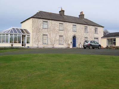
Ballyknock House
Houses within 5km of this house
Displaying 12 houses.
Houses within 5km of Ballyknock House
Displaying 12 houses.
| House name | Description | |
|---|---|---|
| Martinstown | Martinstown is marked on the first edition OS map but is named on the later 25 inch map. It was built c.1820, on a L-shaped plan with two-storey return to the rear (boi). John Kerr held most of this townland from Thomas R Evans at this time and occupied the house valued at £12. Other Kerr family members occupied houses valued at £7 and £8.10. |
|
| Derry Cottage/Drumcree Cottage | Drumcree Cottage (also known as Derry Cottage) is named on the first edition OS map. Lewis records Derry Cottage as the home of Mrs Berry in 1837. Griffith’s Valuation (publ. 1854) records Letitia C Berry (nee Smyth) as resident in a house valued at £20 and held from Robert Smyth. A building still stands on the site. | |
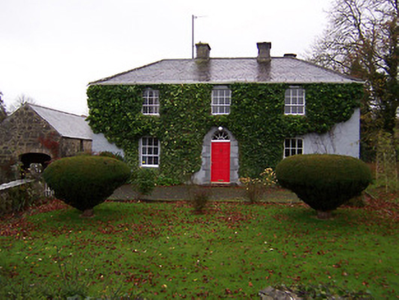
| Drumcree | Drumcree House was a seven-bay two-storey over basement Palladian country house, built in the mid-18th century for a branch of the Smyth family. In 1814 William Smyth was resident. By 1837 his son Robert occupied the house and Griffith’s Valuation (publ. 1854) records Robert Smyth holding the house in fee. It was valued at £60. By the early 20th century Henry Maxwell Smyth had inherited the property. He was there in 1906 when the valuation had increased to £75. O’Brien writes that the house was abandoned after the death of H M Smyth in 1961 and is now an ivy clad ruin. |
|
| Glananea/Ralphsdale | Glananea House, formerly Ralphsdale, as it is named on the first edition OS map, with laid out gardens immediately to the back of the house. This two-storey six-bay late 18th century house was built to the design of Samuel Wooley for Ralph Smyth, second son of William Smyth of Drumcree. Ralph’s son William Thomas inhabited the house in 1814 and was succeeded by his son another Ralph, who was resident in 1837 when Lewis recorded that his demesne is ‘entered by a beautiful gate’, which is now at Rosmead. At the time of Griffith’s Valuation (publ. 1854) the house was valued at £50 when occupied by William Edward Smyth who held it from Robert Smyth (of Drumcree). The Smyth family were resident in 1901 but a caretaker occupied the house in 1911. Glananea remains a private residence. |
|
| Gigginstown House | The original house, Gigginstown Lodge, was a Dardis home and is marked on the first edition OS map. It was occupied by Christopher Dardis in 1814 and Captain Brabazon O’Connor in 1837, who had married the widow of Michael Dardis. It is no longer extant (N528 615). Gigginstown House is described by O’Brien as ‘a two-storey, three-bay classical house designed by John S Mulvany’ built in the mid-1850s on a new site and recorded as unfinished at the time of Griffith’s Valuation (publ. 1854). Valued at £40, Elizabeth Busby was the occupant holding the house in fee. The property had been bought on her behalf and that of her sister in 1828. Alphonso Busby owned 1,408 at Gigginstown in the 1870s. James Taylor, farmer and his wife Kate were resident in the early 20th century. A stud and farm are now located at Gigginstown House, owned by Michael O’Leary, see https://www.gigginstownhouse.com/wp/ |
|
| Gartlandstown House | Gartlandstown House, located at the south eastern toe of Lough Derravargh, is a five-bay two-storey house, built about 1830 (boi) or perhaps replacing an earlier house as Garlandstown, Castlepollard, was the seat of Sterne Tighe in 1814. By 1837 J Murray was resident here and James Murray is recorded as the occupant at the time of Griffith’s Valuation (publ. 1854) when the house was valued at £10 and held from James W M Berry. O’Brien writes that Michael Hope was resident in 1869 and in the mid-1870s the representatives of Michael Hope held 487 acres at Gartlandstown. Members of the Hope family was still in occupation at the time of the 1901 and 1911 censuses. |
|
| Clondalever House | Clondalever House is marked on the first edition OS map, but expanded and named on the 25 inch map. At the time of Griffith’s Valuation (publ. 1854) it was valued at £14, occupied by Edward Hope, who held it from George W Mansell or Maunsell (Oakley Park). A house is still located on this site. | |
| Streamstown House | Streamstown House, located on the eastern shore of Lough Derravargh, is a five-bay two-storey house, built about 1800. At the time of Griffith’s Valuation (publ. 1854) it was occupied by Thaddeus Lynch, valued at £11 and held from Benjamin Chapman. Michael Hope, JP and farmer, and family were resident here in 1901 and his widow Eliza and family in 1911. |
|
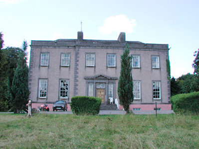
| Barbavilla | Barbavilla House is shown on the first edition OS map as situated in a large demesne with laid out gardens close to the house. It is a nine-bay two-storey over basement house, originally built by William Smyth in 1730. Smyth named the house after his wife Barbara Ingoldsby. The house was later altered by his grandson William Smyth in 1790. In the mid-19th century the house was valued at £72 and held in fee by William B Smyth. In 1906 William Lyster Smyth was the occupant when the buildings were valued at £58.5 and held with 434 acres of untenanted land. The Smyths sold Barbavilla in 1955. The house is now surrounded by large buildings relating to the production of artisan products for Barbavilla Dairy. |
|
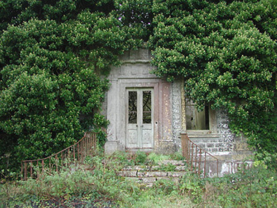
| Benison Lodge | Benison Lodge, west of Lough Lene, is named on both the first edition six inch and 25 inch OS maps. O’Brien describes it as a late 18th century, five-bay, two-storey house, probably by the O’Reilly family, one of whom was shot dead in the house in 1803 by the coachman. In 1814 Thomas H Smyth lived here and the Rev T Smyth in 1837. By the time of Griffith’s Valuation (publ. 1854) John Henry Roper was occupying the house, valued at £30 and held from William P Urquhart of Castlepollard. In the 1870s Henry J Roper of Benison Lodge owned 447 acres. In the early 20th century Richard O’Neill and family were living in a first class house in this townland. The house is now a ruin. | |
| Gillardstown | Gillardstown is named on both the first edition six inch and 25 inch OS maps. A Mrs Scully was living at Gillerstown, Castlepollard, in 1814. At the time of Griffith’s Valuation (publ. 1854) Thomas Webb occupied the house, valued at £25 and held from Robert A Ellis. The house was the home of William Evans, a Civil Engineer and Law Agent, and his family in 1901 and of William Hardy, a farmer and his wife in 1911. The house is now the centre of a farming complex. | |
| Loughpark | Lough Park House, situated on the shores of Lough Lene to the south east of Castlepollard, this five-bay two-storey house, built about 1790 was home to the Evans family for much of the 19th century. N Evans was resident in 1837 and Michael Evans at the time of Griffith’s Valuation (publ. 1854). He held the house valued at £20 from William P Urquhart of Castlepollard. Thomas Pender, farmer and family lived here in 1901 and Samuel R Sutton, farmer and family in 1911. The property remains a family home. |
|