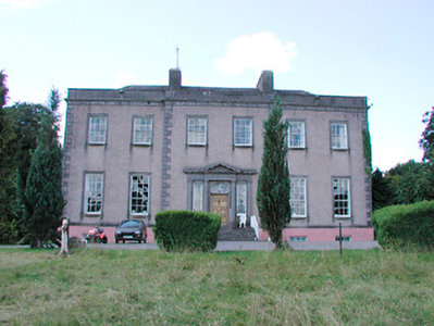
Drumcree
Houses within 5km of this house
Displaying 10 houses.
Houses within 5km of Drumcree
Displaying 10 houses.
| House name | Description | |
|---|---|---|
| Derry Cottage/Drumcree Cottage | Drumcree Cottage (also known as Derry Cottage) is named on the first edition OS map. Lewis records Derry Cottage as the home of Mrs Berry in 1837. Griffith’s Valuation (publ. 1854) records Letitia C Berry (nee Smyth) as resident in a house valued at £20 and held from Robert Smyth. A building still stands on the site. | |
| Glananea/Ralphsdale | Glananea House, formerly Ralphsdale, as it is named on the first edition OS map, with laid out gardens immediately to the back of the house. This two-storey six-bay late 18th century house was built to the design of Samuel Wooley for Ralph Smyth, second son of William Smyth of Drumcree. Ralph’s son William Thomas inhabited the house in 1814 and was succeeded by his son another Ralph, who was resident in 1837 when Lewis recorded that his demesne is ‘entered by a beautiful gate’, which is now at Rosmead. At the time of Griffith’s Valuation (publ. 1854) the house was valued at £50 when occupied by William Edward Smyth who held it from Robert Smyth (of Drumcree). The Smyth family were resident in 1901 but a caretaker occupied the house in 1911. Glananea remains a private residence. |
|
| Gigginstown House | The original house, Gigginstown Lodge, was a Dardis home and is marked on the first edition OS map. It was occupied by Christopher Dardis in 1814 and Captain Brabazon O’Connor in 1837, who had married the widow of Michael Dardis. It is no longer extant (N528 615). Gigginstown House is described by O’Brien as ‘a two-storey, three-bay classical house designed by John S Mulvany’ built in the mid-1850s on a new site and recorded as unfinished at the time of Griffith’s Valuation (publ. 1854). Valued at £40, Elizabeth Busby was the occupant holding the house in fee. The property had been bought on her behalf and that of her sister in 1828. Alphonso Busby owned 1,408 at Gigginstown in the 1870s. James Taylor, farmer and his wife Kate were resident in the early 20th century. A stud and farm are now located at Gigginstown House, owned by Michael O’Leary, see https://www.gigginstownhouse.com/wp/ |
|
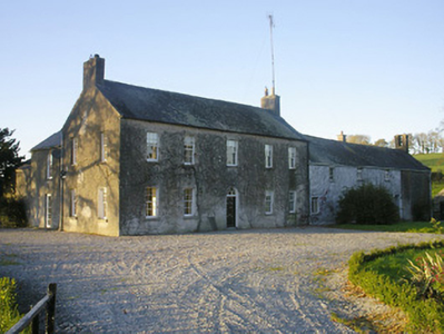
| Ballyknock House | Ballyknock House, Derrynagarragh, is marked on the first edition OS map at a road junction and named on the 25 inch map and appears to be extant. In 1814 Ballyknock was the residence of Richard McCormick. At the time of Griffith’s Valuation (publ. 1854) it was valued at £16.10, occupied by Catherine McCormick and held from Richard McCormick. It appears to have been located on the Berry estate. | |
| Clondalever House | Clondalever House is marked on the first edition OS map, but expanded and named on the 25 inch map. At the time of Griffith’s Valuation (publ. 1854) it was valued at £14, occupied by Edward Hope, who held it from George W Mansell or Maunsell (Oakley Park). A house is still located on this site. | |
| Streamstown House | Streamstown House, located on the eastern shore of Lough Derravargh, is a five-bay two-storey house, built about 1800. At the time of Griffith’s Valuation (publ. 1854) it was occupied by Thaddeus Lynch, valued at £11 and held from Benjamin Chapman. Michael Hope, JP and farmer, and family were resident here in 1901 and his widow Eliza and family in 1911. |
|
| Barbavilla | Barbavilla House is shown on the first edition OS map as situated in a large demesne with laid out gardens close to the house. It is a nine-bay two-storey over basement house, originally built by William Smyth in 1730. Smyth named the house after his wife Barbara Ingoldsby. The house was later altered by his grandson William Smyth in 1790. In the mid-19th century the house was valued at £72 and held in fee by William B Smyth. In 1906 William Lyster Smyth was the occupant when the buildings were valued at £58.5 and held with 434 acres of untenanted land. The Smyths sold Barbavilla in 1955. The house is now surrounded by large buildings relating to the production of artisan products for Barbavilla Dairy. |
|
| Lough Bawn | Lough Bawn House, Carrick, a two-storey, four-bay house built c 1840s as it is not marked on the first edition OS map. It was the home of the Battersby family. George Battersby held it in fee at the time of Griffith’s Valuation (publ. 1854) when the building was valued at £28.5. John Radcliff Battersby, JP and farmer, and family were resident at the beginning of the 20th century and the house remains in the possession of Battersby descendants, see https://landedfamilies.blogspot.com/2021/06/459-battersby-of-bobsville-lakefield.html |

|
| Cummerstown House | Cummerstown House, a two-storey, three-bay house, not built at the time of the first edition OS map but named on the 25 inch. Occupied by Laurence Levey at the time of Griffith’s Valuation (publ. 1854) when the building was valued at £10.10 and held from the trustees of Wilson’s Hospital. Home of farmer Samuel O’Neill and family at the beginning of the 20th century, now the address of Cummerstown Farm Aviation Ltd. | |
| Glenidan | Glenidan House is named on both the first edition six inch and 25 inch OS maps. Stephen Moore lived at Glenidan in 1814. Lewis records it as the residence of Blandford. Robert McCormick held Glenidan, valued at £10.10 from Patrick E Murphy at the time of Griffith’s Valuation (publ. 1854). This house appears to be still extant. |