Clonmaskill
Houses within 5km of this house
Displaying 10 houses.
Houses within 5km of Clonmaskill
Displaying 10 houses.
| House name | Description | |
|---|---|---|
| Addinstown | Addinstown House is named on the 25 inch map and was built post the composition of the first edition OS map circa 1838. At the time of Griffith’s Valuation (publ. 1854) it was valued at £10, occupied by Henry Smyth and held from the Rt Hon W W F Tighe. Members of the Adamson family lived here from the later part of the 19th century to the 1960s when purchased by the Land Commission. This house is demolished. | |
| Ballyhealy House | Ballyhealy House was the home of the Batty family. O’Brien describes it as a two-storey, five-bay late 18th century building. Charles Batty was resident in 1814 and P Batty in 1837. At the time of Griffith’s Valuation (publ. 1854) William Barry Batty lived here, holding the house valued at £30 from the Rev Edward Batty. The Rev Edward Batty of Ballyhealy owned over 1,200 acres in the 1870s. Espine Batty, JP, farmer and barrister was resident in 1901 and in 1906 but by 1911 Lt Claud O’Hagan and family lived here holding the property from the Battys. The house is now a ruin. | |
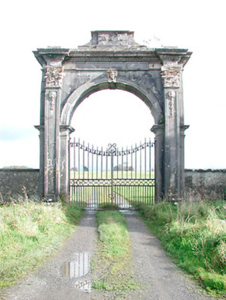
| Rosmead House | Rosmead House was set in an extensive demesne as shown on the first edition OS map. This was a seven-bay three-storey over basement mansion built in the late 18th century by Hans Widman Wood (1720-95). His eldest daughter Frances Elizabeth, wife of Admiral Hercules Robinson inherited the house. The Rosmead estate was sold by the Robinsons to Lord Vaux in 1852, when the house was described as an ‘imposing edifice’. In July 1879 it was for sale again and the Marquess de la Bedoyere who married Mildred, daughter of Lord Greville, came into possession. The 1879 sale rental gives descriptive details of the features of the house including the number of rooms and their dimensions and there is also a lithograph of the house. The Marquess was still occupying the mansion house, valued at £49.10 in 1906. It is now a ruin although the courtyard and entrance gate survive. |
|
| Clonyn House | Clonyn/Clonin House, (also known as Clonyn or Delvin Castle) is named on the first edition OS map with a riding school to the rear and is recorded as ‘in ruins’ on the 25 inch map. A plaque with the crest of the Nugent family on the façade dates the building 1680. Later extensions to the house dating from the early 18th century to the early 19th century are evident. This was the home of the Earls and Marquess of Westmeath and in 1837 is described as such by Lewis. The first and only Marquess of Westmeath died in 1871 and his estates were inherited by his daughter Rosa, who was married to Lord Greville. However, by the time of Griffith’s Valuation (publ. 1854) Lord Greville was already in possession of Clonyn holding it in fee and valued at £60. By 1906 the buildings were valued at £130.3 and held with 824 acres of untenanted land however the estate was ‘In Chancery’. The Hon Priscilla Nugent was the occupant. The house became a ruin some years later and is now surrounded by Delvin Golf course. | |
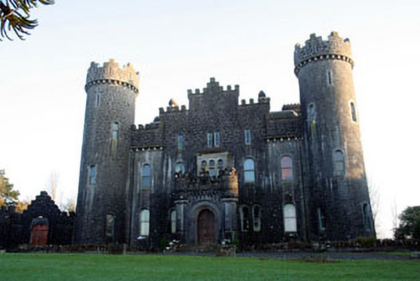
| Clonyn Castle | Clonyn Castle, five-bay two-and three-storey over basement Gothic Revival-style castle, built between 1867-1876 to the design of John McCurdy (1823-85) for Lord and Lady Greville-Nugent, both of whom died in 1883. Their sons followed careers in England and Australia and the house was only occupied by servants at the time of the 1901 census. Sold by the Grevilles in the 1920s this building remains a private residence. |
|
| Mitchelstown | Mitchelstown House was a home of the Tighe family in the early 19th century. Robert S Tighe was the occupant in 1814. Home of G Hinds in 1837 and at the time of Griffith’s Valuation (publ. 1854) of Captain John Roden who held the house, valued at £24 from Robert Howard. The house appears to be a ruin on the 25 inch map. | |
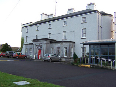
| Southhill | Southhill, a five-bay three-storey over basement country house, built about 1810 (boi). South Hill was originally the home of the Tighe Family. In 1814 Major Robert Tighe was occupying Southhill. By 1837 it had passed into the ownership of William Chapman, a younger son of Sir Thomas Chapman 2nd Bt of Killua Castle and grandfather of ‘Lawrence of Arabia’. He held the house in fee at the time of Griffith’s Valuation (publ. 1854) when it was valued at £41.15. In 1906, Francis V Chapman was recorded as the occupier but by 1911, Peter P Metge, a civil engineer and farmer, was resident with his family. This house has been a convent, hospital and is now the home of St Mary’s Special School. |
|
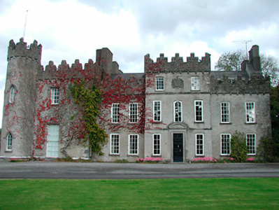
| Ballinlough Castle | Ballinlough Castle, a seven-bay two-storey over basement country house, encompassing a Medieval tower house. This has been the home of the O’Reillys and their descendants, the Nugents, for over four centuries. It has undergone many alterations including some in the late 18th century and was restored in the 1940s. Hugh O’Reilly, born in 1741, was created a baronet in 1795. He changed his name to Nugent in 1812 on inheriting the estates of his uncle John Nugent of Tullaghan. At the time of Griffith’s Valuation (publ. 1854) the house was valued at £67.10. It was noted by Slater as the seat of Lady Nugent in 1894. The Nugents continue to live at Ballinlough. O’Brien describes it as ‘one of the great showpieces of the Irish Midlands’. |
|
| Heathstown House | Heathstown House is a three-bay two-storey over basement house, built in 1834, as displayed on a weather vane on the roof, for the Dyas family. W Dyer was resident in 1837 and Richard Dyas at the time of Griffith’s Valuation (publ. 1854), when the house was valued at £19.5 and was held in fee. Richard’s son Jacob owned 793 acres in the 1870s and the Dyas family were still in possession in the early years of the 20th century. |

|
| Sallyview | Sallyview is mentioned in The Parliamentary Gazetteer of 1846 but no occupant is given. The building is marked on the first edition OS map and named Sallyview although altered in shape on the 25 inch map. Valued at £14.10 at the time of Griffith’s Valuation (publ. 1854), occupied by John and Christopher Plunkett and held from Michael Plunkett, now a green field site. |