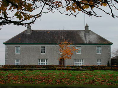
Meeldrum
Houses within 5km of this house
Displaying 6 houses.
Houses within 5km of Meeldrum
Displaying 6 houses.
| House name | Description | |
|---|---|---|
| Ballinlaban | Buildings are marked at this site on the first edition OS map, now an extensive farming complex. At the time of Griffith’s Valuation (publ. 1854) a house valued at £18 was occupied by William Colgan who held the property from the representatives of Sir Richard Nagle. | |
| Temple House | Temple House, Templemacateer, is located on an old abbey site and very close to the border with County Offaly, it is named on the first edition OS map. This three-bay two-storey house was built in the mid-18th century and altered c.1840 (boi). It was originally the home of the Handy family. Dennis Kelly was the occupant in 1814. Marcus Kelly was resident in 1837 and at the time of Griffith’s Valuation (publ. 1854) when the house was valued at £12 and held from the representatives of Samuel B Handy. It was the home of John Mark Kelly, a farmer, magistrate and land commissioner and his wife in 1901. Now in use as a guesthouse run by the Fagan family, see https://templemacateer.booking.site/en | |
| Ballard | Ballard House, named on the first edition OS map as Lauree, but on the 25 inch as Ballard, located to the south west of Kilbeggan. It is a five-bay two-storey over basement house, built or rebuilt about 1830 (boi). In 1814 W Battersby was resident and in 1837 R Bolger. By the time of Griffith’s Valuation (publ. 1854) Sylvester Lalor occupied the house valued at £10 from Dr Richard P O’Reilly. The Lalor family still live at Ballard where they run an organic farm. |
|
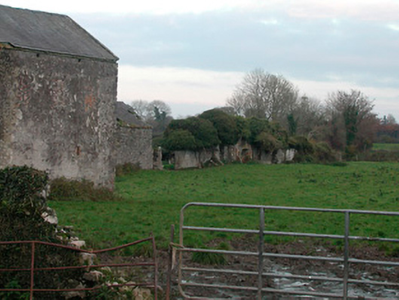
| Bracca Castle/Coolalough House | Coolalough House, also known as Bracca Castle, close to the village of Horseleap is named on both the first six inch and 25 inch OS maps as Coolalough. The first edition six inch map shows a castle in the townland. The estate was granted to the Handy Family in the mid-seventeenth century. Coolalough House was later a base for the Methodists in the area. Wesley records in his letters in 1785 that the Handy Family had recently built a new property at Coolalough, apparently (re)named Bracca Castle (boi). Samuel W Handy was occupying Bracca Castle in 1814 and Samuel Handy is listed as the owner of Bracca Castle in 1837. By the time of Griffith’s Valuation (publ. 1854) Joseph Hackett was occupying the house, valued at £10 and held from the representatives of Samuel W Handy. Home of Katherina Lett, a married lady, and two servants in 1911. This house is no longer extant, a green field site. |
|
| Moycashel | Located on a side road south west of Kilbeggan, Moycashel was the home of the Holmes family from the mid-19th century. It is not marked on the first edition OS map. At the time of Griffith’s Valuation (publ. 1854) Robert Holmes held the house valued at £16.10 in fee. It appears to have been occupied by William Serviss and family in 1901. A building remains on this site. |
|
| Bellmount/Belmont | Bellmount or Belmont, Hallsfarm, is named on both the first edition six inch OS and the 25 inch maps. O’Brien describes it as a three-bay, two-storey house over a basement erected about 1825 by the Maguire family. In 1837 Barnard Maguire was resident. Ellen Maguire occupied the house at the time of Griffith’s Valuation (publ. 1854) when it was valued at £11.10 and held from Col William Hall. The censuses of 1901 and 1911 record Eugene Gannon, a 26 year old farmer, born in Argentina, as resident in a first class house while in 1911 Joseph Delaney, herdsman and family were in occupation. This house is still a family home. |
|