Lakefield/Keoltown House
Houses within 5km of this house
Displaying 17 houses.
Houses within 5km of Lakefield/Keoltown House
Displaying 17 houses.
| House name | Description | |
|---|---|---|
| Jamestown House | Jamestown House was not built at the time of the first edition OS map. Situated on the main Mullingar to Athlone road the house, three-bay two-storey over basement house, was occupied by James Brabazon at the time of Griffith’s Valuation (publ. 1854) when the building was valued at £12 and held from Walter McK Bond. |
|
| Barrettstown | Barrettstown House was not built at the time of the first edition OS map (c. 1837). It is located just south of the railway line. At the time of Griffith’s Valuation (publ. 1854) it was valued at £22 and occupied by Thomas Murray who held the property from John Savage Nugent. Still occupied by the Murray family in 1911, this house is extant. |
|
| Dysart House | Dysart House was in ruins at the time the first edition OS map was compiled in the 1830s The Nugent family were resident here in the 18th century. Nugent of Desert is recorded on the Taylor and Skinner maps of the late 1770s. Lavallin Nugent born in 1722 died unmarried and the property was inherited by his brother John. When he died in 1812 it passed to his nephew Andrew Savage of Portaferry, Co Down who took the additional name of Nugent. Andrew Savage Nugent never lived at Dysart and it became a ruin. | |
| Lynn House | Lynn House, situated close to the shore of Lough Ennell, is named on the 25 inch map at this location. A house, offices, gatelodge and lodge were all held by Richard Swift MD in fee at the time of Griffith’s Valuation (publ. 1854), when they were valued at £12. A building remains on this site. | |
| La Mancha | La Mancha is situated facing Lough Ennell and named on the first edition OS map. This house was occupied by William Wynne in 1814 and was the property of Richard Swift in 1837, who held it in fee and valued at £18 at the time of Griffith’s Valuation (publ. 1854). This house is still extant. |
|
| Bloomfield | Bloomfield is named on the first edition OS map, situated close to the shore of Lough Ennell, it is now a hotel and leisure centre. O’Brien writes that the house was a long low two-storey nine-bay building now greatly altered. It was most likely built by the widow of the 2nd Earl of Belvedere after her marriage to Abraham Boyd in 1815. In 1837 Lewis records the Countess of Belvedere as the proprietor. Purchased [or leased] by Col John Caulfield of Benown/Harmony Hall in 1842 from George A Boyd who had inherited it from his mother. At the time of Griffith’s Valuation (publ. 1854) Col Caulfeild was the occupant holding the house valued at £40 from George A Boyd. Purchased by Charles B Marlay later in the 19th century. Functioned as a military hospital and convent in the 20th century until it became a hotel in the 1980s. | |
| Lynnbury | Lynnbury, situated near the shore of Lough Ennell, is named on first edition OS map. It is a two-storey, three-bay late 18th century house building, home of Thomas Swift who married Frances Dennis. He died in 1803 and was succeeded by his eldest son Rev Meade Swift, (died 1837) who took the additional name of Dennis when he and his brother John inherited the estates of their uncle James Dennis, Lord Tracton (O’Brien). Richard Bourne resided in the house in 1837. At the time of Griffith’s Valuation (publ. 1854) the house was valued at £40, occupied by Captain Charles Wynne and held from Paul Meade Dennis. In 1906 Lynnbury, valued at £65 was occupied by Gustavus Rochfort Hyde, who held it with 83 acres of untenanted land, see Wade of Aughrim. This house has been restored in recent times. |
|
| Ennel Lodge/Fort William | Ennell Lodge, previously known as Fort William as shown on the first edition OS map. This is a three-bay two-storey over basement house, built about 1800. It was valued at £13 but unoccupied at the time of Griffith’s Valuation (publ. 1854). Eliza Dennis was the immediate lessor. |
|
| Belville Cottage | Belville Cottage, five-bay single-storey house, built about 1820, marked on the first edition OS map and named on the 25 inch map. At the time of Griffith’s Valuation (publ. 1854) it was occupied by Florence Mahony, held from Eliza Dennis and valued at £10. |
|
| Belvidere/Belvedere | Belvidere is situated close to the shore of Lough Ennell with a ruined castle to the north west. It is a five-bay two-storey over basement former country house or fishing lodge built in the mid-18th century to designs by Richard Castle for Robert Rochfort, who became 1st Earl of Belvedere in 1757. Not long afterwards Rochfort made Belvedere his main home in preference to Gaulstown. Belvedere later passed on to the Marlay Family and then to Lt Col Howard-Bury. This house is very much associated with the Jealous wall, a sham folly, built to the south about 1760 to block out the view of Rochfort or Tudenham, the home of the 1st Earl’s brother George. Following the death of the 2nd Earl of Belvedere in 1814 Belvedere was inherited by his sister Jane, Countess of Lanesborough and descended to her great grandson Charles Brinsley Marlay. It was valued at £37 at the time of Griffith’s Valuation (publ. 1854) when he was resident. It’s valuation had increased to £47 by 1906. Following his death in 1912 he left Belvedere to his cousin, leader of the 1921 Mount Everest expedition Col Charles Howard Bury. When he died in 1963 he left Belvedere to a friend Rex Beaumont who sold the house in 1981 to Westmeath County Council who have restored the house and demesne in recent times. The house and gardens are open to the public and have become a major visitor attraction. |
|
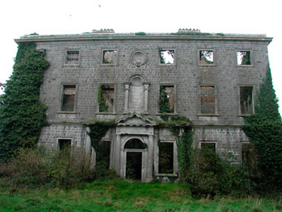
| Tudenham Park/Rochfort | Rochfort later known as Tudenham Park was a seven-bay three-storey over basement country house, built in the early 1740s for George Rochfort, a brother of Robert Rochfort of Belvedere House 1st Earl. Like Belvedere it was designed by Richard Castle but was a much larger edifice. In 1837 Lewis describes Col Rochfort seat as ‘one of the finest mansions in the county’. The house was sold about this time to Sir Francis Hopkins Bt. He was resident at the time of Griffith’s Valuation (publ. 1854) when the house was valued at £90. Following his death in 1860 the property passed to his sister Anna Maria Tottenham who changed its name to Tudenham. It remained in Tottenham ownership into the 20th century, Charles Loftus Tottenham being the occupant in 1906, holding it with 440 acres of untenanted land. Deroofed in the 1950s it is now a fine ruin. |
|
| Tallyho | Tallyho is a five-bay two-storey country house, built in the late 18th century by Thomas Gerard or possibly the Hon R Rochfort as Taylor and Skinner’s map of the late 1770s indicates he was resident there. Thomas Gerrard was resident in 1814 and it was the residence of Mrs. Gerard in 1837. Valued at £15 it was occupied by Michael Hevey who held it in fee. Agnes Duthie, a dairy teacher, lived here in 1901 and George Orr, a land steward and family in 1911 holding the property from J B Marley. This house is now the centre of a stud farm. |
|
| Charlestown House | Charlestown House, Balnamona, is named on both the first six inch and 25 inch maps. It was the home of Tennison Lyons in 1814. Hill J M Walsh was resident here at the time of Griffith’s Valuation (publ. 1854) when the house was valued at £15 and held from John C Lyons. There is a building still on the site, part of Charlestown stud. | |
| Bellmount House | Bellmount House, Curristown, is named on both the first six inch and 25 inch OS maps. It is a five-bay two-storey house, built about 1820. Although built on part of the Lyons of Ladestown estate, Bellmount House was in the possession of the Reilly family for most of the 19th century. The two families were related. In 1814 John Lyons is recorded as the occupier and in 1837 W Reilly. At the time of Griffith’s Valuation (publ. 1854) William Haig was resident holding the house valued at £36 from the representatives of Anthony A Reilly. Home of Arthur and Alice Trevor Booth in 1911. In the mid-20th century O’Brien records that Bellmount was in the ownership of the Gainsford-St Lawrence family of Howth Castle, Dublin. |
|
| Ladestown | Ladestown House, sometimes known as Ladytown or Ladystown, home of the Lyons family, was in existence when the Taylor and Skinner maps were compiled at the end of the 1770s but was rebuilt about 1823 as a five-bay two-storey over basement house. From 1814 to the 1850s, the author John Charles Lyons is recorded as the occupier. At the time of Griffith’s Valuation (publ. 1854) he held the property in fee and the house was valued at £44. The Lyons family continued to live at Ladestown in the early years of the 20th century. The house is now demolished but outbuildings survive which are home to a riding school. |
|
| Strokestown (Mullingar) | Stokestown, located beside the railway line and marked but not named on either the first six inch of 25 inch OS maps. At the time of Griffith’s Valuation (publ. 1854) the house was valued at £14, occupied by John McKeown and held from Lord Vaux. In September 1862 John McKeon was selling Stokestown and 145 acres in the Landed Estates Court, held under a lease from Lord Vaux, dated 6 August 1853. William Mullen, shepherd, and his family were living in a first class house in Stokestown in 1901, held from W H Middleton. A building remains on this site. | |
| Greenpark House | Greenpark House, previously known as Tuitestown, located south west of Mullingar, now a green field site. Members of the Hudson/Hodson family lived here as recorded on the Taylor and Skinner maps of the late 1770s when the property was known as Tuitestown and in Leet’s directory of 1814 when Hartley Hudson was resident at Greenpark. By the time of Griffith’s Valuation (publ. 1854) Elizabeth Connolly was occupying the house, valued at £28 and held from Sir George Hodson. |
|