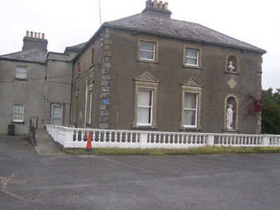
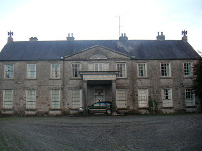
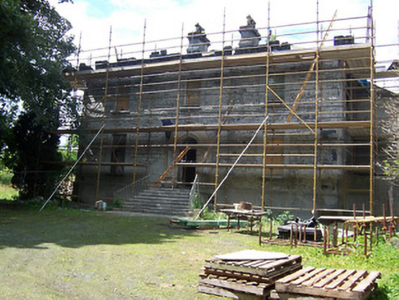
Rathconnell Court
Houses within 5km of this house
Displaying 12 houses.
Houses within 5km of Rathconnell Court
Displaying 12 houses.
| House name | Description | |
|---|---|---|
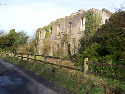
| Ballynagall | Ballynagall, a six-bay two-storey Regency style house, built in the early 19th century for James Gibbons at the cost of £30,000 (Lewis) and was reputedly built using the fabric of an existing castle on site, known as Castle Reynell (boi). Reynell of Castle Reynell is recorded on the Taylor and Skinner maps of the late 1770s. The interior plasterwork was executed by George Stapleton, son of the stuccadore Michael Stapleton. The Smyth Papers in the National Library contain letters to James Gibbons from John Robinson and Francis Johnston relating to the building of Ballynagall, 1810-1815 (Mss 18,926-18,927). Ballynagall remained in the possession of the Gibbons family until 1846 when ownership passed to James Middleton Berry, nephew of James Gibbons. At the time of Griffith’s Valuation (publ. 1854) the buildings were valued at £110 and held by JWM Berry in fee. Inherited by Thomas James Smyth of the Drumcree family in 1855, it remained in Smyth ownership until sold in 1963 (O’Brien). It is now a ruin. |
|
| Lynn Lodge | Lynn Lodge previously known as Lynn House, as named on the first edition OS map. A three-bay two-storey house, built early 19th century by the Swift family, possibly incorporating the fabric of an earlier structure. Jonathon Swift (1667-1747) wrote letters from Lynn House. Lynn the property of Swift Esq is recorded on the Taylor and Skinner maps of the late 1770s. It was the residence of Meade Swift in 1814. Lynn House was in the ownership of R. Swift and was the residence of the Rev. G. M. Dennis in 1837. By 1850 the house was known as Lynn Lodge and was occupied by Toriano L’Estrange when the interest of Richard Swift in the property, consisting of the house and about 100 acres was for sale in the Encumbered Estates Court. Valued at £23 at the time of Griffith’s Valuation (publ. 1854), occupied by John Cronin and held from Terence D Nolan. In 1906 Charlotte Swifte occupied a mansion house valued at £23 at Lynn which she held with 72 acres of untenanted land. This house is now the centre of a stud. |
|
| Cooksborough House | Cooksborough House is named on the first edition OS map but greatly altered by the time of the 25 inch map. The Cooke family were settled here from the 17th century. O’Brien writes that it was ‘a large rambling mainly Georgian house’. It was the home of many generations of the Cooke family. It is marked on the Taylor and Skinner map of the 1770s, Robert Cooke was resident in 1814 and Lewis refers to the ‘fine mansion of the Cooke family’ in 1837. The eccentric family member Adolphus Cooke lived here at the time of Griffith’s Valuation (publ. 1854), holding the house in fee. It was valued at £35. After his death in 1876 and the litigation that followed the house passed into the possession of Edward Michael Pakenham, a younger son of the 4th Earl of Longford, to whom he had bequeathed it. A caretaker Thomas Keenan and his family were resident in 1901 and in 1906 the Rt Hon E M Pakenham is recorded as the occupant. The house was demolished many years ago. | |
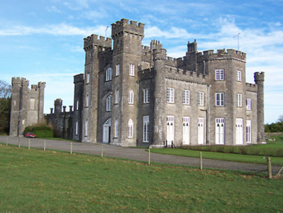
| Knockdrin Castle | A Gothic Revival castle built about 1815; it is not recorded by Leet. Located east of Lough Owel and north of Lough Drin, this castle was built by Sir Richard Levinge (1785-1848) 6th Bt to replace High Park, the Levinges’ old family home and was designed, most probably, by James Shiel. It was valued at £100 in 1906. The Castle remained the home of the Levinge family until the mid-20th century when it was sold. It is now the home of the Prondzyunski family. |
|
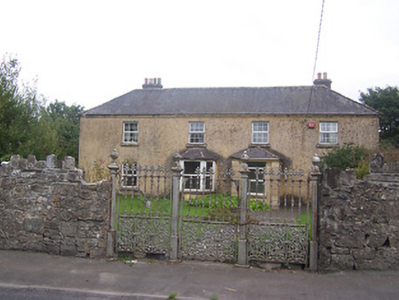
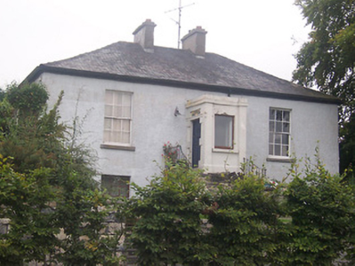
| Ballinderry Cottage | Ballinderry cottage, named on both the first six inch and 25 inch maps, Ballinderry was originally a home of William Judge of Mosstown (O’Brien). Located on the southern outskirts of Mullingar, at the time of Griffith’s Valuation (publ. 1854) Godfrey Fetherstonhaugh held the building valued at £11 from Anne ‘Cowper’ or Cooper. Home of the Bayley family at the beginning of the 20th century. O’Brien writes that a hospital now stands on the site. | |
| Ballyglass | Ballyglass, a four-bay two-storey house, built about 1820, is named on both the first six inch and 25 inch OS maps and located just north east of St Finian’s College near Mullingar. In 1814 it was the home of John McLaughlin. At the time of Griffith’s Valuation (publ. 1854) James William McLoughlin resided, holding the house valued at £16.10 in fee. This house is still extant. |
|
| Clonard House | Bellview, now known as Clonard House, is a two-bay two-storey over basement house, built about 1800, located in the town of Mullingar, home of the Walsh family. Robert Walsh was resident in 1814 and Thomas Walsh in 1837. He was still resident at the time of Griffith’s Valuation (publ. 1854), when the house was valued at £40 and held in fee. In 1876 Thomas Walsh of Bellvue owned 528 acres. In the mid-20th century this house was the residence of the Catholic Bishop of Meath. Since then it has been a tourism headquarters and an entertainment venue (O’Brien) and was for sale in 2022. |
|
| Culleen House | Culleen House is marked on the first edition OS map and had greatly expanded by the time of 25 inch, only the outbuildings remain now. O’Brien describes it as long, low seven-bay, two storey early Victorian house, purchased by Mr Mc Loughlin, a Dublin merchant, from Sir John de Blaquiere of Portloman. A Thomas McEvoy occupied Culleen in 1814. It was later sold to Godfrey Levinge, a grandson of the 4th Baronet, who was resident at the time of Griffith’s Valuation (publ. 1854), holding the house, valued at £30 in fee. Home of Thomas M Reddy and family at the time of the 1901 and 1911 censuses. This house is no longer extant. | |
| Levington Park | Levington Park is located close to the southern shore of Lough Owel. The seat of a branch of the Levinge family from the mid-18th century, it is a nine-bay two-storey country house with two-storey returns to the rear at either end (north and south), built about 1748 by Sir Richard Levinge 4th Baronet and altered in the early 19th century (boi). In 1814 Lady Levinge was resident. It was inherited by the 4th Baron’s second son Richard Hugh Levinge who was the owner in 1837. Valued at £27 at the time of Griffith’s Valuation (publ. 1854), occupied and held by Charles William Levinge in fee. Members of the Levinge family were still resident in 1901 but Hugo Fitzpatrick and his wife Gertrude were living here in 1911. O’Brien writes that Levington Park was later the residence of Edmund Dease, formerly of Turbotstown House. His son Maurice was the recipient of the first posthumously awarded Victoria Cross of World War I. The house had other owners until purchased by the author J P Donleavy in 1972. He died in 2017. |
|
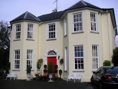
| Annebrook | Annbrook or Annebrook in the town of Mullingar was originally a three-bay two-storey over basement house, built about 1810. It was the home of Dr Robert Barlow in 1837 and at the time of Griffith’s Valuation (publ. 1854), when it was valued at £38 and held from the Earl of Granard. Still a doctor’s residence in 1911 when Dr Joseph Dillon Kelly and his wife lived at Annebrook. Now functions as a hotel, the Annebrook House Hotel. See https://www.annebrook.ie/ |
|
| Monte Video/Prospect | This house was named Monte Video on the first edition OS map and as Prospect on the 25 inch map. A doctor’s residence at the time of Griffith’s Valuation (publ. 1854) when Dr Ferguson was in occupation. Valued at £13 it was held from Anne Cowper or Cooper. It was originally located on the outskirts of Mullingar but is now surrounded by a housing estate |
|
| Springfield (Mullingar) | Springfield, on the outskirts of Mullingar, is named on both the first six inch and 25 inch maps. At the time of Griffith’s Valuation (publ. 1854) it was occupied by Thomas Tuite, held from Charlotte Tighe and valued at £20. Now demolished and replaced by Assumption Villas. |