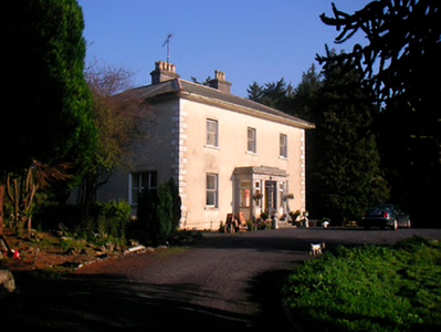
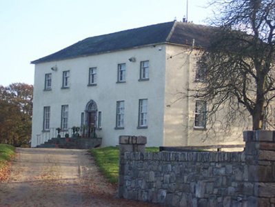
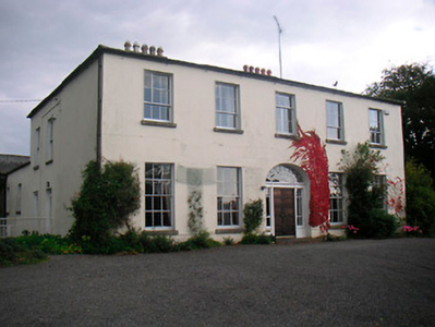
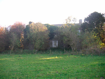
Riverstown House
Houses within 5km of this house
Displaying 13 houses.
Houses within 5km of Riverstown House
Displaying 13 houses.
| House name | Description | |
|---|---|---|
| Annaskinnan | Annaskinnan, located just south of the Grand Canal and west of Hyde Park, this house had laid out gardens marked on the first edition OS map. It was part of the estates belonging to the Crown in the early 19th century. At the time of Griffith’s Valuation (publ. 1854) the house was valued at £13, occupied by William Garty and held from Alexander Montgomery. Members of the Garty family were still resident in 1901. Complex of buildings now located on the site. | |
| Corbetstown | Corbetstown house, a D’Arcy home, is named on the first edition OS map. It is a three-bay two-storey over basement house, built about 1820. It must have replaced an earlier house as a D’Arcy is recorded at Corbetstown in the late 1770s. Francis D’Arcy was resident in 1814 and John D’Arcy in 1837. By the time of Griffith’s Valuation (publ. 1854) Joseph Purser was resident holding the house valued at £32 from the Earl of Longford. Occupied by Elizabeth and Frances Reynell in 1911, this house remains extant. |
|
| Curristown | Curristown House was a property in the ownership of the Purdon Family from about 1760. The house, a two-storey, three-bay late 18th century building, was the home of George Purdon in 1814 and 1837. Valued at £21 it was unoccupied at the time of Griffith’s Valuation (publ. 1854). Augustus C Purdon was the immediate lessor. Occupied by Algernon Briscoe and family in 1901, the house remained a Briscoe home until the mid-20th century. It was demolished in the late 20th century. |
|
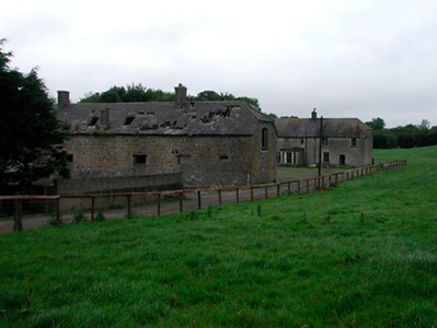
| Derrymore | Derrymore House is described by O’Brien as a two-storey, five-bay house mid-18th century building. It is named on both the earliest OS 6 inch and 25 inch maps. In 1814 it was the home of Captain Daly and in 1837 Lewis describes it as the property of T J Fetherston Haugh of Bracklyn Castle. Still in Fetherstonhaugh possession at the time of Griffith’s Valuation (publ. 1854), it was occupied by Luke Nolan and valued at £15.10. The Nolan family were still resident at the beginning of the 20th century. The house is now a ruin. | |
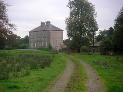
| Griffinstown | Griffinstown House, is a three-bay two-storey over a basement neoclassical house, built about 1820, with projecting Greek Ionic entrance porch (boi). It is located to the west of Kinnegad and was built for the Fetherstonhaugh family. O’Brien writes that Andrew Ennis bough Griffinstown about 1800 from the Smyths. There must have been an earlier house as the Taylor and Skinner maps of the 1770s and Leet in 1814 both record Smyths at Griffinstown. Andrew Ennis leased it to the Fetherstonhaughs and family members were resident in 1837 and at the time of Griffith’s Valuation (publ. 1854) when the house was valued at £48 and held from John Ennis. William Napier Magill was in possession at the time of the censuses of 1901 and 1911. |
|
| Huntingdon | Huntingdon, a five-bay two-storey over basement country house, built about 1770 by the Purdon family, it remained a Purdon home for all of the 19th century. Robert Purdon was resident in 1814 and 1837. Augustus Cooke Purdon held the house from Robert Purdon at the time of Griffith’s Valuation (publ. 1854), when it was valued at £20. Purdon family members were still resident in the early decades of the 20th century and the house remains extant. |
|
| Hydepark | Hyde Park, located north of Kinnegad, is a five-bay two-storey over basement country house, built about 1775 by James D’Arcy. This family were related to the D’Arcys of Corbetstown. John D’Arcy, son of James, was resident in 1814 and 1837. George D’Arcy, son of John, held the property in fee at the time of Griffith’s Valuation (publ. 1854) when the house was valued at £23. In 1906 George N Darcy is recorded as the occupant holding the property with 425 acres of untenanted land. Two D’Arcy sisters were living in Hyde Park in 1911. |
|
| Joristown | Joristown House, set in a large demesne, with a deer park to the west, as recorded on the first edition OS map, this was a Purdon home from the early 19th century as Peter Purdon was resident in 1814 and 1837. At the time of Griffith’s Valuation (publ. 1854) the house was unoccupied, valued at £16 and held from Augustus C Purdon. Shepherd Hugh Lambe was living in a house in Joristown with two of his cousins, held from General Purdon in 1901 and John Purdon in 1911. This house is now demolished. |
|
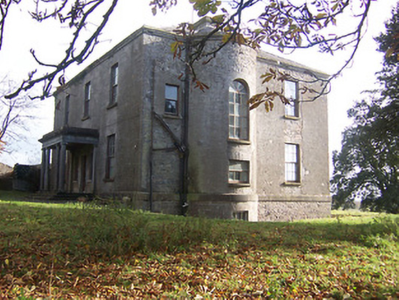
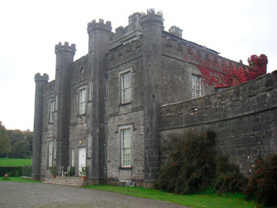
| Lisnabin Castle | Lisnabin House, located a short distance south east of Huntingdon, this three-bay two-storey castellated country house was built about 1824 by Edward Purdon to replace an earlier house that burnt down and which is referred to on the Taylor and Skinner maps of the late 1770s and by Leet in 1814 as the home of Edward Purdon. Described as 'a handsome castellated mansion recently erected', by Lewis, it was valued at £40 at the time of Griffith’s Valuation (publ. 1854) and was the residence of the same Edward Purdon who held it in fee. His son George Nugent Purdon of Lisnabin owned over 1,000 acres in the 1870s and it remained a Purdon home until the early 21st century when it was sold. |
|
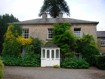
| Riggs Villa/Greenhills | Located a short distance north west of Killucan, this building is named Riggs Villa on the first edition OS map and Greenhills on the 25 inch map. It is a three-bay two-storey house, built about 1830, with two-bay two-storey return to the northeast (boi). Riggville Cottage was the home of Edward Riggs in 1814 and of Anthony Fawcett at the time of Griffith’s Valuation (publ. 1854) when it was valued at £11.10 and held from the Earl of Longford. Two Fawcett sisters were living in Killucan at the time of the 1911 census. This house is extant. |
|
| Lowtown House | Lowtown House described by O’Brien as a late 17th century, two-storey, nine-bay house over a basement built by Anthony Dopping, Bishop of Meath. Generations of Doppings lived here including four successive Anthonys. The house is referenced in Taylor and Skinner maps of the 1770s. In 1814 Samuel Dopping resided and in 1837 his son William lived here. In 1843 William married Jane daughter of the Rev Cecil Crampton and they emigrated to Australia, as did his older brother Anthony John some years later. William Dopping and his mother Anne of Lowtown appear to have been having financial difficulties in 1842 as two judgements against them for a debt of £1,840 was assigned to Philip Crampton, Lowtown, Co Westmeath MD and George Ribton Crampton, Upper Mount St, Dublin, see Dopping-Hepenstal Papers in NLI Ms. 35,871 (7). Anne Dopping, widow of Samuel, was living in the house at the time of Griffith’s Valuation (publ. 1854). It was valued at £28 and she held it in fee. Occupied by Eleanor Mary Crampton at the beginning of the 20th century and then by the Glennon family. Sold to the Land Commission in the 1950s the house was subsequently demolished and is now a green field site. | |
| Wardenstown | Wardenstown is a five-bay two-storey early 18th century country house, built c.1810 possibly incorporating the fabric of an earlier house. The house is believed to have been three-storey high when built but was later reduced in height following a fire (boi). The Berry family lived at Wardenstown in the early 18th century. The Wardenstown Papers record that the estate was later acquired by the Vandeleur family from Kilrush, Co Clare through a connection with the Knight of Kerry (PRONI D3549/F). It is probable that the Vandeleurs built the present house. In 1814 George Webb lived at Wardenstown and in 1837 T M Webb. At the time of Griffith’s Valuation (publ. 1854) Capt Crofton Thomas Vandeleur occupied the house valued at £20 and held from the Knight of Kerry and other Fitzgerald family members. Capt Crofton T. Vandeleur, lived here in the 1870s and it was still the home of members of the Vandeleur family in the early years of the 20th century. In more recent times the home of the Potterton family. |
|
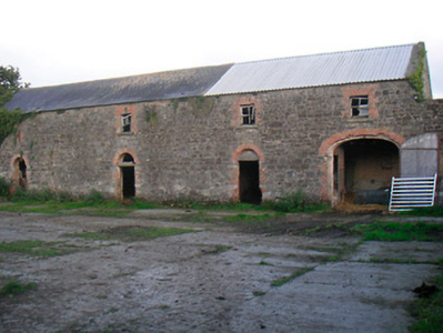
| Grange Beg House | Grange Beg House, located just north west of Shay Murtagh Pre Cast Ltd is named on both the first edition six inch OS and 25 inch maps. It was a five-bay two-storey over basement house, built about 1730 (boi). D’Arcy of Grangebeg is recorded on the Taylor and Skinner maps of the late 1770s. The D’Arcys seem to have gained possession through marriage with a Judge heiress. The property is referred to as an ‘excellent dwelling-house and extensive farm-yard and offices, all slated’ in a D’Arcy sale rental of 7 May 1850. At the time of Griffith’s Valuation (publ. 1854) Thomas Gibson was resident, holding the house valued at £17 from John Wilson. This house was still the home of members of the Gibson family at the beginning of the 20th century but is now derelict. |
|