Corbetstown
Houses within 5km of this house
Displaying 18 houses.
Houses within 5km of Corbetstown
Displaying 18 houses.
| House name | Description | |
|---|---|---|
| Curristown | Curristown House was a property in the ownership of the Purdon Family from about 1760. The house, a two-storey, three-bay late 18th century building, was the home of George Purdon in 1814 and 1837. Valued at £21 it was unoccupied at the time of Griffith’s Valuation (publ. 1854). Augustus C Purdon was the immediate lessor. Occupied by Algernon Briscoe and family in 1901, the house remained a Briscoe home until the mid-20th century. It was demolished in the late 20th century. |
|
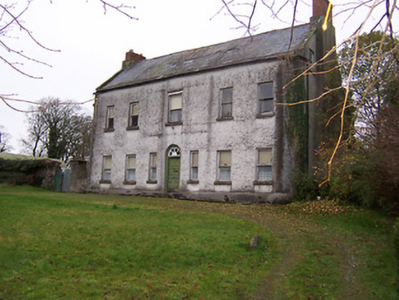
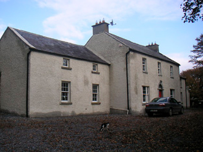
| Huntingdon | Huntingdon, a five-bay two-storey over basement country house, built about 1770 by the Purdon family, it remained a Purdon home for all of the 19th century. Robert Purdon was resident in 1814 and 1837. Augustus Cooke Purdon held the house from Robert Purdon at the time of Griffith’s Valuation (publ. 1854), when it was valued at £20. Purdon family members were still resident in the early decades of the 20th century and the house remains extant. |
|
| Joristown | Joristown House, set in a large demesne, with a deer park to the west, as recorded on the first edition OS map, this was a Purdon home from the early 19th century as Peter Purdon was resident in 1814 and 1837. At the time of Griffith’s Valuation (publ. 1854) the house was unoccupied, valued at £16 and held from Augustus C Purdon. Shepherd Hugh Lambe was living in a house in Joristown with two of his cousins, held from General Purdon in 1901 and John Purdon in 1911. This house is now demolished. |
|
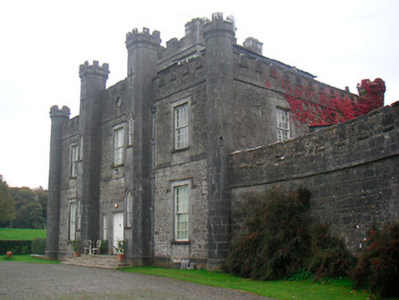
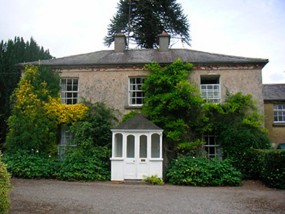
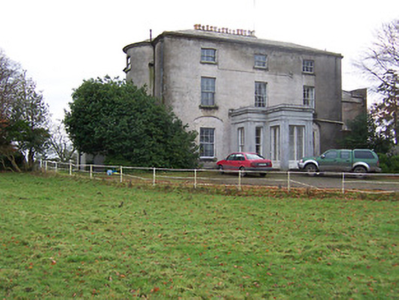
| Lisnabin Castle | Lisnabin House, located a short distance south east of Huntingdon, this three-bay two-storey castellated country house was built about 1824 by Edward Purdon to replace an earlier house that burnt down and which is referred to on the Taylor and Skinner maps of the late 1770s and by Leet in 1814 as the home of Edward Purdon. Described as 'a handsome castellated mansion recently erected', by Lewis, it was valued at £40 at the time of Griffith’s Valuation (publ. 1854) and was the residence of the same Edward Purdon who held it in fee. His son George Nugent Purdon of Lisnabin owned over 1,000 acres in the 1870s and it remained a Purdon home until the early 21st century when it was sold. |
|
| Riggs Villa/Greenhills | Located a short distance north west of Killucan, this building is named Riggs Villa on the first edition OS map and Greenhills on the 25 inch map. It is a three-bay two-storey house, built about 1830, with two-bay two-storey return to the northeast (boi). Riggville Cottage was the home of Edward Riggs in 1814 and of Anthony Fawcett at the time of Griffith’s Valuation (publ. 1854) when it was valued at £11.10 and held from the Earl of Longford. Two Fawcett sisters were living in Killucan at the time of the 1911 census. This house is extant. |
|
| Riverstown House | Riverstown House, originally known as Rathwire House, this five-bay single-storey over basement villa, was built about 1830 and was associated with a former corn mill run by the Hannons (boi). Occupied by Benjamin Hannan, valued at £15 and held from the Earl of Longford at the time of Griffith’s Valuation (publ. 1854). Samuel Clarke, agent and his wife lived here in 1901 and William Bailey, ex RIC and land agent’s assistant and his family were resident in 1911. It was bought by a Father O'Rourke in 1935 who opened the first Camillian Juniorate in Ireland here in 1949, it now functions as St Camillus Care Centre. |
|
| Wardenstown | Wardenstown is a five-bay two-storey early 18th century country house, built c.1810 possibly incorporating the fabric of an earlier house. The house is believed to have been three-storey high when built but was later reduced in height following a fire (boi). The Berry family lived at Wardenstown in the early 18th century. The Wardenstown Papers record that the estate was later acquired by the Vandeleur family from Kilrush, Co Clare through a connection with the Knight of Kerry (PRONI D3549/F). It is probable that the Vandeleurs built the present house. In 1814 George Webb lived at Wardenstown and in 1837 T M Webb. At the time of Griffith’s Valuation (publ. 1854) Capt Crofton Thomas Vandeleur occupied the house valued at £20 and held from the Knight of Kerry and other Fitzgerald family members. Capt Crofton T. Vandeleur, lived here in the 1870s and it was still the home of members of the Vandeleur family in the early years of the 20th century. In more recent times the home of the Potterton family. |
|
| Clonlost | Clonlost house is shown amidst a large demesne on the first OS map. The Nugent family were settled at Clonlost from the 17th century. The house was a two-storey, five-bay, late 18th century building (O’Brien). In 1814 it was the home of Lt Col Nugent. Lewis records it as the ‘ancient family seat of J Nugent’. At the time of Griffith’s Valuation (publ. 1854) Captain John J Nugent held it in fee when the house was valued at £40 and he owned an estate of over 3,000 acres in the 1870s. His daughter married William Lamb Palmer of Rahan, Co Kildare and it was their son Charles Colley Palmer who inherited Clonlost. Members of the Palmer family were still resident in the early years of the 20th century. The house is now a ruin. | |
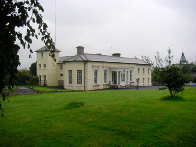
| Reynella | Reynella House is a seven-bay two-storey country house on T-shaped plan built about 1770 by Richard Reynell. In 1814 it was the seat of Richard M Reynell and in 1837 Lewis records that Reynella was 'the elegant residence of the late R. M. Reynell, Esq., now the property of a minor, situated in a fine demesne, adorned with a lake and extensive plantations'. Valued at £27 it was occupied by John Rynd at the time of Griffith’s Valuation (publ. 1854) and held from Blayney T Balfour. This house was home to the broadcaster Marian Finucane and her husband in the 1980s and was a guest house in more recent years. |
|
| Sheepstown House | Sheepstown house is named on the early 20th century 25 inch OS map. At the time of Griffith’s Valuation (publ. 1854) it was occupied by James Seery, valued at £15 and held from the representatives of Robert M Tighe. The Seery family were still resident at the beginning of the 20th century. This house is extant. | |
| Dardistown | Dardistown, described by O’Brien as a two-storey, three-bay Georgian house, a Fetherstonhaugh home in the late 18th century. In 1837 Lewis records ‘Durdistown’ as the seat of Theobald Fetherstonhaugh. By the time of Griffith’s Valuation (publ. 1854) the Metge family was in possession. John Branigan held the house valued at £12 from John C ‘Medge’ Metge. The Simons family were living in a first class house at Dardistown at the beginning of the 20th century. Buildings still occupy the site. | |
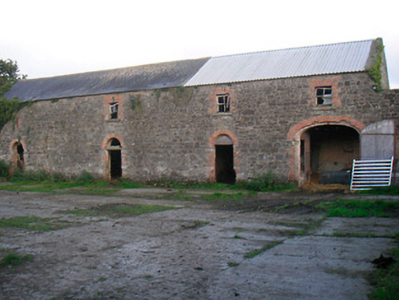
| Killagh House | Killagh House, named on the first edition OS map with a tuck mill and two corn mills closeby. This five-bay two-storey house was built about 1740 and a three-storey tower house is connected to the rear. At the time of Griffith’s Valuation (publ. 1854) it was valued at £10, occupied by Patrick Connell and held from Sir John Nugent. This building is no longer in use. https://www.antaisce.org/killagh-house-killeagh |
|
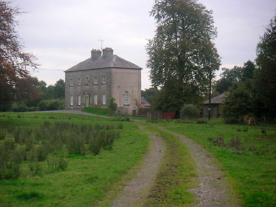
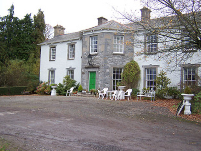
| Rockview House | Rockview House is a three-bay three-storey building over a basement. It was built in the early 19th century (but not recorded by Leet) for the Fetherstonhaugh family. In 1837 Mrs Richard Fetherstonhaugh was resident. At the time of Griffith’s Valuation (publ. 1854) her son Richard occupied the house, valued at £70 and held from Thomas J Fetherstonhaugh. The Fetherstonhaugh family continued to occupy the house well into the 20th century and it remains a private residence. |
|
| Bracklyn House | On the first edition OS map Bracklin House is set in an extensive demesne with gardens, plantation and outbuildings. It is a five-bay two-storey over basement neoclassical country house, built in the late 18th century by a branch of the Fetherstonhaugh family on land acquired from the Pakenham Family of Tullynally Castle, Castlepollard. Single storey wings were added in 1910. James Fetherstonhaugh was resident in 1814 and his son Thomas James in 1837. At the time of Griffith’s Valuation (publ. 1854) Anne Gavan was the occupant holding the house valued at £70 from Thomas James Fetherstonhaugh. At the beginning of the 20th century Captain Cecil Howard Digby Fetherstonhaugh and family lived at Bracklin. In 1906 the buildings were valued at £60 and held with 2,300 acres of untenanted land. O’Brien writes that in recent times Mr and Mrs Sean Murphy have restored the house. |
|
| Craddanstown House | A building is marked on the first edition OS map at this site which is greatly expanded and named on the 25 inch map as Craddanstown House. The originally house probably dates from the early 19th century and the building was extensively altered sometime in the mid-19th century. Valued at £10 and occupied by James Gibson at the time of Griffiths Valuation (publ. 1854), when it was held from the Earl of Longford. James Gibson and family were still resident at the beginning of the 20th century. |
|
| Craddanstown Lodge | Craddanstown Lodge is named on the first edition OS map as Craddanstown House, and on 25 inch as Craddanstown Lodge. It is a three-bay two-storey house, built about 1800, with two storey wings on each side. Craddenstown House was the home of Lockhart Ramage in 1814 and 1837 so must refer to the Lodge. Lockhart Ramage was resident at the time of Griffith’s Valuation (publ. 1854), when the house was valued at £17 and held from the Earl of Longford. The census of 1911 records Lockhart Ramage aged 82, gentleman farmer, as head of the household. O’Brien writes that the house was sold in 2013 and it was on the market again in 2017. This house was more substantial than the other Craddanstown until the other was altered about 1860. |
|
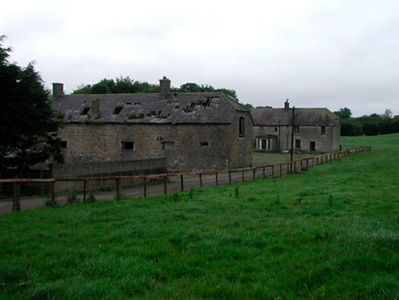
| Grange Beg House | Grange Beg House, located just north west of Shay Murtagh Pre Cast Ltd is named on both the first edition six inch OS and 25 inch maps. It was a five-bay two-storey over basement house, built about 1730 (boi). D’Arcy of Grangebeg is recorded on the Taylor and Skinner maps of the late 1770s. The D’Arcys seem to have gained possession through marriage with a Judge heiress. The property is referred to as an ‘excellent dwelling-house and extensive farm-yard and offices, all slated’ in a D’Arcy sale rental of 7 May 1850. At the time of Griffith’s Valuation (publ. 1854) Thomas Gibson was resident, holding the house valued at £17 from John Wilson. This house was still the home of members of the Gibson family at the beginning of the 20th century but is now derelict. |
|
| Grange More House | Grange More House, located in a large demesne on the first edition OS map. It was a five-bay three-storey over basement house, built in 1823 by John Fetherston inherited by his nephew Edward Briscoe of Riverdale (O’Brien). There must have been an earlier house as the Taylor and Skinner maps of the late 1770s mention Grangemore of Fetherston Esq. Leet records John Fetherston of Grangemore, Killucan in 1814 and it was the seat of Edward Briscoe in 1837 when it was described as 'a handsome house in a well-planted demesne'. Valued at £60 it was occupied by Captain William Graham at the time of Griffith’s Valuation (publ. 1854) and held from the Briscoes minors. The mansion house at Grange More was in the occupation of Augusta E Magan in 1906 [she had died in 1905] who held it with 1,922 acres of untenanted land. It is now a ruin. |