Guilford House
Houses within 5km of this house
Displaying 12 houses.
Houses within 5km of Guilford House
Displaying 12 houses.
| House name | Description | |
|---|---|---|
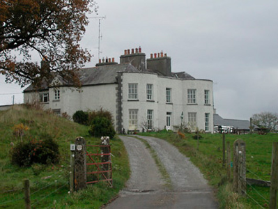
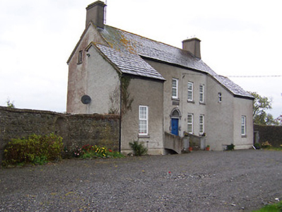
| Cornaher | Cornaher House, named on the first edition OS map, is a two-storey seven-bay country house, built in the early 19th century by the Rev John Vignoles, of Hugenot decent. He married a member of the Lowe family who previously owned the property. It was the home of the Rev. Charles Vignoles in 1814 and 1837, who was rector of the nearby Newtown Church of Ireland church. His sons Thomas and Samuel were in residence at the time of Griffith’s Valuation (publ. 1854) when the house was valued at £32. The Rev Charles Vignoles died at Cornaher in 1877. It was occupied by William George Lowe and family in 1901 and by the Davis family in 1911. Since then it has had a number of owners, been in use as an organic farm and Bed and Breakfast and was for sale in 2022. |
|
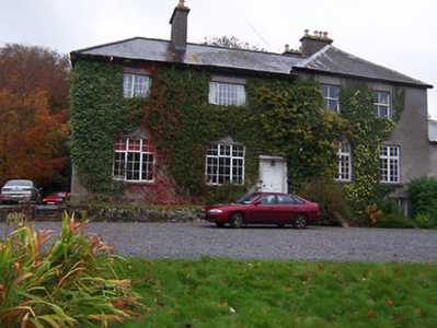
| New Forest | New Forest is a five-bay three-storey over basement country house, built in the 1770s by the Evans family and acquired by Henry Daniel before the end of the century. In 1837 New Forest was the home of a H. Daniel described by Lewis as ‘one of the most complete and gentlemanly residences in the county of Westmeath’. In 1843 Henry was succeeded by his son Robert Daniel who Griffith’s Valuation (publ. 1854) records was the occupant holding the house valued at £55 from Francis Evans. When the Evans estates in counties Mayo, Monaghan and Westmeath were for sale in the Landed Estates Court in November 1871, Newforest was described as forming 'one of the most complete and gentlemanly residences in the county of Westmeath'. (LEC rental 14 November 1871). O’Brien writes that the Daniels bequeathed the estate to the Catholic Church in the 20th century. It was sold in 1948 to Lt-General Sir Charles Gairdner, who was later appointed Governor of Western Australia (1951–1963) and then Governor of Tasmania (1963-68). Its extensive mature landscaped grounds are now in use as a golf course and the house is a hotel see https://newforest.ie/ | |
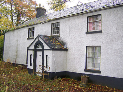
| Knock House | Knock house is marked on the first edition OS map and named on 25 inch. It is a three-bay two-storey house with a return, built about 1815 and still extant. At the time of Griffith’s Valuation (publ. 1854) the house was occupied by John Robinson who held it from Sir William Leeson. It was valued at £10. |
|
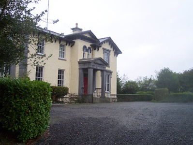
| Ballynagore House | This house was not built at the time of the first edition OS map (1838). It is a four-bay two-storey over basement house built in an Italianate style about 1852 for John Perry to designs by John Skipton Mulvany (1813-1870). The Perry Family were a prominent milling family in Ballynagore, having bought out the milling interests of the Mulock family in 1838, and owned the large mill to the southwest of the village and other extensive buildings in the locality at the time of Griffith’s Valuation (publ. 1854). The Perrys held their milling interests from the Very Rev Charles Vignoles. At this time the house was valued at £35 and was the residence of John Marshall. Now functions as a Bed and Breakfast. |
|
| Far View House | Far View House, an early 19th century two-bay, three storey house, originally a home of the North family. David North who married Catherine Pim was resident in 1837 and at the time of Griffith’s Valuation (publ. 1854), when the house was valued at £15 and held from Catherine Reynolds. The house was occupied by the Gavin family in the early 20th century. |
|
| West House | West House is a five-bay two-storey over a basement country, built about 1760, having projecting single-bay wings. O’Brien states that it was built by a family named West and that it was sold to Patrick Gavin in 1822 and that this family still live there. In 1814 it was the residence of Robert Johnston. At the time of Griffith’s Valuation (publ. 1854) it was valued at £9.10, occupied by Patrick Gavin and held from Catherine Reynolds. |
|
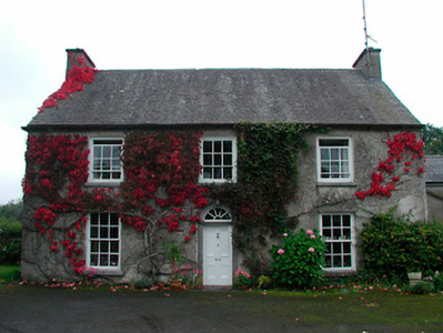
| Calverstown | Named on the first edition OS map, Calverstown House is a three-bay two-storey over basement house, built about 1800. Originally a Rochfort home it was occupied by Charles Rochfort in 1814. Calverstown House was the home of J. Hornidge in 1837. At the time of Griffith’s Valuation (publ. 1854) it was valued at £10, occupied by George Hornidge and held from Pilkington. Hornidge family members continued to live here until the mid-20th century. |
|
| Dalystown | Dalystown, marked on the first edition OS map and named on the 25 inch map, a three-bay two-storey house, built about 1810. It was the home of Charles Pilkington in 1837 and at the time of Griffith’s Valuation (publ. 1854). Valued at £11 the house was held from James W Berry with 189 acres. |
|
| Dalystown House | Dalystown House, marked on the first edition OS map and named on the 25 inch map. According to the Griffith’s Valuation map this was the house valued at £9 occupied by Samuel Cantrell who held it and 218 acres from James M Berry. This house was demolished. | |
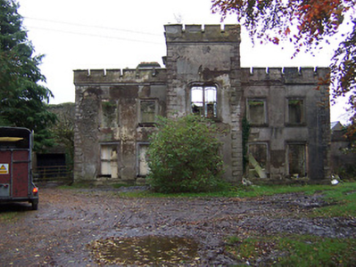
| Newcastle | A five-bay two-storey castellated country house, built or rebuilt in the mid-19th century by the Coffey family who bought the property from the Norths in the 1780s. It is now derelict. The National Built Heritage Service states that the remains of an earlier house built by the North family, c.1740, and a tower house built c.1640 can be seen to the rear (west). The Taylor and Skinner maps record Newcastle as the property of the Norths. In 1814 and 1837 Newcastle was the home of Christopher Coffey. At the time of Griffith’s Valuation (publ. 1854) Richard Coffey was resident, when the house valued at £30 was held from Charles B Marley. The house would appear to have been unoccupied at the beginning of the 20th century. |
|
| Templeoran House | Templeoran House, named on the first edition OS map, this was a two-storey, five-bay late 18th century house which O’Brien states has been an ivy covered ruin for many years. In 1837 Mrs Johnson was resident and at the time of Griffith’s Valuation (publ. 1854) the house was the home of Edward Fetherstonhaugh, valued at £8.10 and held from George A Boyd. | |
| Tore | This house is named Toor on the first edition OS map and Torr on the 25 inch map. Located a short distance south east of Tyrrellspass, it was a two-storey, five-bay 18th century house, built by the Pilkington family and marked on the Taylor and Skinner map of the late 1770s. Henry Pilkington of Tore was a subscriber to Lewis’ Topographical Dictionary. The house was occupied by him at the time of Griffith’s Valuation (publ. 1854). Valued at £25 it was held from Charles B Marlay. Henry Mulock Pilkington of Tore owned 1,683 acres in county Westmeath in the 1870s. The house was burnt in the early 1920s and is now a ruin. |