Dalystown
Houses within 5km of this house
Displaying 13 houses.
Houses within 5km of Dalystown
Displaying 13 houses.
| House name | Description | |
|---|---|---|
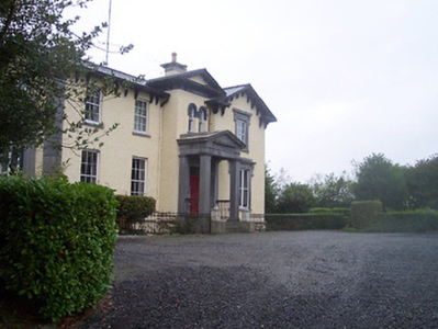
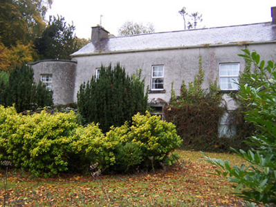
| Lilliput | Andrew Savage Nugent was occupying Lilliput in 1814. Lilliput and Dysart House, also owned by Andrew Savage Nugent, were recorded as uninhabited and in ruins by Lewis in 1837. Griffith’s Valuation records Lilliput as an unoccupied house in the townland of Nure or Lilliput, parish of Dysart, valued at £7.10. The immediate lessor was George A Boyd. Lilliput is also mentioned in the 1906 list when valued at £12.5 and occupied by the representative of Captain R H Boyd Rochfort. O’Brien describes the house as a late 18th century two-storey three-bay building, situated on the shore of Lough Ennell, ‘recently restored’. | |
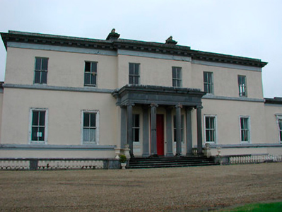
| Middleton Park | Middleton House is marked on the first edition OS map (1838), with extensive gardens to the south east. The present house is a six-bay two-storey over basement country house, built c.1850, in an Italianate style to designs by George Papworth (1781-1855) for George Augustus Boyd. He was resident at the time of Griffith’s Valuation (publ. 1854) when the building was valued at £100. It replaced an earlier smaller-scale house on the site, the property of James M Berry, who was resident in 1814 while W Hudson was the occupant in 1837 holding it from Berry. The present house remained in the Boyd-Rochfort family until 1958 and has had a number of owners since then, one of whom Barney Curly sold it through conducting a raffle. It has since been a hotel and was on the market again in 2023. |
|
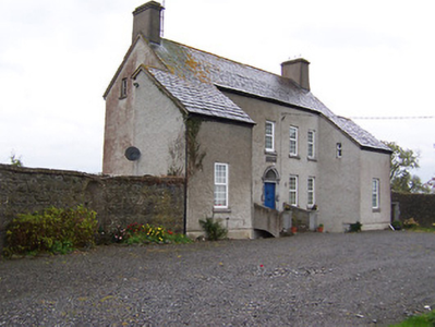
| Knock House | Knock house is marked on the first edition OS map and named on 25 inch. It is a three-bay two-storey house with a return, built about 1815 and still extant. At the time of Griffith’s Valuation (publ. 1854) the house was occupied by John Robinson who held it from Sir William Leeson. It was valued at £10. |
|
| Ballynagore House | This house was not built at the time of the first edition OS map (1838). It is a four-bay two-storey over basement house built in an Italianate style about 1852 for John Perry to designs by John Skipton Mulvany (1813-1870). The Perry Family were a prominent milling family in Ballynagore, having bought out the milling interests of the Mulock family in 1838, and owned the large mill to the southwest of the village and other extensive buildings in the locality at the time of Griffith’s Valuation (publ. 1854). The Perrys held their milling interests from the Very Rev Charles Vignoles. At this time the house was valued at £35 and was the residence of John Marshall. Now functions as a Bed and Breakfast. |
|
| Carrick | Carrick House located near the eastern shore of Lough Ennell, named on the first edition OS map, this is an eight-bay two-storey house, built c.1740. It is recorded on the Taylor and Skinner maps of the late 1770s and was the home of the Fetherstonhaugh family. It was the residence of William Fetherstonhaugh (died 1851) in 1837 and held by his son, another William, in fee at the time of Griffith’s Valuation (publ. 1854) when the house was valued at £29. He married Alicia daughter of Thomas Berry and they had a son Francis Berry Fetherstonhaugh who married Elizabeth Hornidge of Calverstown. Their descendants were still living at Carrick in the 1920s. |
|
| West House | West House is a five-bay two-storey over a basement country, built about 1760, having projecting single-bay wings. O’Brien states that it was built by a family named West and that it was sold to Patrick Gavin in 1822 and that this family still live there. In 1814 it was the residence of Robert Johnston. At the time of Griffith’s Valuation (publ. 1854) it was valued at £9.10, occupied by Patrick Gavin and held from Catherine Reynolds. |
|
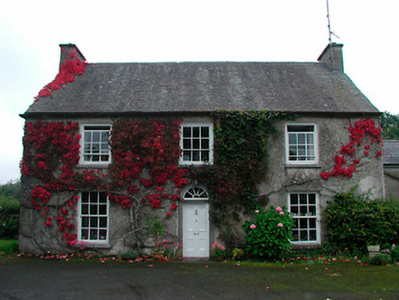
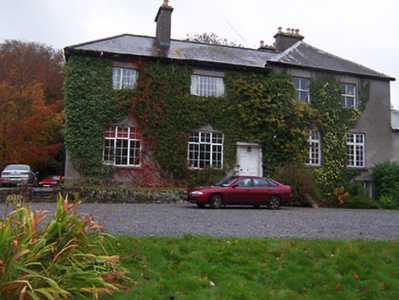
| Calverstown | Named on the first edition OS map, Calverstown House is a three-bay two-storey over basement house, built about 1800. Originally a Rochfort home it was occupied by Charles Rochfort in 1814. Calverstown House was the home of J. Hornidge in 1837. At the time of Griffith’s Valuation (publ. 1854) it was valued at £10, occupied by George Hornidge and held from Pilkington. Hornidge family members continued to live here until the mid-20th century. |
|
| Dalystown House | Dalystown House, marked on the first edition OS map and named on the 25 inch map. According to the Griffith’s Valuation map this was the house valued at £9 occupied by Samuel Cantrell who held it and 218 acres from James M Berry. This house was demolished. | |
| Guilford House | This land was originally the property of the North family who were connected to the Earls of Guilford. A five-bay two-storey house over a raised basement, built in the late 18th century, possibly by the Reynolds family, but was leased to the Usher family by the end of the century. Occupied by Christopher Coffie/Coffey junior in 1814 and by F. Usher in 1837. At the time of Griffith’s Valuation (publ. 1854) Christopher Swift held the house valued at £12 from Francis Usher. O’Brien writes that the Reynolds family still own Guilford House. |
|
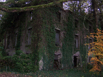
| Newcastle | A five-bay two-storey castellated country house, built or rebuilt in the mid-19th century by the Coffey family who bought the property from the Norths in the 1780s. It is now derelict. The National Built Heritage Service states that the remains of an earlier house built by the North family, c.1740, and a tower house built c.1640 can be seen to the rear (west). The Taylor and Skinner maps record Newcastle as the property of the Norths. In 1814 and 1837 Newcastle was the home of Christopher Coffey. At the time of Griffith’s Valuation (publ. 1854) Richard Coffey was resident, when the house valued at £30 was held from Charles B Marley. The house would appear to have been unoccupied at the beginning of the 20th century. |
|
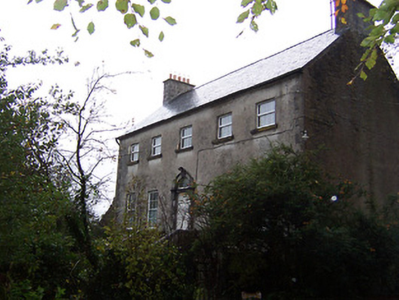
| Templeoran House | Templeoran House, named on the first edition OS map, this was a two-storey, five-bay late 18th century house which O’Brien states has been an ivy covered ruin for many years. In 1837 Mrs Johnson was resident and at the time of Griffith’s Valuation (publ. 1854) the house was the home of Edward Fetherstonhaugh, valued at £8.10 and held from George A Boyd. | |
| Kilbride | Kilbride House is a three-bay two-storey house, built about 1810 to the north of Kilbride Castle. The Norths were in possession of Kilbride in the 18th century and Mrs North was resident in Kilbride House in 1814. The list of subscribers to Lewis’ Topographical Dictionary in 1837 includes A J Pilkington of Kilbride Castle. He was married to Mary daughter of Roger North. At the time of Griffith’s Valuation (publ. 1854) the house valued at £9 was occupied by Abraham Pilkington who held it from the representatives of R W Cooper. James King and family were resident at Kilbride in 1901 and 1911. |
|
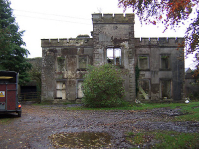
| Dunboden Park | Dunboden Park is named on the first edition OS map with pleasure grounds to the east. A late 18th century neoclassical country house built by the Rochforts, one of whom was murdered on the steps of the house in 1797. The house was reputedly remodelled by Sandham Symes (1807-1898), about 1860 for the Cooper Family of Markee Castle, county Sligo (boi). The Coopers purchased the estate after the death of Robert Rochfort in 1797 and remained in possession until the early 20th century. At the time of Griffith’s Valuation (publ. 1854) the house, offices, gatelodge and lodge were valued at £73. Anne Cooper was resident holding the property from Abraham Pilkington. By 1906 the valuation had increased to £93 and Colonel Edward Cooper was the occupant. The house was burnt in 1923. A mausoleum to Joshua Harry Cooper who died 1819 is located to the south of the ruins of the house. |
|