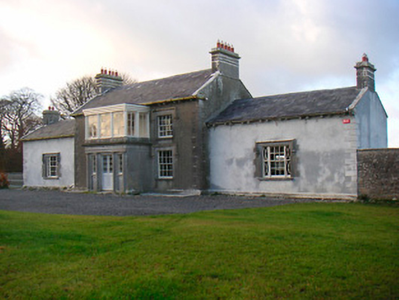
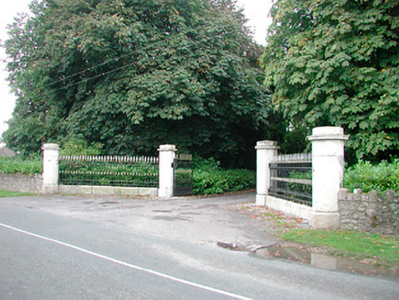
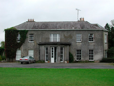
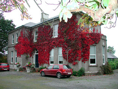
Jamestown House
Houses within 5km of this house
Displaying 9 houses.
Houses within 5km of Jamestown House
Displaying 9 houses.
| House name | Description | |
|---|---|---|
| Knocknacreeve House | A building is marked at this site on the first edition OS map and a building of a different shape named Knocknacreeve House on 25 inch map. Richard Ham occupied this house valued at £14 which he held from Robert Smith, at the time of Griffith’s Valuation (publ. 1854). It is now the centre of a farm complex of buildings. | |
| Redmondstown | Redmondstown is named on the first edition OS map and 25 inch map. The National Built Heritage Service records that the main entrance was erected about 1800. In 1814 John Tisdall is recorded as resident. At the time of Griffith’s Valuation (publ. 1854) it was occupied by Frederick Hart who held the house valued at £10 from Jerome Tisdall. The house is now demolished. | |
| Togherstown | Togherstown House, named The Lodge on the first edition OS map with a small demesne. This is a three-bay two-storey over basement house, built before 1837 possibly incorporating the remains of an earlier house c.1700 built by Thomas Magan, High Sheriff of Co Westmeath. By 1837 Togherstown House was in the occupation of William Thomas Dillon (d. 1870). It was valued at £22 at the time of Griffith’s Valuation (publ. 1854), William T Dillon holding it from William H Magan MP. William Thomas Dillon was the son of Thomas Dillon of Lung, county Mayo and was married to Teresa daughter of Edmund Count Nugent of Ballinacor, county Westmeath. Margaret Treddin, widow and caretaker, and her family were resident in 1901 and 1911 holding the property from Julia Dillon of Dublin. The house was restored in the 21st century. |
|
| Barrettstown | Barrettstown House was not built at the time of the first edition OS map (c. 1837). It is located just south of the railway line. At the time of Griffith’s Valuation (publ. 1854) it was valued at £22 and occupied by Thomas Murray who held the property from John Savage Nugent. Still occupied by the Murray family in 1911, this house is extant. |
|
| Dysart House | Dysart House was in ruins at the time the first edition OS map was compiled in the 1830s The Nugent family were resident here in the 18th century. Nugent of Desert is recorded on the Taylor and Skinner maps of the late 1770s. Lavallin Nugent born in 1722 died unmarried and the property was inherited by his brother John. When he died in 1812 it passed to his nephew Andrew Savage of Portaferry, Co Down who took the additional name of Nugent. Andrew Savage Nugent never lived at Dysart and it became a ruin. | |
| Bellmount House | Bellmount House, Curristown, is named on both the first six inch and 25 inch OS maps. It is a five-bay two-storey house, built about 1820. Although built on part of the Lyons of Ladestown estate, Bellmount House was in the possession of the Reilly family for most of the 19th century. The two families were related. In 1814 John Lyons is recorded as the occupier and in 1837 W Reilly. At the time of Griffith’s Valuation (publ. 1854) William Haig was resident holding the house valued at £36 from the representatives of Anthony A Reilly. Home of Arthur and Alice Trevor Booth in 1911. In the mid-20th century O’Brien records that Bellmount was in the ownership of the Gainsford-St Lawrence family of Howth Castle, Dublin. |
|
| Lakefield/Keoltown House | This house is named Lakefield on the first edition OS map and Keoltown House on the 25 inch map. Near the northern shore of Lough Ennell this five-bay two-storey over basement house was built about 1800 and substantially altered about 1885, with the construction of a new entrance block to the front of the existing house, (boi). This house was a L’Estrange home in the early 19th century. John L’Estrange was resident in 1814. By the time of Griffith’s Valuation (publ. 1854) John Swift was the occupier holding the house valued at £14 from John Charles Lyons. The L’Estrange and Swift families were related. John Swift of Keoltown owned 454 acres in the 1870s. The Swifts were still living at Keoltown at the time of the 1901 and 1911 censuses. The buildings were valued at £29.5 in 1906 and held with 457 acres of untenanted land. This house was for sale in 2020. |
|
| Strokestown (Mullingar) | Stokestown, located beside the railway line and marked but not named on either the first six inch of 25 inch OS maps. At the time of Griffith’s Valuation (publ. 1854) the house was valued at £14, occupied by John McKeown and held from Lord Vaux. In September 1862 John McKeon was selling Stokestown and 145 acres in the Landed Estates Court, held under a lease from Lord Vaux, dated 6 August 1853. William Mullen, shepherd, and his family were living in a first class house in Stokestown in 1901, held from W H Middleton. A building remains on this site. | |
| Greenpark House | Greenpark House, previously known as Tuitestown, located south west of Mullingar, now a green field site. Members of the Hudson/Hodson family lived here as recorded on the Taylor and Skinner maps of the late 1770s when the property was known as Tuitestown and in Leet’s directory of 1814 when Hartley Hudson was resident at Greenpark. By the time of Griffith’s Valuation (publ. 1854) Elizabeth Connolly was occupying the house, valued at £28 and held from Sir George Hodson. |
|