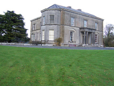
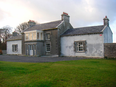
Hallstown House
Houses within 5km of this house
Displaying 17 houses.
Houses within 5km of Hallstown House
Displaying 17 houses.
| House name | Description | |
|---|---|---|
| Glencara House | This building is named Corr House on the first edition OS map but was later known as Glencarry or Glencara House. It was built for the Kelly family in the 1820s with later additions, c.1840. Glencarry was the residence of a J H Kelly in 1837 and of Robert Hume Kelly at the time of Griffith’s Valuation (publ. 1854) when the house was valued at £40 and held in fee. It remained in the possession of the Kelly family until Colonel Arthur Bellingham bought the house in the late 1930s. |
|
| Dalystown | Dalystown is marked on the first edition OS map and named on the 25 inch map. It is a detached three-bay two-storey house, built in the early 19th century. Valued at £12 at the time of Griffith’s Valuation (publ. 1854), occupied by Lewis Meares and held from John Rotton. |
|
| Washford House | Washford House is a five-bay single-storey house, built c.1845, with a shallow projecting porch to the centre. Valued at £20 and held by Captain H Boyd Gamble in fee at the time of Griffith’s Valuation (publ. 1854). |
|
| Darlington Lodge | Darlington Lodge, named on the first edition OS map, occupied by A McDonnell in 1837 and by John Malone and held from Captain H Boyd Gamble at the time of Griffith’s Valuation (publ. 1854) when valued at £18. O’Brien writes that it was possibly built as a dower house for Hallstown/Halston. The home of the Kenny family in recent times. | |
| Toberville House | Toberville House is named on the first edition OS map. At the time of Griffith’s Valuation (publ. 1854) it was occupied by Thomas Murtagh, valued at £12 and held from Captain H Boyd Gamble. A building is still located at this site. | |
| Charleville/Lunestown House | This building was named Charleville House on the first edition OS map and Lunestown House on the 25 inch map. A late 18th century five-bay two-storey over basement country house, built 1790 (keystone) and altered c. 1830 and c.1890. Charles Kelly built the house and its first name was derived from his Christian name. He was the occupant in 1814. In 1837 Lewis recorded Charleville as the seat of C Kelly and in the mid-19th century John Hubert Kelly held the house valued at £22 from William H Magan MP. Martin Charles Kelly JP and his wife Emily were resident in 1901 and 1911. |
|
| Togherstown | Togherstown House, named The Lodge on the first edition OS map with a small demesne. This is a three-bay two-storey over basement house, built before 1837 possibly incorporating the remains of an earlier house c.1700 built by Thomas Magan, High Sheriff of Co Westmeath. By 1837 Togherstown House was in the occupation of William Thomas Dillon (d. 1870). It was valued at £22 at the time of Griffith’s Valuation (publ. 1854), William T Dillon holding it from William H Magan MP. William Thomas Dillon was the son of Thomas Dillon of Lung, county Mayo and was married to Teresa daughter of Edmund Count Nugent of Ballinacor, county Westmeath. Margaret Treddin, widow and caretaker, and her family were resident in 1901 and 1911 holding the property from Julia Dillon of Dublin. The house was restored in the 21st century. |
|
| Ballinacor | Ballinacor is named on the first edition OS map. This two-storey, five-bay house was erected c 1740 and was the home of the Nugent family who were resident here from the 17th century until the mid-19th century. Referenced on the Taylor and Skinner maps of the late 1770s and occupied by Edward Nugent in 1814. In 1852 James Nugent, Count Nugent, sold the Ballinacor estate to the Halls. The sale rental describes the house as ‘large and commodious and in perfect habitable order’. At the time of Griffith’s Valuation (publ. 1854) Charles Hall held the house valued at £23 in fee. In 1906, Major George C Hall was recorded as the occupant. Bought by the Finnerty family in the early 20th century, the house is now demolished but the main entrance gates remain. |
|
| Killare House | Killare House is named on the first edition OS map, it is now a green field site as O'Brien notes it is long demolished. Valued at £12 at the time of Griffith’s Valuation (publ. 1854) it was occupied by Robert Matthews and held from Reverend Dean Pakenham. | |
| Mount Dalton | Mount Dalton, named on the first edition OS map but on the 25 inch map (c 1914) as Loughazon Hall. It is a six-bay two-storey over basement country house, built 1784, on a rectangular plan. Erected by Count Richard D'Alton (d. 1790) on his return to Ireland following a distinguished career in the Austrian Service but subsequently vacated by him when he took up the post of Governor of the Austrian Netherlands (Lewis 1837 II, 491-2). Lewis describes the house as standing 'on the banks of a fine sheet of water ... formerly the seat of the ancient family of D'Alton ... the house which is now the residence of O W C Begg was built in 1784 by Count Richard D'Alton'. Valued at £16, it was unoccupied at the time of Griffith’s Valuation (publ. 1854) and the immediate lessor was Thomas Babington. Historic connections with the D'Alton family including Count Oliver D'Alton (d. 1799); Ignatius Dillon Begg (d. 1813) and Countess Elizabeth Begg (née D'Alton) (d. 1832); Oliver William Costello Dillon Begg (d. 1848) [of] Mount Dalton Rathconrath (Lewis 1837 xi); and the Brabazon family. Mount Dalton is the home of the Brabazon Gibson family. | |
| Rathcastle | An early 19th century three-bay two-storey over a basement house, named on the first edition OS map. Rathcaslin was the residence of Thomas Banon, in 1837. By the time of Griffith’s Valuation (publ. 1854) George Murdoch occupied the house valued at £23 from John Devenish Meares. Home of William Brabazon in 1901. It was still in the possession of the Meares in 1906 and is still extant. |
|
| Mearescourt | Named on the first edition OS map, this five-bay three-storey over basement Palladian country house was built about 1760, possibly incorporating the remains of earlier buildings, including a Medieval tower house. John Meares died in 1790 leaving his estate to his nephew, William Devenish. In 1814 William Devenish Meares was resident and in 1837 it was the seat of J Devenish Meares, as it was at the time of Griffith’s Valuation (publ. 1854) when the house was valued at £35. It remained a Meares home until the 1930s. In use as a guesthouse in the early 21st century. |
|
| Oldtown | Oldtown is named on the first edition OS map and the 25 inch map. A two-storey, three-bay house built by the Banon family. Occupied by J Banon in 1837 and at the time of Griffith’s Valuation (publ. 1854) by Thomas Bannon who held the property valued at £13 from James Fallon. Oldtown was for sale in the Encumbered Estates Court in 1851. The house, described as a comfortable two-story house, fit for the residence of a gentleman, was occupied by Anne, Frances and Maria Banon, (Sale Rental 19 Dec 1851) and was bought by James Fallon, a wine and spirit merchant of Dublin. James Fallon of Oldtown is recorded among the 1876 landowners of the county. The Fallon family were still resident at the beginning of the 20th century. | |
| Ballincurra House (Rathconrath) | Benjamin Digby held this property in fee at the time of Griffiths Valuation in the early 1850s when it was valued at £23. The original Valuation Office books had valued the property at £25 in 1850, It had a similar valuation in 1906 when it was owned by William Benjamin Digby. It survived into the 20th century but is now a ruin. | |
| Moyvore | Peter Odlum was leasing this property from the Grogan estate at the time of Griffiths Valuation, when it was valued at £12. | |
| Beech Lawn (Ballymahon) | George Meares was leasing this property from the Grogan estate at the time of Griffiths Valuation, when it was valued at almost £17. A house is still extant at this site. | |
| Baltacken House | Abraham Coates was leasing this property from Nathaniel McElthwaite at the time of Griffiths Valuation when it was valued at £12. It was described as a caretaker’s house with offices. It is labelled Baltacken House on all editions of the Ordnance Survey map and is still extant and in use. |