Moyvoughly
Houses within 5km of this house
Displaying 9 houses.
Houses within 5km of Moyvoughly
Displaying 9 houses.
| House name | Description | |
|---|---|---|
| Rosemount House/Oldcourt | Rose Mount House is also known as Old Court, both names appear on the OS maps. The village nearby is known as Rosemount. Described by buildings of Ireland as a well-balanced structure originally built by the Geoghegan Family in the late eighteenth-century, probably replacing an earlier house. Leet records John Pim occupying a house named Rosemount near Moate in 1814 and Lewis records Lady Nagle as the occupant in 1837. O’Brien writes that it was inherited by the Nugent family of Ballinacor through marriage. At the time of Griffith’s Valuation it was occupied by John J Nugent who held it from the representatives of Sir Richard Nagle. It was valued at £21.10. Still extant and occupied. |
|
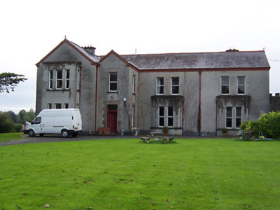
| Coolatore | This house was not built at the time of the first edition OS survey. It was constructed about 1866 and was the home of members of the Upton family. In 1906 it was valued at £56, occupied by Henry N S Upton who held it with over 400 acres of untenanted land. According to the discover Ireland website it now provides self-catering accommodation. |

|
| Grouse Lodge | Grouse Lodge is named on both the first 6 inch and 25 inch OS maps. Described as a three-bay two-storey over basement country house with attic level, built c.1810 (boi), now in use as a residential recording studio. Grouse Lodge was built by a branch of the Fetherstonhaugh Family of Ardagh, County Longford and was occupied by Theodore Fetherston in 1814 and by William Fetherstonhaugh at the time of Griffith’s Valuation. The building valued at £24 was held from Edward Fetherstonhaugh, who was the occupant in 1837. It is still a family home. |

|
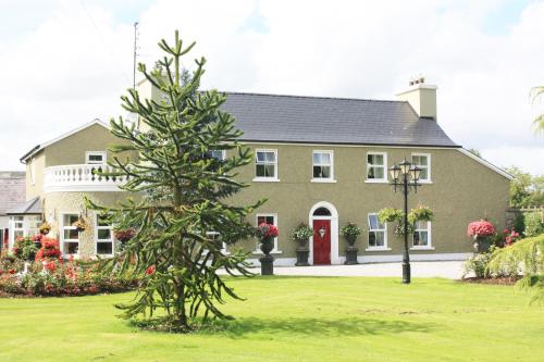
| Ballinderry | Detached four-bay two-storey country house, built about 1870, replacing an earlier house built by Sarah Kelly. The stable block appears to be 18th century. The estate was bought in 1840 by solicitor Edmond Kelly of Rookwood House, Co Roscommon, who also owned Kiltoom House, Athlone. At the time of Griffith’s Valuation (publ. 1854) Sarah Kelly was the occupant of the house valued at £19. She held it in fee. It was inherited by her nephew Robert Bailey whose descendants lived at Ballinderry until the mid-20th century when it was bought by the Land Commission. The house is extant. |
|
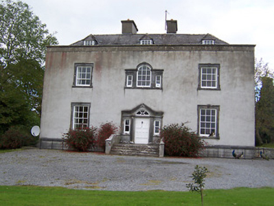
| Mount Temple House | Mount Temple House is marked on the first edition OS map, south of Holy Trinity Church and named on the 25 inch map. Leet records Richard Telford as resident at Mount Temple. At the time of Griffith’s Valuation (publ. 1854) Sarah Russell held the house and 182 acres from the Hon R T H Temple, the buildings were valued at £12. This house now provides accommodation for guests. See lodging-world.com/ei/hotels/mount-temple-house-in-moate-91944640. |
|
| Umma or Emoe House | Umma or Emoe House is named on the first edition OS map. It was a Magan home from at least the early 18th century. Thomas Magan was resident in 1814. O’Brien writes that Francis Magan was the last family member to reside at Emoe. It was recorded as his seat in 1837. He died in 1841. At the time of Griffith’s Valuation (publ. 1854) James Hill Shaw held the house valued at £15 from George A Boyd. Another building with the same name is marked on the 25 inch map to the south east of the original house and is still extant (N198 453). This second house was built in 1900 (O’Brien) by the Shaw family. James Shaw of Ballymahon purchased the lands in 1875. Occupied by the Skelly family in the 20th century. | |
| Newgrove [Badgersbridge House] (Ballymahon) | This property was held in fee by Dillon Kelly at the time of Griffiths Valuation, when it was valued at over £10. It is labelled Newgrove or Badgersbridge House on the 1st edition Ordnance Survey map but does not appear on subsequent maps. The Valuation Office books show that the house had been valued at £15 in 1840. | |
| Ballymore Parochial House | Thomas Coffey was leasing this property to Reverend Thomas Guinan at the time of Griffiths Valuation when it was valued at £12. A smaller house appears at this location on the 1st edition map of 1838 but a house labelled “Parochial House” is shown on the early 20th century 25-inch edition. Buildings still extant at site but may not be original. | |
| Lissanode House | O'Brien writes that this house was occupied by the Russell family, probably from the early part of the eighteenth century. At the time of Griffiths Valuation, in 1854, it was occupied by Frederick W. Russell, leasing from the Boyd estate, when it had a valuation of £7. It was replaced by a more substantial house in the late nineteenth century following a fire. It is still extant. |