Annagh
Houses within 5km of this house
Displaying 21 houses.
Houses within 5km of Annagh
Displaying 21 houses.
| House name | Description | |
|---|---|---|
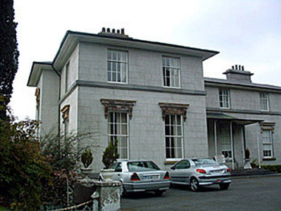
| Ladywell | Although much of the demesne of Harmony Hall is shown in the townland of Bunown on the first edition OS map, the house Ladywell was not built at this time. An elegant Italianate country house, six-bay two-storey over (partial) basement country house on L-shaped plan, built about 1845 to a design by Sandham Symes (1808-1894), for the Mahon Family (boi). In the mid-19th century Ross Mahon was the occupant holding the building valued at £37 in fee. Members of the Metge, Crofton, Williams and Flannery have all been occupants of this house. It has extensive views over Killinure Lough to the south. |
|
| Killinure House | Killinure House located close to the eastern shore of Lough Ree is an early 19th century house originally constructed by a branch of the Murray Family. Occupied by Alexander Murray in 1814 and by Major General Murray in 1837. It was later the home of the Maunsell Family in the mid-to-late nineteenth-century. Members of the Brereton and Metge families were residents in the 20th century. It was later the home of the Reid family who opened it as a hotel. The Glasson Lakehouse hotel resort is located there now. |

|
| Rossana House | Rossana House is named on the first edition OS map. It was built in the early 19th century but is not mentioned in Leet (1814). However, Lewis records Captain Stubbs as the occupant in 1837. By the time of Griffith’s Valuation Elizabeth Murray (nee Rushworth), widow of Major General James P Murray of Killinure House, was resident holding the property valued at £16.5 from Anne Stubbs who held the 30 acre townland from the King-Harmans. Members of the Murray family appear to have occupied the house during the rest of the 19th century. John and Ethel Hall were resident in 1901. Sold to the Sisters and Disciples of the Divine Master in the mid-1960s and demolished circa 1990 according to the list of Protected Structure for the county. | |
| Easthill House | Detached three-bay early nineteenth-century Regency villa, built in 1803. This house was originally built by a branch of the Handcock-Temple family of nearby Waterstown House and by 1814 was the home of Richard Cuppaidge, who is also recorded in 1837 as the occupant. John Cuppaidge was resident at the time of Griffith’s Valuation. The house was the property of the Clynes, Dolan and O’Shea families in the 20th century. |
|
| Harmony Hall | O’Brien writes that Harmony hall was built in 1788 by Colonel William Caulfield, a member of a branch of the Caulfield family, Earls of Charlemont. In 1842, Colonel John Caulfield sold the house to Arthur Dunn Chaigneau and purchased Bloomfield House, Mullingar. Griffith’s Valuation records Chaigneau as the occupant and that the house was valued at £50. The National Inventory of Architectural Heritage states that the house was built by the Handcock Temple family. Occupied by Edward Molony Gleeson of the Athlone Woollen Mills in the 1880s. Occupied by the Fox, Wilson and Fitzsimons families in the 20th century. |
|
| Waterstown House | This Palladian style country house on rectangular plan, constructed c.1745 was designed by the German architect Richard Castle (1695-1751) for Gustavus Handcock and his wife Elizabeth Temple. It has important historical connections with the Temple-Handcock family, who were originally granted the lands around Waterstown as payment for services to the Crown during the Cromwellian Wars (boi). Robert Handcock Temple was resident in 1814 and 1837. Valued at £47 in the mid-19th century it was occupied by Robert Holmes. The buildings had increased in value to £61.15 in 1906. It remained within the Temple-Handcock family until mid-1923 when they sold the estate to the Land Commission. In 1928 the pedimented doorcase at Waterstown was removed and re-erected at Lissglassick House (Longford) and the house became a ruin in the 1930s. |
|
| Ballaghkeeran House | Ballaghkeeran House marked on the 25 inch OS map but not on the earlier first edition map. This ‘mansion’ house was erected in the 1860s according to a Murtagh sale rental of 8 December 1876 which states that the sale included “a fine residence, erected within the last ten years, regardless of expense, built on an eminence affording commanding views of lake scenery … and approached from the public road by a handsome carriage drive, with ornamental iron gates and lodge at entrance’. Mrs Murtagh was the occupant at this time holding the house and nine acres as a tenant under the Court of Chancery. Members of the Murtagh family were still living in the house in 1901 and 1911. This house appears to be the residence of a farming enterprise. | |
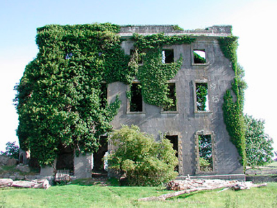
| Belville | O’Brien writes that Belville was built about 1775 for Richard Cuppaidge and by the early 1780s was occupied by the Jones family. It remained the Jones family home until at least the time of Griffith’s Valuation (publ. 1854) when Gustavus Jones Junior was resident. The house was valued at £23. It is now a ruin. | |
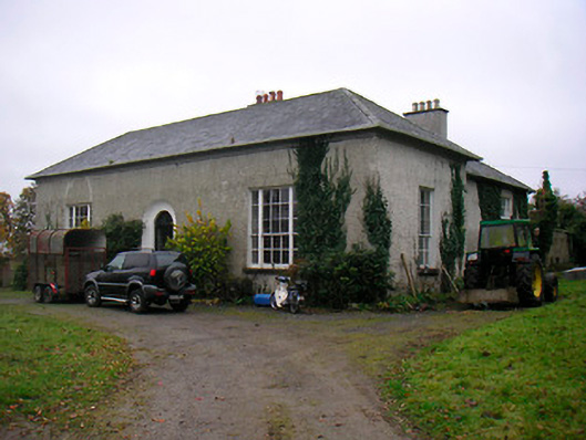
| Carn Park | Carn Park was built by the Adamson family in the late 18th century. Travers Adamson, son of William Gustavus Adamson was resident in 1814 and W G Adamson in 1837. At the time of Griffith’s Valuation (publ. 1854) the property was in Chancery, Robert Adamson was the occupant and the buildings were valued at £24. On 17 June 1870 when the house and lands were advertised for sale in the Land Court the house was described as a ‘commodious dwelling house (with suitable out offices) on Lot 1, which, although somewhat out of repair, is capable (at a moderate outlay) of being made a comfortable residence for a gentleman and his family. The house is prettily situated on the slope of a hill, commanding an extensive view’. It was bought by the Rev Thomas Thompson Gray of Dorrington, Drumraney, who was Vice Provost of Trinity College, Dublin, 1916-1924. The house was demolished in the mid-20th century. | |
| Coolvuck House | O’Brien writes that this early 19th century house was probably built by Francis Dillon, who was recorded as the occupant in 1814. Valued at £13 at the time of Griffith’s Valuation (publ. 1854), it was occupied by Eneas McDonnell who held the property from James George Murphy. Occupied by Thomas Groarke, a farmer and his sister in 1901 and by Thomas Killoughy, a shepherd who held it from Thomas Groarke in 1911. | |
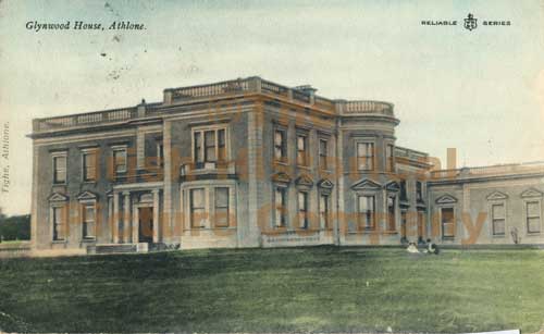
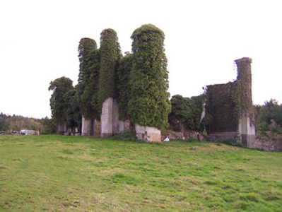
| Glynwood House | Glynwood house is located east of Athlone. The original house was constructed about 1790 by Francis Longworth and rebuilt about 1860 by John Longworth (1798-1881). A new house in the Italianate style was built in the early 1880s for Francis Travers Dames Longworth to the design of George Moyers. On 1 February 1918, a few lines in the Belfast News-Letter stated that Glynwood House, Athlone, the family mansion of the Dames-Longworth family, had been destroyed by fire. It is now an ivy covered ruin. See https://houseandheritage.org/2018/02/01/glynwood-house/ The present Glynwood House, formerly the agent’s house is located to the northwest of the site of the original Glynnwood House and dates from the late 19th century. |
|
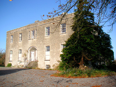
| Moydrum Castle | The National Built Heritage Service states that Moydrum Castle is a Gothic Revival castellated country house built circa 1812 to designs by Sir Richard Morrison (1767-1849), who was commissioned by William Handcock to rebuild an existing house befitting of his new status as Lord Castlemaine. Lewis describes it as ‘a handsome castellated mansion, erected in 1814’. It was valued at £75 in the mid-19th century. The building remained the home of the Castlemaines until it was burnt down on 3 July 1921. A photograph of the remains featured on the cover of the U2 album ‘The Unforgettable Fire'. |
|
| Twyford | Twyford House was originally built about 1760 by the Handcock Family of Waterstown House, Glassan, but passed into the ownership of the Hodson Family, at the end of the 18th century. In 1814 John Hodson was resident and E Hodson in 1837. Valued at £24 John Hodson was the occupant at the time of Griffith’s Valuation (publ. 1854), holding the property from John Longsworth. The Hodsons continued to reside at Twyford until it was sold about 1960. The house is now derelict. |
|
| Auburn House | Auburn House located on the eastern outskirts of Athlone town is described by O’Brien as a late 18th century, two-storey, three bay house built by James Sproule about 1790. Occupied by the Bruce family of Gore House, Northgate Street, for about fifteen years before they emigrated to Australia. W S Bruce was resident in 1837. At the time of Griffith’s Valuation (publ. 1854) Laurence or Lorenzo Dundas was resident, holding the house valued at £22 from George Mechum. in 1894 Slater noted it as the residence of George A.G. Adamson, J.P. Various persons occupied this house in the following years including the Mahon and Browne families in the 20th century. Sold to the state in the 1960s it became a ruin and is now demolished. The Athlone Regional College now occupies the site. | |
| Mountain View Cottage | This building is named as Mount View Cottage on the first edition OS map and Mount View on the 25 inch map. O’Brien writes that Mount View on the Moate road is a two-storey, three-bay Victorian house built by a Mr Vaughan in 1866. At the time of Griffith’s Valuation (publ. 1854) the previous house on this site, valued at £10, was occupied by Mrs Diana Sproule, who held the property from Robert Jameson. The present house was a McNamara home in the 20th century and is still extant. | |
| Creaghduff House | A building is marked at the site of Creaghduff House on the first edition OS map but the present house appears to have been built after this date. Gearoid O’Brien refers to Charles Handcock building the house at the time of Griffith’s Valuation (https://www.westmeathindependent.ie/2023/02/03/street-wise-coosan/). Valued at £17 as recorded in Griffith’s Valuation the house was occupied by the Hon Charles Handcock and held from Lord Castlemaine. It is located at the south west corner of Coosan Lough. Donal O’Brien writes that from the end of the 19th century Creaghduff was the home of Robert Degennes Levinge, a grandson of Sir Richard Levinge 4th Bt, and his descendants, who still live there. | |
| Creggan House | Creggan House, located just south east of Athlone town and south of Creggan Castle. This house is named on the first edition OS map. It was a two-storey, three-bay house built by the Longworth family in the early 19th century. Peter Longworth was a Cromwellian soldier who settled at Creggan Castle in the mid-17th century. The Longworth family continued to inhabit Creggan House for much of the 19th century, Francis Longworth being recorded as the occupant in 1837. Henry Norwood Trye was resident at the time of Griffith’s Valuation (publ. 1854), holding the house valued at £24 from his brother-in-law Francis Longworth. It was occupied by land agent Peter Metge and his family in 1901 and by widower Thomas Davies Longworth and his daughters in 1911. The house was burnt down in 1921 when occupied by a Major Montgomery and subsequently demolished. | |
| Woodville | Hawthorn Cottage is named on the first edition OS map and on the 25 inch map as Woodville. ‘The Cottage’ was the seat of William Cooke in 1837 and at the time of Griffith’s Valuation (publ. 1854) when the building was valued at £16 and held from Lord Castlemaine. O’Brien writes that the Bourke family were in possession in the late 19th and early 20th centuries. The house was demolished post 1950. The site is now among state and industrial buildings located on the east side of Athlone. | |
| Retreat | Retreat was a two-storey, three bay late 18th century house built by Thomas Cooke and located close to the east side of Athlone town. It was occupied by General Hart in 1814, F E Moony in 1837 and by Major Owen Lloyd Ormsby at the time of Griffith’s Valuation (publ. 1854), who held the property valued at £20 from William Cooke. Later occupants of this house were the Costello, Kilduff and Young families. The house and lands were sold to the Athlone Urban District Council in 1998 and the house demolished. | |
| Ardnagragh | Alicia Nugent was leasing this property, which included a mill, from the Digby estate at the time of Griffiths Valuation in the early 1850s, when it was valued at £23. The National Inventory of Architectural Heritage indicates that the house is still in use though the mill has been demolished. | |
| Dorrington House | At the time of Griffiths Valuation St. George Gray held this property in fee when it was valued at £32. It is labelled Dorrington House on all editions of the Ordnance Survey maps. In 1906 it was the property of Wellington Gray and valued at £44. O'Brien writes that the house was demolished during the twentieth century and a newer house constructed at the site but extensive estate architecture survives. |
|