Northlands
Houses within 10km of this house
Displaying 24 houses.
Houses within 10km of Northlands
Displaying 24 houses.
| House name | Description | |
|---|---|---|
| Shantonagh House | Lewis writes in the 1830s of Chantinee ‘in the demesne of which are some fine waterfalls’ the home of J. Tilly Forbes. In the early 19th century Chantinee or Chantony was visited by Maria Edgeworth on one of her tours when the house was occupied by James Corry. The first edition 6 inch Ordnance Survey map shows a house in the townland of Shantonagh but there is a larger house in the townland of Tooa which on the 25 inch map is named Shantonagh House. At the time of Griffith’s Valuation this house was valued at £25 and held by Thomas Rothwell in fee. It was burnt in early July 1921. | |
| Farm Hill | A house marked on the 1st edition Ordnance Survey map with a corn mill nearby. This house looks reduced in size on later maps. In the mid-19th century occupied by Hugh Swanzy and held from Thomas Rothwell. The house was valued at £15 with corn and flax mills and miller's house valued at £35. Part of the existing farmyard may date back to circa 1800. |

|
| Raferagh | A complex of buildings which included a house, corn mill, scotch mill and kiln were valued at £12 in the mid-19th century. Occupied by James Johnston they were located on the Shirley estate. This group of buildings is now much reduced in size. | |
| Derrylavan | A small building was located at this site on the 1st edition 6 inch Ordnance Survey Map (1836). The buildings were valued at £16 circa 1860 when William Lane was resident. He held 218 acres, about half the townland from Evelyn P. Shirley. Lough Fea was nearby. There was a milling complex a short distance away in the same townland. This house appears to be still extant. | |
| Belle Vue | This house is named on the 25 inch Ordnance Survey map (survey of 1908). It was built on the Shirley estate in the mid-19th century when it was occupied by John Thomas Holland and valued at £16. John Holland was appointed a magistrate by Lord Rossmore in 1854 (Dublin Evening Mail, 11 Oct 1854). Home of the Withrington in the early 20th century, now demolished. | |
| Shirley House | Shirley House located in the town of Carrickmacross is named on the 1st edition 6 inch Ordnance Survey Map (1836). It was the home of the agent, George Morant junior, in the 1840s and 1850s and was occupied by Shirley family members and others at various times, for example Alexander Mitchell in 1837 (Lewis, I, xlvii), Horatio Shirley of Shirley House was High Sheriff in 1872, John Thomas Holland of Shirley House died on 14 October 1881 aged 74 (The Belfast Morning News, 18 Oct 1881), Captain Evelyn Shirley was resident in 1914 and Felix Patrick Smith in 1925 (Thom’s Directory 1926). This house is now demolished. | |
| Lisanisk | Lisanisk is situated on the outskirts of Carrickmacross and close to Lisanisk Lake. In the 1780s it was inhabited by Walter Dawson whose daughter Sarah married Archibald Hamilton Rowan. The Post Chaise Companion in the early 19th century records a Mr Gibson at Lisanisk while Lewis in the 1830s names Adam Gibson. Edward Gibson was the occupant at the time of Griffith’s Valuation when the buildings were valued at £25 and held from the Marquess of Bath. The Patrician Brothers were occupying Lisanisk by 1911. This house was offering accommodation on a B&B basis in the 2010s. | |
| Drummond Cottage | Named on the 1st edition 6 inch Ordnance Survey Map (1836) this house with a farm of 125 acres was the home of the Kelly family in the mid-19th century. Thomas Kelly was resident holding the property from Mary Anne Kelly. Most of the townland belonged to the Porter family. A Mary Anne Jones Kelly of Priorland, Dundalk, owned 200 acres in county Monaghan in 1876. This cottage and its outbuildings date from the early 19th century and still survive. |
|
| Losset House | This house was built in the mid-19th century on the Shirley estate, close to Lough Fea Castle. It was valued at £8 and occupied by William Roarke. |

|
| Lough Fea House | Built in 1827 to the design of Thomas Rickman, this large house was the first residence of the Shirleys in county Monaghan, although they had owned a large estate since Elizabethan times. Lewis described this new edifice as ‘a spacious and handsome structure in the Elizabethan style of architecture’. A church and great hall were later additions. The buildings were valued at £180 circa 1860. The Shirley family continue to live at Lough Fea. | |
| Doohatty | A building named Cottage is marked on the first edition Ordnance Survey map (1836). It was located in the same townland as Lough Fea House, the home of the Shirley family. In the mid-19th century John Cooper was the occupant and the building was valued at £12. It appears to still be extant. | |
| Lough Bawn House | Situated close to the shore of Lough Bawn a building at this location has been home to the Tenison family for three centuries. A family member now runs a forestry farm at Lough Bawn. Much of the original house built circa 1760 was destroyed by fire in the late 18th century. The present house dates from the early 19th century and incorporates some of the earlier building with subsequent enlargements. Lewis records the occupant as W. Tenison and Griffith’s records the house, valued at £30, as unoccupied. Still valued at £30 in 1906 when this house was occupied by Major William Tenison. |

|
| Derrygoony | A house associated with the milling business of Richard Allen Minnett who held the property in fee. It is mentioned by Samuel Lewis in his topographical dictionary of 1837. The buildings, which included a house, offices and flax mill, were valued at £35 in the mid-19th century. The house is named on the 25 inch Ordnance Survey map. In 1901 and 1911, the house was occupied by Patrick Connolly, a farmer and mill proprietor and his family. The site is now planted with trees. | |
| Bailieborough Castle/Lisgar Castle | A Scottish planter named William Bailie built a castle here in the early 17th century. It passed into the possession of a number of prominent families Hamilton, Stewart and Corry until it was sold to Colonel William Young in 1814. His son, Sir John Young, later created 1st Baron Lisgar, built a new house on the site in the 1860s. At the end of the 19th century the house was sold to Sir Henry Cochrane and in 1915 to the Marist Brothers of Athlone. Badly damaged by fire in 1918 but reconstructed, the house was eventually demolished in 1942. For image see https://www.archiseek.com/ | |
| Beckscourt House | Becks Court, located just outside the town of Bailieborough on the Young estate, was occupied by the Reverend Arnold Cosby in 1814. Lewis records the Reverend E. Mahaffy as resident. By the mid-19th century it was occupied by Sarah Mahaffy who held the property from Sir John Young of Bailieborough Castle. The buildings were valued at £12. | |
| Spear Vale/Vale House | In 1814, Ambrose Leet refers to William Spear of Spear Vale, Bailieborough. In 1837, Lewis described the home of W. Spear as comfortable with an extensive bleach green about one mile from the town. The Reverend Frederick FitzPatrick occupied the house in the mid-19th century holding it from William Spear. The buildings had a rateable valuation of £12. This house is no longer extant. | |
| Cabra Cottage | This house was the home of the Pratt family until Cormey Castle was purchased in 1813 and was renamed Cabra Castle. Cabra Cottage is shown on the first edition six inch Ordnance Survey map (publ. 1837) as a substantial building close to a mill race, quarry and the ruins of the first Cabra Castle. Bence Jones describes this building as an early 18th century villa possibly designed by Sir Edward Lovett Pearce. He writes that it was used as a ballroom following the Pratts move to live in their new home in Cormey. In the mid-19th century it was valued at £20 for rates and Colonel Joseph Pratt was the owner and occupier. The 25 inch map shows the building much reduced in size. Bence Jones writes that it was destroyed by fire in the 1950s. | |
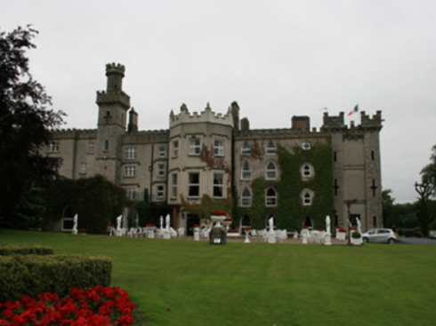
| Cabra Castle | The second Cabra Castle, probably incorporating the old Cormey Castle, was complete by the late 1830s. It is located on the county border between Cavan and Meath. A castellated building of Gothic appearance Cabra Castle had a rateable valuation of £70 in the mid-19th century when occupied and owned by Colonel Pratt. It continued to be the main residence of the Pratts until the mid -0th century when it was inherited by a relative, Mervyn Sheppard, who sold it in the mid-1960s. It now functions as a hotel. https://www.cabracastle.com/ |
|
| Corrinshigo House | Corrinshigo House was located to the west of the other two Pratt homes, Cabra Cottage and Castle. It is named on the first edition six inch Ordnance Survey map (publ. 1837). Lewis records it as the residence of J. Pratt and Griffith’s Valuation records Francis Pratt as the occupier holding the property from Frances E. Pratt. It had a rateable valuation of £15. Occupied by George Pratt and his mother in 1901. Now a green field site. | |
| Mullantra | Mullantra was located on the border between counties Cavan and Monaghan and north of the other Pratt homes in the locality. In 1814 it was occupied by James Butler Pratt. Lieutenant Edward Pratt of Mullantra, Kingscourt, petitioned the Lord Lieutenant in 1822 for an appointment to a post in the police establishment (National Archives CSO/RP/1822/1006). By the time of Griffith’s Valuation this building, the property of Colonel Pratt, had a rateable valuation of £2 and was vacant. A new building appears on a nearby site on the 25 inch map and is still extant in the middle of a forestry area. | |
| Inver Lodge | Henry Edward Porter held a house in fee, valued at £14, in Magheross on the outskirts of Carrickmacross, circa 1860. This appears to be Inver Lodge which is named on the first edition Ordnance Survey map (publ. 1836). This house is still extant. | |
| Farm Hill (Reduff) | A house marked on the 1st edition Ordnance Survey map with a corn mill nearby. This house looks reduced in size on later maps. Described in the Ordnance Survey Field Name Book as a ‘small 2 storied house with some scattered portions of plantation around it and extensive corn mill nearby’, occupied by ‘Mr Robinson’. In the mid-19th century occupied by Hugh Swanzy and held from Thomas Rothwell. The house was valued at £15 with corn and flax mills and miller's house valued at £35. Part of the existing farmyard may date back to circa 1800. This house and its yard buildings are now part of a working farm. |
|
| Heath Lodge | Heath Lodge in a small demesne is named on the first edition six inch Ordnance Survey map (publ. 1837). Griffith’s Valuation records Garret Williamson as the occupant holding the property from Edward Wilson Nesbit. It was valued at £11 for rates. This house was not occupied in the early 20th century. | |
| Shinan House | Shinan House was the home of a branch of the Adams family from the early 19th century. Lewis records ‘Shenan’ as the residence of E. Wilson. By the mid-19th century it was valued at £50 and was owned and occupied by Captain Benjamin Adams. Charles Adams was in possession of Shinan House in the early 20th century. It was later demolished. |