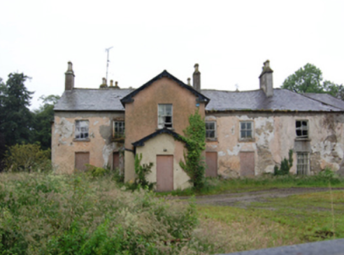
Lake View (Scrabby)
Houses within 10km of this house
Displaying 15 houses.
Houses within 10km of Lake View (Scrabby)
Displaying 15 houses.
| House name | Description | |
|---|---|---|
| Riverview/Cloggy House | River View was situated on the bank of the River Erne. It was obviously associated with linen making in the early 19th century as beetling and bleaching mills are both marked near the house on the first edition six inch Ordnance Survey map (publ. 1837). A corn mill is also shown nearby. The Faris family were resident in Cloggy from at least 1832 when Alexander Faris is mentioned in the Tithe Applotment Books. In the mid-19th century William Faris was resident holding the buildings valued at £15 from Cosby Thomas Nesbitt. Alexander Faris/Ferris, a farmer and his family were living in Cloggy at the beginning of the 20th century. This house has been modernised and still retains a fine range of outbuildings. | |
| Laurel Bank/Holly Bank | This house, originally known as Laurel Bank, is named on the first edition six inch Ordnance Survey map (publ. 1837). It is shown in a demesne which included an old bleach mill and a corn mill and kiln. It is believed to have been built by a mill owner in the 18th century. Griffith’s Valuation records William Norton as the occupant holding the property valued at £8.10.0. from the Earl of Gosford. The house is called Holly Bank on the 25 inch map. Altered and added to in the 20th century it continues to be a residence. | |
| Gartinadress House | In 1814, Charles Veaitch was the resident at Gortin-ardrass. This house is named on the first edition six inch Ordnance Survey map (publ. 1837). Although having advertised Gartinardress for sale in 1850 William Young was the owner and occupier at the time of Griffith’s Valuation when the property was valued at £15 for rates. By the early 20th century the Armstrong family were occupying Gartinardress, although in 1906 William A. K. Young is recorded as occupier of 228 acres of untenanted land and the mansion house. This house is no longer extant and the site is part of a forestry area. A house known as Lakeville was also located in the townland of Gartinardress. Leases in the National Library record Lakeville as the home of Richard Young in the 1820s. It was described as ‘in ruins’ on the 25 inch map. | |
| Tully House (Killashandra) | Richard Young of Tully 1808, see GO MS. Richard Young and his wife Bridget Nugent Reynolds later lived at Fort Lodge, on the outskirts of Cavan town. In 1814, Mr R.Y. Reynolds was resident at Tully, Crossdoney. Major Randal Stafford of Tully House, Crossdoney, is listed as a subscriber to Lewis ‘Topographical Dictionary’ (1837). In the 1850s this house was occupied by William Magee who held it from the representatives of Hugh Walsh. The Douglas family were resident at the beginning of the 20th century. | |
| Bruce Hall | Thomas Hinds of Prussia Street, Dublin and previously of Bruce Hall, county Cavan, died in 1794. Henry B. Wilson was resident at Bruice-hall, Arva, in 1814. Bruce Hall was the home of John Warren in the mid-19th century. John Warren married Isabella, daughter of Captain James Blakely of Lake View, county Cavan, in 1856 (Anglo-Celt, 28 August 1856). He held Bruce Hall from Robert Burrowes and it was valued at £10 for rates. | |
| Corstruce House | A house located on the outskirts of Bellananagh and near a corn mill. It was situated on part of the Fleming estate and was occupied by William Pollock in the mid-19th century and was in the possession of Thomas Brady in the early 20th century. A modern house now occupies this site. | |
| Lismore Lodge | Built as the agent’s house in the Nesbitts’ Lismore Castle demesne close to the village of Crossdoney. Lismore Lodge is named on the first edition six inch Ordnance Survey map (publ. 1837). It was the home of William Tatlow in the mid-19th century, when the buildings were valued at £20. Occupied by the family of Thomas Cosby Burrowes at the beginning of the 20th century. His mother Mary Anne Burrowes had succeeded to the Lismore estate in 1886 following the death of her brother Alexander Nesbitt. Under boundary changes at the end of the 19th century the location of the Lodge was changed to the townland of Lismore Demesne and it was valued at £32 for rates in 1906. In the mid-20th century it was a Lucas-Clements home. This house is extant but unoccupied. |
|
| Drumcarban | Bence Jones describes Drumcarban as a late 18th century house of 3 storeys and 3 bays. It was the home of the Bell Booth family in the 19th century. George Thomas Bell Booth was resident in the 1830s and 1840s until he was murdered in 1845. Robert Booth Bell was the owner and occupant at the time of Griffith’s Valuation. This house was occupied by Annie Sheridan in 1901, in 1906 by Michael Sheridan when it had a rateable valuation of £22.5.0. and is still extant. | |
| Lismore Castle | An early 18th century house, possibly designed by Sir Edward Lovett Pearce (Bence Jones). Named on the first edition six inch Ordnance Survey map (publ. 1837), it was valued at £12 for rates in the mid-1850s. It was a Nesbitt family home until the 1880s when inherited by the Burrowes family and passed from them by marriage to the Lucas Clements in the 1920s. However the house was marked as ‘in ruins’ on the 25 inch map. Bence Jones records that it was later demolished and that the Lucas-Clements resided in the agent’s house nearby Lismore Lodge. | |
| Dalystown House | Francis Tuite was leasing this property from the Thornton estate at the time of Griffiths Valuation, when it was valued at over £10. In the 1870s it was recorded as the address of Laurence Reynolds. This property is labelled Rockfield House on the 1st edition Ordnance Survey map but as Dalystown House on the 25-inch map of the early 20th century. In 1906 it was still in the ownership of Laurence Reynolds and valued at almost £23. The National Built Heritage Service suggests 1820 as a building date for the surviving farmyard complex. Dalystown House has been demolished. |
|
| Cornadrung Cottage | In 1906 the report on Untenanted Demesnes notes a property at Cornadrung in the possession of Edward Fitzgerald and valued at over £10. This house is labelled Cornadrung Cottage on all editions of the Ordnance Survey map. It appears to have begun as a small property, possibly a hunting lodge on the shores of Lough Gowna which was enlarged in the latter part of the 19th century. In the 1870s Cornadrung was recorded as the address of Mrs. Sarah Hughes. Family history sources suggest it was later owned by the Cole family. The site is now occupied by a modern house. | |
| Derrycassan House | John Dopping held this property in fee at the time of Griffiths Valuation in the early 1850s, when it was valued at £36. Burke suggests it had been a D’Arcy property until the marriage of Alice D’Arcy to Anthony Dopping in the 18th century. It was in the ownership of Capt. J.D.L. Hepenstal and valued at £50 in 1906. Derrycassan House was acquired by the Forestry Service. The house was demolished and some of the stone used in the construction of St. Columba’s RC church not far away. Other estate architecture remains and there are woodland walks in the estate. | |
| Frankford House | Reverend Patrick Ratigan was leasing this property from Edward McEvoy’s estate at the time of Griffiths Valuation in the 1850s, when it was valued at £14. It held the same valuation when first valued in 1839. At that time it was occupied by Nathaniel O'Reilly. It is not extant now. | |
| Erne Head | In 1837 Lewis referred to “Kilrea” as the seat of H. Dopping . Henry Dopping held this property in fee at the time of Griffiths Valuation in the 1850s when it was valued at £15. It is labelled Erne Head on the 25-inch Ordnance Survey map of the early 20th century. The house at Culray was the property of Reverend Francis Dopping in 1906 when it had a valuation of almost £18. It is no longer extant. | |
| Woodville (Granard) | Richard Lambert held this property in fee at the time of Griffiths Valuation, when it was valued at £16. In 1839 the Valuation Office books also note Lambert as the occupier of the property which was then valued at £12. The house survived into the twentieth century but is no longer extant. |