Lake View (Munterconnaught)
Houses within 10km of this house
Displaying 15 houses.
Houses within 10km of Lake View (Munterconnaught)
Displaying 15 houses.
| House name | Description | |
|---|---|---|
| Cornashesk House | This house was not built at the time of the first Ordnance Survey in the 1830s. It was erected within the demesne of Fort William and was occupied in the 1850s by David Kellett and held from the trustees of the Marquess of Headfort. It was valued at £10. Home of the Farrelly family at the beginning of the 20th century. | |
| Fort William (Cornashesk) | A house and outbuildings are marked on the first edition six inch Ordnance Survey map (publ. 1837). Leet records Charles Kellett as the occupant of Corna-sesk in 1814. The house, which had expanded, is named on the 25 inch map. Fort William was the home of Robert Kellett in the 1850s, held from the Marquess of Headfort and valued at £14. Fortwilliam, Virginia, was the home of Ralph Harman in 1876. It is still extant. | |
| Lurgan Lodge | Lurgan Lodge was the residence of a branch of the Nixon family from the late 18th century. George Nixon of Lurgan Lodge was the fourth son of the Reverend Andrew Nixon of Nixon Lodge. George’s son, Andrew Nixon, lived here in 1814. Lurgan Lodge is named on the first edition six inch Ordnance Survey map (publ. 1837). There was a corn mill nearby. The estate of Eliza Nixon of Lurgan Lodge was advertised for sale in the Encumbered Estates Court in March 1852. Her estate was held on a 21 year lease from the Bishop of Kilmore, dated 1849. James Hunter was one of the plaintiffs. In the mid-19th century the house was occupied by John Jennings and held from James Hunter. The buildings had a rateable valuation of £15. John Jennings was described as a farmer and miller when he died in 1867 (NA, Wills and Administrations 1867, 105). In the early 20th century Lurgan Lodge was the home of Thomas Charles Kellett, a farmer and magistrate. It is still extant. | |
| Cornahilt Lodge | Located on the outskirts of Ballyjamesduff, Cornahilt Lodge was occupied by Mary Skelton in the mid-19th century. She held the property with a rateable valuation of £12.10.0. from Robert J. Cuming. Cornahilt Lodge is now the address of a services company based in Ballyjamesduff. | |
| Fort Frederick | Fort Frederick situated close to the shore of Lough Ramor was described by Bence Jones as ‘a 2 storey mid-c18 house with a central 3 sided bow and 2 bays on either side of it’. In 1814 it was the home of Captain Sankey but by 1837 had been acquired by his relative R. Scott who was married to Eleanor Sankey. Griffith’s Valuation records Richard Scott as the occupier. The buildings were valued at £35 and were held in fee. By 1876 Alexander William Jackson Sankey owned the Fort Frederick estate, comprised of 1,324 acres. He died in 1903. His brother Harry Samuel Sankey is recorded as resident at Fort Frederic in 1910. This house continues to be a residence. |

|
| Mountprospect | A Nugent family home until the mid-19th century when it passed into the possession of Richard Dempsey. Eliza Dempsey, a widow, was resident in 1901. This house no longer exists. | |
| Kilnacrott Cottage/House | In 1837 Lewis records Pierce Morton as the proprietor of Kilnacrott. This was Kilnacrott Cottage as marked on the first edition 6 inch Ordnance Survey map (publ. 1837). Subsequently a Tudor Revival house was built very slightly to the north of the Cottage for Pierce Morton (National Inventory of Architectural Heritage). Morton sold the house in 1850 to Samuel Moor, who sold it on privately to William Hague. This house had a rateable valuation of £65 at the time of Griffith’s Valuation and was occupied by George H. L’Estrange who held the property from William Hague of Cavan, father of William Hague, architect of Cavan and Dublin. In 1876 William Hague held 459 acres in county Cavan. In the 1880s Kilnacrott became the home of the Lynch family. In 1906, Charles Lynch was resident. He died in 1913 (see will administrations in the National Archives). From 1930 the building was used as a school by the Holy Trinity Priory. In 1954 a grant of arms was issued to the Rt Reverend Felim Cornelius Colwell, Lord Abbot of the Abbey of the Holy Trinity of the Canons Regular of Premontre at Kilnacrott, Co Cavan, and to the Community, see National Library, GO MS 111H: 27-28. Kilnacrott is now known as the Cavan Centre, a ‘Residential Centre for Education and Community Development’, see http://www.cavancentre.ie/ | |
| Dungummin House | Dungummin House with a very small demesne is named on the first edition six inch Ordnance Survey map (publ. 1837). In 1814 Leet records John Ingham of Dungimmon, Mount Nugent. Joseph Lynch was the occupier recorded in Griffith’s Valuation. He held the property, described as a herd’s house and valued at £12.10.0., from Thomas Whitney. Michael Palles Lynch of Dungimon, county Cavan and of Coola, county Westmeath, sixth son of Joseph Lynch of Roebuck House, county Cavan, is recorded in Walford’s 1910. | |
| Lisnabrin | This house, located on the outskirts of Mount Nugent, was built after the first edition six inch Ordnance Survey map (publ. 1837) was compiled. John Love was the occupant in the 1850s, holding the property, valued at £13, from the Most Reverend J.G. Beresford. A Lynch family home at the beginning of the 20th century and still a residence. |
|
| Roebuck | Roebuck was a Lynch home from at least the early 19th century when Edward Lynch was recorded as resident in 1814. Lewis records W. Reilly as the proprietor of Roebuck. In the 1850s Joseph Lynch was the occupant recorded in Griffith’s Valuation, when the buildings were valued at £15 and held from the Representatives of William O’Reilly Adams. By 1906, Henry Galligan was occupying this 'mansion' house valued at £15 for rates and 365 acres of untenanted land. | |
| Billis Grange | A house built after the first edition six inch Ordnance Survey map (publ. 1837) was surveyed. Mrs D. Delap was the owner and occupier in the mid-19th century when the buildings were valued at £13. There is a reference to W.C. Peyton of Billis Grange in a document in the Farnham Papers, Ms 11,499 (NLI). The building was possibly extended towards the end of the 19th century. The National Inventory of Architectural Heritage dates the present house c. 1890. The 25 inch map shows a substantial house in parkland with a lodge at the entrance gate. In 1906, Henry Sankey held over 300 untenanted acres in this locality including a building with a rateable valuation of £16.10.0. This house continues to be a family residence. |
|
| The Lodge | A sporting lodge built by the Taylour family before 1800 and originally known as Cottage. It was extending circa 1820 and again circa 1860. It is situated close to Lough Ramor and on the outskirts of the town of Virginia. The Lodge was valued at £37 in the 1850s when the Earl of Bective was recorded as the occupant. By 1906, the rateable valuation had risen to £105. The building now functions as a hotel, see http://www.virginiaparklodge.com/ |

|
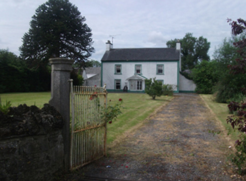
| Lakeview (Mullagh) | The nucleus of this house is believed to date back to the mid-17th century and since that time has remained in the possession of the Mortimer family and their descendants. Leet lists David Mortimer as resident and Lewis records Lakeview as a Mortimer home. Griffith’s Valuation names Charles Mortimer as the occupant and owner. The buildings were valued at £11. In 1906, David A Mortimer held about 500 acres of untenanted land and buildings valued at £11.15.0. Since the mid-1990s Lakeview has been the home of Jonathan and Daphne Shackleton and they have restored the gardens. |
|
| Quilca House | Quilca was associated with the Sheridan family. The Reverend Thomas Sheridan was a friend of Dean Swift. In 1725 the Dean wrote some of ‘Gulliver’s Travels’ while staying with the Sheridans at Quilca. In 1814 Robert Doughty was resident and the Reverend Luke O’Reilly in the 1830s. No occupant is given in Griffith’s Valuation when the building was described as a herd’s house and was valued at £5. Joseph Le Fanu was the immediate lessor. A mid-20th century house now occupies the site. | |
| Eighter | On the first edition six inch Ordnance Survey map (publ. 1837) Eighter House, part of the estate of the Marquess of Headfort, is shown as set in a small demesne close to the shore of Lough Ramor. Henry Sargent was the occupier in the mid-19th century when the buildings were valued at £16. In the 1870s Eighter was the home of John Alexander Johnston, who owned 111 acres in the county in 1876. He was medical doctor and his wife had a connection with the Sargent family. Home of Michael M’Enroe in the 1920s. It appears to be extant. References to Eighter in the Small Private Collections of Cavan Library's Archives Service, P017/0084, P017/0104, P017/0125 & P017/0166. |