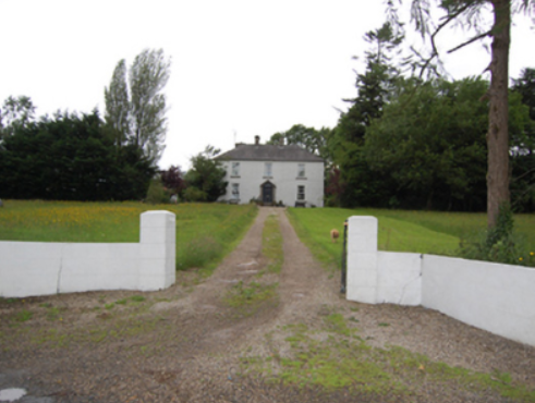
Rockfield (Killashandra)
Houses within 10km of this house
Displaying 32 houses.
Houses within 10km of Rockfield (Killashandra)
Displaying 32 houses.
| House name | Description | |
|---|---|---|
| Druminshin Glebe | Rev. James Agar held this property at Druminshin Glebe freehold at the time of Griffith's Valuation when it was valued at £30. The property seems to have been known as Carrigallen Glebe or Carrigallen Lodge at various times though it is recorded as Druminshin Glebe house on the first edition Ordnance Survey map. It is still extant and occupied. |
|
| Kilbracken | William Murray Hickson was leasing the house at Kilbracken, barony of Carrigallen, from Elizabeth Armstrong at the time of Griffith's Valuation when it was valued at £20. In 1814 a house at Kilbracken was recorded as the residence of Mr. Armstrong but it has been estimated that the present Kilbracken House was built around 1825. It is not named on the first edition Ordnance Survey map though there are buildings marked on the site. A poster in Leitrim County Library indicates that it was the property of Thomas S.Jones in 1905 when it was offered for sale. The house is still extant and undergoing restoration. |
|
| Killygar | It is estimated by the National Inventory of Architectural Heritage that Killygar was built in 1813. At the time of Griffith's Valuation Killygar House was occupied by John Godley and was valued at £43. It was also the residence of John Godley in 1814 and in 1837. In 1894 Slater refers to it as the seat of Archibald Godley. It is still extant and occupied by the Godley family. |
|
| Cloghlough | At the time of Griffith's Valuation, William O'Brien was leasing a property valued at £8 at Cloghlough, barony of Carrigallen, from the estate of John King, which was in Chancery. Substantial farm buildings exist at this site. | |
| Drumsillagh | Acheson O'Brien was leasing the property at Drumsillagh, barony of Carrigallen, from the King estate (in chancery) at the time of Griffith's Valuation when it was valued at £15. Lewis also records it as a seat of the O'Brien family in 1837. In 1906 Drumsillagh was owned by the representatives of William A. O'Brien and was also valued at £15. There appears to be still a house at this site. | |
| Clooncorick Castle | Formerly an O'Rourke castle, Clooncorrick was held by several other families, notably the Irwins, before being bought by Pierce Simpson in 1835. In 1814 it is recorded as the residence of Rev. Agar. At the time of Griffith's Valuation it was being leased by Pierce Simpson from the Ormsby Gore estate and was valued at £40. Lewis also records it as the seat of the Simpson family in 1837. In the 1930s the castle was dismantled and the fittings sold. The ITA survey in the 1940s recorded that the castle had recently been demolished. | |
| Nixon Lodge/Griffith Lodge | A mid-18th century house, named Nixon Lodge on the first edition 6 inch Ordnance Survey map (publ. 1837). It was the home of the Reverend Andrew Nixon and his wife Marianne French of Frenchpark, county Roscommon, in the 18th century. Their son Humphrey had eight children. Nixon Lodge was later known as Griffith Lodge and Griffith’s Valuation records Dorothea Griffith as the occupant. She held the property in fee and the buildings were valued at £16.10.0. Occupied by the Smith family at the beginning of the 20th century. Somewhat reduced in size this house is still extant and occupied. | |
| Greenville (Cavan) | The Thorntons were located at Greenville from the 18th century. The house was situated east of Greenville Lough and north of Ardlougher. At the time of Griffith’s Valuation the buildings described as a house, steward’s house, offices and lodge were valued at £40 for rates. The property was held by Perrott Thornton in fee. In 1864 the Greenville estate of William Robert Thornton was advertised for sale in the Landed Estates Court including the house and demesne. In 1876 George Nugent, the owner of 400 acres in county Cavan, is recorded as resident at Greenville, Ardlougher. His estate including Greenville was for sale in November 1880 when the house was described as 'handsome, modern, substantially built, in excellent order, well supplied with water, and fit for the immediate reception of a large family'. The home of Lieutenant Colonel William Alexander Crawford Roe and his wife Emma in 1901 and of the Clifford sisters Olivia and Edith in 1911. In 1906, it was described as a 'mansion' with a rateable valuation of £40. The house is no longer in existence. | |
| Carn Cottage | Griffith’s Valuation records Captain Richard Clifford as owner and occupier and the building was valued at £28.15.0. At the beginning of the 20th century this house was the home of [retired] Lieutenant General Robert Cecil Richard Clifford, Indian Staff Corps and his wife and daughter. http://bygonedaysphotography.blogspot.ie/2016/08/two-clifford-sisters.html |
|
| Carn House | Leet records William Benison of Carn, Killeshandra, in 1814 and Lewis refers to J. Benison of Carn in 1837. The first edition six inch Ordnance Survey map (publ. 1837) shows two houses within the demesne at Carn, named Carn House and Carn Cottage. A new house on a new site is named Carn House on the 25 inch map (H296136). By the time of Griffith’s Valuation Moses Netterfield held the property valued at £15.10.0., including a house and herd’s house, from Captain Bedel Stanford. Part of the house appears to be still occupied. | |
| Lake View House (Drumlane) | Home of Richard J. ‘Hynes’ (Hinds) at the time of Griffith’s Valuation, Lake View House was held in fee and had a rateable valuation of £10. It was built after the first Ordnance Survey of the 1830s and before the primary valuation survey. Henry Hinds in 1901 and Mrs Charlotte E. Hinds in 1911 held a vacant house in Deramfield. Lake View House is presently occupied. |
|
| Bilberry Hill | William Stanford of Bilberry Hill was High Sheriff of county Cavan in 1774. This house was the home of the Irwin family from at least 1790 when Daniel Irwin of Bilberry Hill married a Miss E. Faris of Cloncorick. Leet records David Irwin as resident in 1814 and Jane Elvin [Irwin] was the occupant in the 1850s holding the property valued at £10.10.0. from Thomas Irvine [Irwin]. Jane Irwin died at Bilberry Hill in 1876 (Cavan Weekly News, 28 July 1876). The Irwins were succeeded by the Berrys of Berrymount to whom they were related. This house is no longer extant. | |
| Mackan | William Faris was resident at ‘Mackin’ in 1814. Lewis records Mackenwood as the home of M. Galbraith. It was part of the estate of William James Thomas Galbraith advertised for sale on in 1851 and 1852. At the time the building was described as a 'thatched house of two stories, not in good repair but as the out-offices are excellent and the lawn and aspect cheerful, it would suit for a Gentlemen's residence'. In the 1850s Captain John Johnston was the owner and occupier. The building was valued at £7 for rates. The house is marked as ‘in ruins’ on the 25 inch map but the stable block is still extant. | |
| Aubawn | Described by Mulligan as a ‘medium-size Late Georgian villa’. In 1814 Henry Lenauze was resident at Aubawn, Killeshanadra and Lewis records Aughabawn as the home of the Reverend J. Vernon. The Upton Papers (RIA) contain the will of M. Story of Aubawn, 1817. By the mid-1850s Richard Fox was the owner and occupier of Aubawn, with a rateable valuation of £21. In 1876 the address of George De La Poer Beresford, owner of 570 acres in the county, was Auburn, Killeshandra. Douglas G. Adams occupied the house in 1901, holding it from Beresford while a land steward William Gordon and his family were resident in 1911. This house has been renovated and modernised. |
|
| Croaghan House | A small house named on the first edition six inch Ordnance Survey map (publ. 1837). The building was later extended and in the mid-1850s was occupied by the Reverend Allan, who held it from Richard Carson. It was valued at £11. David Hamill Crawford, land agent, and family were resident in the early 20th century, this building appears to be still extant. | |
| Drummully House | In the mid-19th century a house valued at £10 was owned and occupied by Catherine Dickson in Drumully East. By the early 20th century a substantial house named Drom Mullac is shown on the 25 inch map when the Lough family were resident. There are references to Albert Hutton of Drummully House, Killashandra in 1876; Mrs Louisa Frances Hickson, widow of William Murray Hickson in 1884 and Thomas Lough MP of Drummully in 1898. This house became a convent and was demolished in 2012. | |
| Riverview/Cloggy House | River View was situated on the bank of the River Erne. It was obviously associated with linen making in the early 19th century as beetling and bleaching mills are both marked near the house on the first edition six inch Ordnance Survey map (publ. 1837). A corn mill is also shown nearby. The Faris family were resident in Cloggy from at least 1832 when Alexander Faris is mentioned in the Tithe Applotment Books. In the mid-19th century William Faris was resident holding the buildings valued at £15 from Cosby Thomas Nesbitt. Alexander Faris/Ferris, a farmer and his family were living in Cloggy at the beginning of the 20th century. This house has been modernised and still retains a fine range of outbuildings. | |
| Drumgoon | The houses known as Drumgoon, Lahard, Gartinadress and Lakeville are in close proximity to one another and all at one time were homes of the Young family. Drumgoon is located just east of Lahard. In the mid-19th century it was the residence of James Robinson, who held it from Robert Hutton when it had a rateable valuation of £6.10.0. This house is still extant. | |
| Laurel Bank/Holly Bank | This house, originally known as Laurel Bank, is named on the first edition six inch Ordnance Survey map (publ. 1837). It is shown in a demesne which included an old bleach mill and a corn mill and kiln. It is believed to have been built by a mill owner in the 18th century. Griffith’s Valuation records William Norton as the occupant holding the property valued at £8.10.0. from the Earl of Gosford. The house is called Holly Bank on the 25 inch map. Altered and added to in the 20th century it continues to be a residence. | |
| Gartinadress House | In 1814, Charles Veaitch was the resident at Gortin-ardrass. This house is named on the first edition six inch Ordnance Survey map (publ. 1837). Although having advertised Gartinardress for sale in 1850 William Young was the owner and occupier at the time of Griffith’s Valuation when the property was valued at £15 for rates. By the early 20th century the Armstrong family were occupying Gartinardress, although in 1906 William A. K. Young is recorded as occupier of 228 acres of untenanted land and the mansion house. This house is no longer extant and the site is part of a forestry area. A house known as Lakeville was also located in the townland of Gartinardress. Leases in the National Library record Lakeville as the home of Richard Young in the 1820s. It was described as ‘in ruins’ on the 25 inch map. | |
| Lahard | Lahard was the home of the Young family in the 18th and 19th centuries. It is named on the first edition six inch Ordnance Survey map (publ. 1837) which shows a flower garden to the south of the house. Occupied by Cosby Young in 1814 and by John Lough in the 1850s, who held the property from the representatives of Cosby Young. The buildings were valued at £10. Inherited by one of Cosby Young’s daughters, Mrs Mackarness. The railway line was erected to the south west of this house. It is no longer extant. | |
| Tully House (Killashandra) | Richard Young of Tully 1808, see GO MS. Richard Young and his wife Bridget Nugent Reynolds later lived at Fort Lodge, on the outskirts of Cavan town. In 1814, Mr R.Y. Reynolds was resident at Tully, Crossdoney. Major Randal Stafford of Tully House, Crossdoney, is listed as a subscriber to Lewis ‘Topographical Dictionary’ (1837). In the 1850s this house was occupied by William Magee who held it from the representatives of Hugh Walsh. The Douglas family were resident at the beginning of the 20th century. | |
| Bruce Hall | Thomas Hinds of Prussia Street, Dublin and previously of Bruce Hall, county Cavan, died in 1794. Henry B. Wilson was resident at Bruice-hall, Arva, in 1814. Bruce Hall was the home of John Warren in the mid-19th century. John Warren married Isabella, daughter of Captain James Blakely of Lake View, county Cavan, in 1856 (Anglo-Celt, 28 August 1856). He held Bruce Hall from Robert Burrowes and it was valued at £10 for rates. | |
| Castle Hamilton | In the mid-18th century Castle Hamilton came into the possession of the Southwell family through marriage with a Hamilton co-heiress. It remained in Southwell ownership until about the 1840s. Both Leet and Lewis record members of the Southwell family as resident. Lewis describes the house as ‘a spacious mansion surrounded by an extensive and highly embellished demesne’ adjoining the town of Killeshandra. The buildings were valued at £50 in the mid-19th century, by which time James Hamilton was owner and occupier. The Hamiltons were still resident at the time of the censuses of 1901 and 1911. The house was accidentally destroyed by fire in 1911 but a fine farm yard survives. |

|
| Portaliff House | Portaliff House was located on the Castle Hamilton estate, north of Mill Lough and a little south of Killashandra. In the mid-19th century it was occupied by Captain F.H.B. Philips when it was valued at £12 for rates. Portaliff House is listed as a protected structure. | |
| Lismore Lodge | Built as the agent’s house in the Nesbitts’ Lismore Castle demesne close to the village of Crossdoney. Lismore Lodge is named on the first edition six inch Ordnance Survey map (publ. 1837). It was the home of William Tatlow in the mid-19th century, when the buildings were valued at £20. Occupied by the family of Thomas Cosby Burrowes at the beginning of the 20th century. His mother Mary Anne Burrowes had succeeded to the Lismore estate in 1886 following the death of her brother Alexander Nesbitt. Under boundary changes at the end of the 19th century the location of the Lodge was changed to the townland of Lismore Demesne and it was valued at £32 for rates in 1906. In the mid-20th century it was a Lucas-Clements home. This house is extant but unoccupied. |
|
| Drumcarban | Bence Jones describes Drumcarban as a late 18th century house of 3 storeys and 3 bays. It was the home of the Bell Booth family in the 19th century. George Thomas Bell Booth was resident in the 1830s and 1840s until he was murdered in 1845. Robert Booth Bell was the owner and occupant at the time of Griffith’s Valuation. This house was occupied by Annie Sheridan in 1901, in 1906 by Michael Sheridan when it had a rateable valuation of £22.5.0. and is still extant. | |
| Bingfield | A house built in the mid-18th century by the Venerable Joseph Story, Archdeacon of Kilmore. Occupied by Joseph Story in the mid-19th century, when the buildings were valued at £40. The property was held from Anthony O’Reilly. The Story family were still resident in 1901. Bingfield was sold by Arthur Patrick Story [sometime in mid-20th century, Irish Family Records (1976)]. Many of his siblings went to live in New Zealand. This house is still a fine residence. |

|
| Lismore Castle | An early 18th century house, possibly designed by Sir Edward Lovett Pearce (Bence Jones). Named on the first edition six inch Ordnance Survey map (publ. 1837), it was valued at £12 for rates in the mid-1850s. It was a Nesbitt family home until the 1880s when inherited by the Burrowes family and passed from them by marriage to the Lucas Clements in the 1920s. However the house was marked as ‘in ruins’ on the 25 inch map. Bence Jones records that it was later demolished and that the Lucas-Clements resided in the agent’s house nearby Lismore Lodge. | |
| Rockville (Crossdoney) | Named on the first edition six inch Ordnance Survey map (publ. 1837), Rockville was located on the Nesbitt estate to the north east of Lismore Castle, on the outskirts of Crossdoney. In the 1830s it was the home of John C. Tatlow and in the 1850s of Samuel Moore, when the buildings were valued at £20 for rates. Occupied by Dr John Stirling Greer and his wife in 1901 and held from Thomas Cosby Burrowes. Another medical family named Hallowes was resident in 1911. Apparently still extant and occupied. | |
| Danesfort | The present house replaced that marked on the first edition six inch Ordnance Survey map (publ. 1837). Danesfort was the home of the Dean of Kilmore and is situated a short distance from Kilmore Cathedral. Mulligan refers to a Deanery House on the site in 1739. Dean Magenis was resident in 1814 and Lord Fitzgerald and Vesey, Dean of Kilmore, in the 1850s. The buildings were valued at £24 for rates. The building is still in use as the home of an ecclesiastic. |
|
| Berrymount | Berrymount House is named on the first edition six inch Ordnance Survey map (publ. 1837). James Berry was resident in the first half of the 19th century. He held the house and outbuildings valued at £7 from the representatives of John C. Jones. William Berry of Berrymount owned 134 acres in co Cavan in 1876. The Berrys were selling Berrymount in the early 1890s (Irish Law Times and Solicitors Journal, Vol 27, 615). Alexander Morton and family were living at Berrymount in the early 20th century. The house appears to be still extant. |