Laurel Bank/Holly Bank
Houses within 5km of this house
Displaying 12 houses.
Houses within 5km of Laurel Bank/Holly Bank
Displaying 12 houses.
| House name | Description | |
|---|---|---|
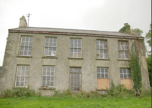
| Greenhills (Raphoe) | William Fenwick held this property in fee at the time of Griffiths Valuation in the 1850s, when it was valued at £55. The National Inventory of Architectural Heritage suggests that it dates from the later eighteenth century though altered in the 1870s. It was originally associated with the Nesbit family into which William Fenwick married. In 1906 it was owned by Philip and Charles Fenwick and valued at £27. The house is still extant though not in good repair. |
|
| Castlefin House | At the time of Griffiths Valuation in the 1850s, Nicholas Simms was leasing this property from Margaret E. Rogan when it was valued at £32. It is labelled Castlefin House on all editions of the Ordnance Survey maps. The site is now occupied by the modern RC church. | |
| Demesne (Raphoe South) | William Baird was leasing this property from the representatives of Connelly M.L. Leckey at the time of Griffith's Valuation in the 1860s, when it was valued at £10. The original building is not extant. | |
| Mullanboy | William Baird was leasing this property from the representatives of Connelly M.L. Leckey at the time of Griffith's Valuation in the 1860s, when it was valued at £30 with a substantial mill complex adjoining. Elements of the mill complex are still extant. | |
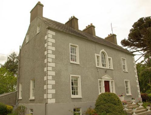
| Guystown (Raphoe) | At the time of Griffiths Valuation in the 1850s, Benjamin Humfrey was leasing this property from the Erne estate, when it was valued at £7. It was subsequently enlarged and is labelled Guystown on all editions of the Ordnance Survey map. The National Inventory of Architectural Heritage suggests it was originally built c.1720. It is still extant and occupied. | |
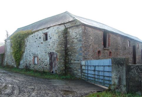
| Toberoneill | At the time of Griffiths Valuation in the 1850s, Joseph Henderson was leasing this property from the Earl of Erne's estate when it was valued at £12. The National Inventory of Architectural Heritage suggests the large scale outbuildings date from c.1860. There is an altered house at the site. |
|
| Shannon Middle | James Henderson was leasing this property from the Earl of Erne's estate at the time of Griffiths Valuation in the 1850s, when it was valued at £11. It is labelled Shannon Middle on all editions of the Ordnance Survey maps. Substantial farm buildings exist at the site now. | |
| Shannon (Raphoe North) | Samuel Gourley was leasing this property from the Erne estate at the time of Griffiths Valuation, when it was valued at £10. It is labelled Shannon on all editions of the Ordnance Survey maps. A farm is extant at the site. | |
| Killindarragh [Nassau Hall] | At the time of Griffiths Valuation, in the 1850s, Mrs. Angel I. Stewart was leasing this property from the Earl of Erne's estate when it was valued at £20. It is labelled Nassau Hall on the 1st edition Ordnance Survey map of the late 1830s but as Killindarragh on subsequent editions. It is still extant. | |
| Beltany | David Wilson was leasing this property from the Ecclesiastical Commissioners estate at the time of Griffiths Valuation in the 1850s, when it was valued at £17. It is now a ruin. | |
| Finn Lodge | Sir Frederick Heygate's estate held this property in fee at the time of Griffiths Valuation in the 1850s, when it was valued at £11. Farm buildings occupy the site now. | |
| Magherycallaghan House | James McCurdy was leasing this property from the Macky estate at the time of Griffiths Valuation in the 1850s when it was valued at £18. A mill complex was located in the area also. The National Inventory of Architectural Heritage suggests the house was built in the late eighteenth century. Later in the nineteenth century it was associated with the Cunningham family. It is still extant and occupied. |
|