Mackan
Houses within 5km of this house
Displaying 12 houses.
Houses within 5km of Mackan
Displaying 12 houses.
| House name | Description | |
|---|---|---|
| Killygar | It is estimated by the National Inventory of Architectural Heritage that Killygar was built in 1813. At the time of Griffith's Valuation Killygar House was occupied by John Godley and was valued at £43. It was also the residence of John Godley in 1814 and in 1837. In 1894 Slater refers to it as the seat of Archibald Godley. It is still extant and occupied by the Godley family. |
|
| Greenville (Cavan) | The Thorntons were located at Greenville from the 18th century. The house was situated east of Greenville Lough and north of Ardlougher. At the time of Griffith’s Valuation the buildings described as a house, steward’s house, offices and lodge were valued at £40 for rates. The property was held by Perrott Thornton in fee. In 1864 the Greenville estate of William Robert Thornton was advertised for sale in the Landed Estates Court including the house and demesne. In 1876 George Nugent, the owner of 400 acres in county Cavan, is recorded as resident at Greenville, Ardlougher. His estate including Greenville was for sale in November 1880 when the house was described as 'handsome, modern, substantially built, in excellent order, well supplied with water, and fit for the immediate reception of a large family'. The home of Lieutenant Colonel William Alexander Crawford Roe and his wife Emma in 1901 and of the Clifford sisters Olivia and Edith in 1911. In 1906, it was described as a 'mansion' with a rateable valuation of £40. The house is no longer in existence. | |
| Carn Cottage | Griffith’s Valuation records Captain Richard Clifford as owner and occupier and the building was valued at £28.15.0. At the beginning of the 20th century this house was the home of [retired] Lieutenant General Robert Cecil Richard Clifford, Indian Staff Corps and his wife and daughter. http://bygonedaysphotography.blogspot.ie/2016/08/two-clifford-sisters.html |
|
| Carn House | Leet records William Benison of Carn, Killeshandra, in 1814 and Lewis refers to J. Benison of Carn in 1837. The first edition six inch Ordnance Survey map (publ. 1837) shows two houses within the demesne at Carn, named Carn House and Carn Cottage. A new house on a new site is named Carn House on the 25 inch map (H296136). By the time of Griffith’s Valuation Moses Netterfield held the property valued at £15.10.0., including a house and herd’s house, from Captain Bedel Stanford. Part of the house appears to be still occupied. | |
| Ballyhugh House | Ballyhugh House is named on the first edition six inch Ordnance Survey map (publ. 1837) within a small demesne. There was no building on the site in the early 20th century. ‘Ballyhue’, Ballyconnell, was occupied by John Feris in 1814. Griffith’s Valuation records the rateable valuation as £10 and John Grimes as resident, holding the property from John E. Vernon. | |
| Bilberry Hill | William Stanford of Bilberry Hill was High Sheriff of county Cavan in 1774. This house was the home of the Irwin family from at least 1790 when Daniel Irwin of Bilberry Hill married a Miss E. Faris of Cloncorick. Leet records David Irwin as resident in 1814 and Jane Elvin [Irwin] was the occupant in the 1850s holding the property valued at £10.10.0. from Thomas Irvine [Irwin]. Jane Irwin died at Bilberry Hill in 1876 (Cavan Weekly News, 28 July 1876). The Irwins were succeeded by the Berrys of Berrymount to whom they were related. This house is no longer extant. | |
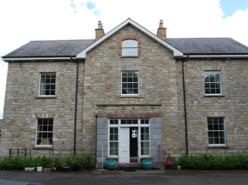
| Aubawn | Described by Mulligan as a ‘medium-size Late Georgian villa’. In 1814 Henry Lenauze was resident at Aubawn, Killeshanadra and Lewis records Aughabawn as the home of the Reverend J. Vernon. The Upton Papers (RIA) contain the will of M. Story of Aubawn, 1817. By the mid-1850s Richard Fox was the owner and occupier of Aubawn, with a rateable valuation of £21. In 1876 the address of George De La Poer Beresford, owner of 570 acres in the county, was Auburn, Killeshandra. Douglas G. Adams occupied the house in 1901, holding it from Beresford while a land steward William Gordon and his family were resident in 1911. This house has been renovated and modernised. |
|
| Croaghan House | A small house named on the first edition six inch Ordnance Survey map (publ. 1837). The building was later extended and in the mid-1850s was occupied by the Reverend Allan, who held it from Richard Carson. It was valued at £11. David Hamill Crawford, land agent, and family were resident in the early 20th century, this building appears to be still extant. | |
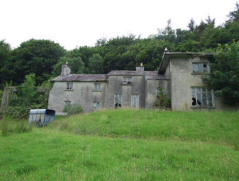
| Drummully House | In the mid-19th century a house valued at £10 was owned and occupied by Catherine Dickson in Drumully East. By the early 20th century a substantial house named Drom Mullac is shown on the 25 inch map when the Lough family were resident. There are references to Albert Hutton of Drummully House, Killashandra in 1876; Mrs Louisa Frances Hickson, widow of William Murray Hickson in 1884 and Thomas Lough MP of Drummully in 1898. This house became a convent and was demolished in 2012. | |
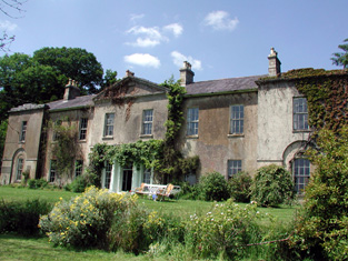
| Castle Hamilton | In the mid-18th century Castle Hamilton came into the possession of the Southwell family through marriage with a Hamilton co-heiress. It remained in Southwell ownership until about the 1840s. Both Leet and Lewis record members of the Southwell family as resident. Lewis describes the house as ‘a spacious mansion surrounded by an extensive and highly embellished demesne’ adjoining the town of Killeshandra. The buildings were valued at £50 in the mid-19th century, by which time James Hamilton was owner and occupier. The Hamiltons were still resident at the time of the censuses of 1901 and 1911. The house was accidentally destroyed by fire in 1911 but a fine farm yard survives. |

|
| Portaliff House | Portaliff House was located on the Castle Hamilton estate, north of Mill Lough and a little south of Killashandra. In the mid-19th century it was occupied by Captain F.H.B. Philips when it was valued at £12 for rates. Portaliff House is listed as a protected structure. | |
| Berrymount | Berrymount House is named on the first edition six inch Ordnance Survey map (publ. 1837). James Berry was resident in the first half of the 19th century. He held the house and outbuildings valued at £7 from the representatives of John C. Jones. William Berry of Berrymount owned 134 acres in co Cavan in 1876. The Berrys were selling Berrymount in the early 1890s (Irish Law Times and Solicitors Journal, Vol 27, 615). Alexander Morton and family were living at Berrymount in the early 20th century. The house appears to be still extant. |