Carrig Hill
Houses within 5km of this house
Displaying 13 houses.
Houses within 5km of Carrig Hill
Displaying 13 houses.
| House name | Description | |
|---|---|---|
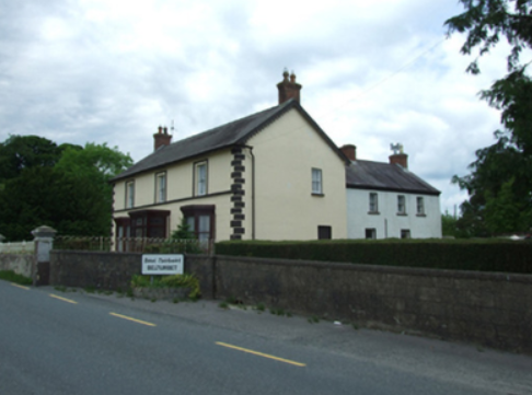
| Erne Hill House | Located on the outskirts of Belturbet, Erne Hill House was the home of George M. Knipe with a rateable valuation of £45, at the time of Griffith’s Valuation. By 1878 John E. Vernon was living at Erne Hill. The Knipe mausoleum is nearby and a gate lodge is extant but the house is demolished. |
|
| Sugarloaf | John Gumley of Sugarloaf died in 1794 (gravestone inscription Belturbet COI). Sugarloaf was located south east of Belturbet. In 1835 Theophilus Brinsley Butler of Dublin leased the house and gardens to Mary Finlay of Sugarloaf house, county Cavan, widow, for the lives of her son Sir Thomas Finlay and her daughter Elizabeth Lake Finlay. By the 1850s Samuel Knipe was resident holding the property from Captain Humphry Butler. It had a rateable valuation of £10.10.0. |
|
| Nixon Lodge/Griffith Lodge | A mid-18th century house, named Nixon Lodge on the first edition 6 inch Ordnance Survey map (publ. 1837). It was the home of the Reverend Andrew Nixon and his wife Marianne French of Frenchpark, county Roscommon, in the 18th century. Their son Humphrey had eight children. Nixon Lodge was later known as Griffith Lodge and Griffith’s Valuation records Dorothea Griffith as the occupant. She held the property in fee and the buildings were valued at £16.10.0. Occupied by the Smith family at the beginning of the 20th century. Somewhat reduced in size this house is still extant and occupied. | |
| Carn Cottage | Griffith’s Valuation records Captain Richard Clifford as owner and occupier and the building was valued at £28.15.0. At the beginning of the 20th century this house was the home of [retired] Lieutenant General Robert Cecil Richard Clifford, Indian Staff Corps and his wife and daughter. http://bygonedaysphotography.blogspot.ie/2016/08/two-clifford-sisters.html |
|
| Carn House | Leet records William Benison of Carn, Killeshandra, in 1814 and Lewis refers to J. Benison of Carn in 1837. The first edition six inch Ordnance Survey map (publ. 1837) shows two houses within the demesne at Carn, named Carn House and Carn Cottage. A new house on a new site is named Carn House on the 25 inch map (H296136). By the time of Griffith’s Valuation Moses Netterfield held the property valued at £15.10.0., including a house and herd’s house, from Captain Bedel Stanford. Part of the house appears to be still occupied. | |
| Ardue House | Ardue House was the home of the Clemengers, a family of German origin, throughout the 19th century. Mr Clemenger was resident in 1814 and Alexander Clemenger in the 1850s when the house was valued at £13 and held from James H. Story. Henry Taunt Clemenger and his unmarried son John James were resident in 1911. The house was located between Killywilly Lough and Tomkinroad Lough. The site is now a green field. | |
| Ashgrove | The National Inventory of Architectural Heritage refers to this house as ‘a classic Palladian composition’ dating from the mid-18th century. Ashgrove was occupied by John Baker in 1814 who probably gave his name to the nearby Bakers Bridge. By the mid-19th century it was the home of Robert Battersby who held the property in fee. The buildings had a rateable valuation of £20. Ashgrove was the home of Miss Mary Jane Sheridan in 1901 and in 1911. In 1906, it was described as a mansion house with a rateable valuation of £23.10.0. It continues to be a residence. | |
| Ballyhugh House | Ballyhugh House is named on the first edition six inch Ordnance Survey map (publ. 1837) within a small demesne. There was no building on the site in the early 20th century. ‘Ballyhue’, Ballyconnell, was occupied by John Feris in 1814. Griffith’s Valuation records the rateable valuation as £10 and John Grimes as resident, holding the property from John E. Vernon. | |
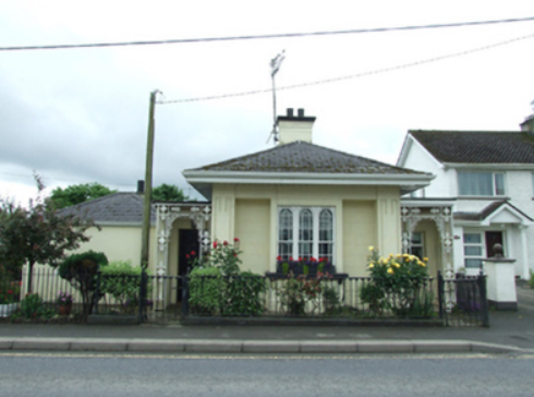
| Killicar House | Named on the first edition six inch Ordnance Survey map (publ. 1837) and situated in a small demesne in which was situated a quarry. In 1814 Mr William Gwynne was recorded as the proprietor of Killicar, Belturbet by Ambrose Leet. Slater’s Directory of 1846 records Arthur Nesbitt as resident at Killicar Lodge, Belturbet. Killicar House appears to have been extended by the time of Griffith’s Valuation, when it was valued at £18 for rates. John A. Nesbitt was the owner and occupier. In 1906, Anne Davey was described as the occupier of this 'mansion' house with a rateable valuation of £21. There are also references to John Albert Nesbitt of Fort Hill, Drumasladdy [a townland adjoining Killicar] and this house may have been known as Fort Hill for a time. A building is still extant at this site. | |
| Killywilly House | Killywilly House located between Loughs Killywilly and Cuillaghan is named on the first edition six inch Ordnance Survey map (publ. 1837). A corn mill and bleach mill were nearby in the townland of Ardue. James Berry was the occupier in the 1850s. He held the property from James H. Story and the buildings had a rateable valuation of £18. There is still an extant house at the site. | |
| Oatlands | Built in the 1840s or 1850s and located on the side of the road, Oatlands was the residence of William Rogers at the time of Griffith’s Valuation. He held the property in fee and its rateable valuation was £11. In 1901 Margaret Rogers, a widow, lived at Oatlands with her daughter’s family, the Gaffneys. in 1906, Margaret J. Gaffney was recorded as the occupier, when the building had a rateable valuation of £14. Home of the O’Reilly family in 1911and still extant. | |
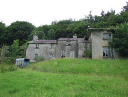
| Glenview (Drumlane) | Glenview House was built in the 1840s or 1850s. Captain Michael Phillips owned and occupied it and it had a rateable valuation of £11.10.0. Home of the Ebbitt family at the beginning of the 20th century but no longer extant. | |
| Ture Lodge | Ture Lodge, facing east onto Clonamullig Lough, was the home of John Mont. Jones in 1814. Cavan newspapers refer to David Griffith as the occupier in 1847 and Joseph Knight in 1850. The house was vacant when surveyed for Griffith’s Valuation. Myles Reilly was the immediate lessor holding from James H. Story. The buildings were valued at £18. In 1876 Mrs Sarah Story owned 814 acres in county Cavan, while James Story of the same address owned 405 acres. This house was marked ‘in ruins’ on the 25 inch map of the early 20th century. |