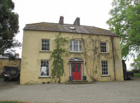
Coolnacarte
Houses within 5km of this house
Displaying 13 houses.
Houses within 5km of Coolnacarte
Displaying 13 houses.
| House name | Description | |
|---|---|---|
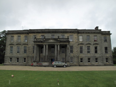
| Hilton Park | According to Shirley it was originally called Maddenstown, changed circa 1780 to Hilltown or Hilton. The Reverend Samuel Madden purchased the estate in 1734 and built the house. It was badly burnt in 1803. In Griffith’s Valuation the buildings were valued at £110 and held by John Madden in fee. The house was extensively enlarged in the 1870s for John Madden by William Hague. The gardens were designed by Ninian Niven. Hilton Park is still the family home of the Madden family where they offer luxury accommodation and authentic country house food, see http://www.hiltonpark.ie/ |
|
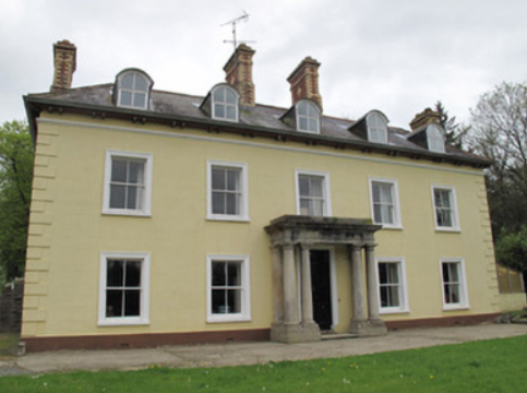
| Lakeview/Clonoony House | On the Griffith’s Valuation map Lakeview House is the same building as that named Clonoony House on the 25 inch map (surveyed 1908). Lakeview was occupied by David Smyth from at least the 1830s and held by him in fee. The buildings were valued at £20. It was the home of the Garland family in the early 20th century. A roof extension and portico have recently been added to this house. | |
| Mount Salem | Mount Salem situated on the Barrett-Lennard estate was marked on the 1st edition 6 inch Ordnance Survey map (1836) and on the later 25 inch map. It was located close to the border with county Fermanagh, just west of the town of Clones. The Reverend Adam Averell, a Methodist minister, died at Mount Salem on 10 January 1847, aged 93. Griffith’s Valuation records Amelia J. Conts as the occupant, holding the property from James Gregg. The buildings were valued at £13. In the early 20th century the McKenna family were resident but the house is now demolished. | |
| Ferney Hill | A house at this site was valued at £10, located on the Barrett-Lennard estate and held by Mary Jameson at the time of Griffith’s Valuation. The National Inventory of Architectural Heritage dates the present house circa 1890. Mulligan writes that it was built for a town merchant Mr M. Maguire. |
|
| Cloncurrin House | This house was not built at the time of the 1st edition 6 inch Ordnance Survey map published in 1836. At the time of Griffith’s Valuation in the 1850s it was occupied by Francis Fitzgerald who held the property from Sir Thomas Barrett-Lennard, when it was valued at £25. Occupied by John A. Moore in 1901 and still in use as a residence. |
|
| Munnilly House | This house is marked on both the first edition 6 inch Ordnance Survey map and the 25 inch map but the building no longer exists. It was the home of the Shegog family. It was situated on the Barrett-Lennard estate and in the mid-19th century was valued at £14 and occupied by William Shegog, born 1824. He was the eldest son of George Shegog, a Justice of the Peace and paymaster of the Fermanagh Militia and Margaret Hamilton. George was the son of John Shegog of Mount Carmel and the family came to Ireland in 1760 from Lubec, Lower Saxony. | |
| Teehill Cottage | The National Inventory of Architectural Heritage dates this house circa 1820. It was built on the Barrett-Lennard estate before the nearby Ulster Canal was constructed. Valued at £10 at the time of Griffith’s Valuation it was occupied by Henry Brown who held it from Thomas Robinson. Home of Edward Scott at the beginning of the 20th century. |
|
| Cloncallick | Built close to Munnilly Lough on the Barrett Lennard estate post Griffith’s Valuation as the building at this site at the time was only valued at £8. It was occupied by Joseph Moorhead. This house has out buildings with a date stone of 1865 and there is a gate lodge at the entrance gate. The Moorehead family were still resident in 1901 and 1911. |
|
| Scarvy House | Scarvy was the home of Major Campbell Graham in the 1830s. About this time the original house, which is marked on the 1st edition 6 inch Ordnance Survey Map (1836), was replaced by a new one. The Ordnance Survey Field Name Book records ‘Near the centre of the townland there is a good house with large orchards, gardens etc belonging to the proprietor but it is going to be replaced by a larger one near the same spot which is now building.’ By about 1860 the buildings were valued at £38 and held by Lydia Campbell from Thomas de Burgh. Occupied by the Duggan farming family in 1901. Not occupied in 1911 but still held by Colonel de Burgh. |
|
| Lisabuck | The Ordnance Survey Field Name Book records that ‘The residence of the Sloans stands near the N. side of the townland, it has been formerly a fine house but it was destroyed by fire about 30 years ago and was never properly rebuilt, it has a very large orchard and garden and is occupied by one of Mr Wright’s tenants.’ The 1st edition 6 inch Ordnance Survey Map (1836) shows some buildings and a large garden located near the shore of Lisabuck Lake. By the time of Griffith’s Valuation Henry Jackson held this townland in fee and the building valued at £3.10.0. was described as a herd’s house. A building is still located on this site. | |
| Clinkeehan | Clinkeehan House is marked on the 25 inch Ordnance Survey Map (surveyed 1908). A house in this townland was valued at £10 in the mid-19th century and was occupied by Robert Armstrong who held it from Robert L. Ellis. Members of the Armstrong family were resident in the early 20th century. This house is extant. | |
| Green Cottage | This house is marked on the 1st edition 6 inch Ordnance Survey Map (1836) and on the 25 inch map (surveyed in 1908), it is named Green Cottage. It was the home of the owner of the nearby mill, James Knight in the late 1850s who held it in fee. The buildings were valued at £14. In 1876, Luke Knight owned 118 acres in county Monaghan. Members of the Knight family continue to reside there in the first decades of the 20th century. Corcummins borders the Hilton Demesne. | |
| Redhill House | The Whyte family were resident at Redhill from the 17th century. The first edition Ordnance Survey map (publ. 1837) marks a building in ruins which was the original castle. A house was built to the north east. The Ordnance Survey Field Name Book states that Redhill lately belonged 'to Mr White now in France, estate in Chancery, executors Mr Boyd of Cootehill and Col Clements'. The house 'is a small tho' convenient building with out-houses, the ancient castle in ruins, destroyed by fire 40 years ago.....The house is unoccupied except by a care taker’. Following the death of Francis Melville Whyte in 1833, Redhills was inherited by his niece Georgina Mary Enderby. She married the Reverend Edmund Burke Venables in 1847. Named on the first edition Ordnance Survey map (publ. 1837), Redhills was the residence of the Reverend E.B.W. Venables at the time of Griffith’s Valuation. Valued at £8, he held it in fee. Redhills was the home of the Reverend Arthur Thellusson Oddie in 1905 when he assumed the name and arms of Whyte Venables. In 1906, Georgina Whyte Venables is recorded as occupant when the mansion house was valued at £53.10.0. A building still stands on this site and the gate lodge survives. |
|