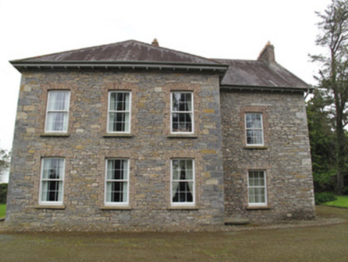
Dromore House
Houses within 5km of this house
Displaying 14 houses.
Houses within 5km of Dromore House
Displaying 14 houses.
| House name | Description | |
|---|---|---|
| Bessmount Park | The original house ‘Bessmont’, sometimes spelt Bessmount, dates from the early 1800s and is marked and named on the 1st edition 6 inch Ordnance Survey map (1836) with a walled garden to the south. It was the home of a branch of the Montgomery family and was inherited through marriage by the Nixons. In the 1830s it was the residence of A. Nixon Montgomery. In 1840 it was acquired by John Hatchell, High Sheriff of Monaghan in 1843 and his daughter held the house in fee circa 1860. The buildings were valued at £46. The house was elaborately re-modelled in an ornate style possibly to the design of an unknown architect in the late 1860s for the owner William Henderson and became known as Bessmount Park. William Henderson was married to John Hatchell’s daughter Frances Maria Isabella. Mrs Henderson, described as a widow, was living in the house in 1901 and a retired doctor Edward Taylor in 1911. This house continues to be a fine residence. |

|
| Beech Hill | Located on the outskirts of Monaghan town, Beech Hill is named on the 1st edition 6 inch Ordnance Survey Map (1836). The buildings at Beech Hill were valued at £40 in the mid-19th century. William Murray was the occupant. He held the property from Lord Rossmore. Sarah Ker, eldest daughter of André Allen Ker, is described in Burke’s Landed Gentry of Ireland (1904) as resident here. In 1880 she married Fitzjohn Robert Irwin of Kilkeel, county Down. Beech Hill College, a secondary school, is now located on this site. | |
| Castleshane | Castleshane was the home of the Lucas family from the mid-17th century. The original house was described by Lewis as ‘an ancient mansion in a highly enriched and tastefully embellished demesne’. In 1836 it was replaced by a Elizabethan or Jacobean style house built for the Right Honourable Edward Lucas. It was valued at £160 in the mid-19th century and in 1906 when surrounded by 359 acres of untenanted land. Occupied by the Honourable Kathleen Vereker in 1901 and by servants in 1911, this house was burnt on 15 February 1920. Tarquin Blake has documented the remains in his second volume of Abandoned Houses. | |
| Liscarney House | The home of the Ross family for at least a century and a half. David Ross of Liscarney is mentioned in a deed of 1816. Major Ross is recorded in Liscarney in the Tithe Applotment Book and also by Lewis in the 1830s. In Griffith’s Valuation (circa 1860) James Ross (1819-1893) is mentioned as the occupier holding the property in fee. The buildings were valued at £32. Members of the Ross family continued to reside here well into the 20th century as The Irish Law Times and Solicitors Journal of 1955 records the death of Sharman Crawford Ross, solicitor and estate agent, of Liscarney. |
|
| Faulkland Castle | Shirley refers to the confinement of John Leslie, Dean of Dromore, by Robert Maxwell, Sheriff of Monaghan, in his house at Falkland/Faulkland in 1707. The Maxwells occupied Faulkland Castle until 1780. By the time of Griffith’s Valuation it was valued at £1.6 shillings and was held by James Jackson Senior from the trustees of John Maxwell. The 25 inch map (surveyed 1908) shows the castle ‘in ruins’. | |
| Coolmain House | The National Inventory of Architectural Heritage dates this house to circa 1790. It belonged to a family called Graham in the 18th century according to a story recorded in the Schools Collection under Coolmain House. It was named on the 1st edition 6 inch Ordnance Survey Map (1836). In the 19th century this property belonged to the Brooke family of Dromavana, county Cavan. Burke’s Landed Gentry of Ireland 1904 records William Brooke of Dromavana, Dublin and Coolmaine House. He was born in 1769 and married Angel daughter of Captain Edward Perry and niece and heiress of Colonel Richard Graham. John Goudy of Coolmain House is listed in Lewis’ ‘Topographical Dictionary’ published 1837 for the parish of Tehallan but his name is spelt Gondy in the list of subscribers. John Goudy is recorded in Griffith’s Valuation as resident holding the property from the Reverend Edward P. Brooke and others. James Gondy Lewers of Coolmain House died in November 1885 (The Northern Standard, 7 November 1885). This house was occupied by James H. Pollock in 1911 and is still a residence. | |
| Greenmount | Marked on the 1st edition 6 inch Ordnance Survey map (1836) this house was described as a thatched 2 storey house with an orchard and nursery. The grounds were planted all-round the house. It was extended after Griffith’s Valuation and was the home of the agents for the Castleshane estate. At the beginning of the 20th century it was occupied by William Martin, land agent. In the 1920s Martin purchased Greenmount and following the death of his sister in 1949 it was sold to Albert Noble. |
|
| Annareagh House | Built in the mid-19th century, valued at £16 and held by William Martin from the trustees of Dr Sterne Charities. Named on the 25 inch map (surveyed 1908) as Annarea House with a square block of outbuildings behind the house. | |
| Sallymount | Sallymount facing a plantation is named on the 1st edition 6 inch Ordnance Survey map (1836). In the 1830s it was the home of T. Robinson. At the time of Griffith’s Valuation the buildings were valued at £8 and John Woods was the occupant, holding the property from John Maxwell, whose estate was at that time being administered by the Court of Chancery. Home of the Assistant County Surveyor James Smith in 1911. He held the house from John McMahon. A building is still located at this site. | |
| Will Ville | The National Inventory of Architectural Heritage dates this building early 18th century. It was located on the estate of Lord Rossmore and is named on the 1st edition 6 inch Ordnance Survey map (1836). Valued at £10 and occupied by Robert Wilson at the time of Griffith’s Valuation. Still occupied by Robert Wilson, farmer, in the early 20th century. This house has been unoccupied for some time. |
|
| Tirkeenan House | This house is named on the 1st edition 6 inch Ordnance Survey map (1836). It was located on the Rossmore estate and very close to the town of Monaghan. It was occupied by John M’Dowell circa 1860 when the buildings were valued at £32. A third storey was added to this house in the 20th century. |

|
| Corlat House | A house named Cook Mount was located in Corlat on the first Ordnance Survey Map (circa 1836). Corlat House was built in the mid-19th century on a nearby site, valued at £20 and occupied by the Reverend James Bleakley, who held it from William Murray. In the early 20th century William McWilliam, Clerk of the Crown and Peace lived at Corlat House. It is no longer extant. | |
| Harry Mount | The Ordnance Survey Field Name Book describes this house as a small, thatched, one storey farm house, with a garden and orchard. The house was on the Lucas estate and is named on the 1st edition 6 inch Ordnance Survey map (1836). The buildings at Harry Mount, which included a flax mill, were valued at £12.10 shillings in Griffith’s Valuation when the house was occupied by Charles Carson. The Carson family were still resident at the beginning of the 20th century. McSkane writes that this was a thatched building which remained thatched up to the 1950s. Built for Henry Swanzy circa 1816 and sold to James Carson from Ballybay in 1839. | |
| Woodview | Situated on the Lucas estate, this house was not built at the time of Griffith’s Valuation (circa 1860) as there is no house in the townland of more than £2.10.0. valuation. The National Inventory of Architectural Heritage records that it is believed to have been built as a house for the agent to the Castleshane estate. |