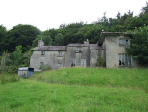
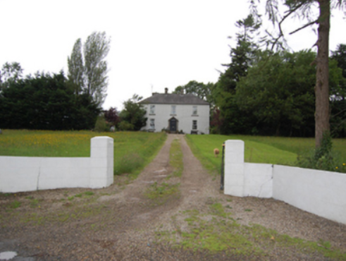
Nixon Lodge/Griffith Lodge
Houses within 5km of this house
Displaying 12 houses.
Houses within 5km of Nixon Lodge/Griffith Lodge
Displaying 12 houses.
| House name | Description | |
|---|---|---|
| Greenville (Cavan) | The Thorntons were located at Greenville from the 18th century. The house was situated east of Greenville Lough and north of Ardlougher. At the time of Griffith’s Valuation the buildings described as a house, steward’s house, offices and lodge were valued at £40 for rates. The property was held by Perrott Thornton in fee. In 1864 the Greenville estate of William Robert Thornton was advertised for sale in the Landed Estates Court including the house and demesne. In 1876 George Nugent, the owner of 400 acres in county Cavan, is recorded as resident at Greenville, Ardlougher. His estate including Greenville was for sale in November 1880 when the house was described as 'handsome, modern, substantially built, in excellent order, well supplied with water, and fit for the immediate reception of a large family'. The home of Lieutenant Colonel William Alexander Crawford Roe and his wife Emma in 1901 and of the Clifford sisters Olivia and Edith in 1911. In 1906, it was described as a 'mansion' with a rateable valuation of £40. The house is no longer in existence. | |
| Carn Cottage | Griffith’s Valuation records Captain Richard Clifford as owner and occupier and the building was valued at £28.15.0. At the beginning of the 20th century this house was the home of [retired] Lieutenant General Robert Cecil Richard Clifford, Indian Staff Corps and his wife and daughter. http://bygonedaysphotography.blogspot.ie/2016/08/two-clifford-sisters.html |
|
| Carn House | Leet records William Benison of Carn, Killeshandra, in 1814 and Lewis refers to J. Benison of Carn in 1837. The first edition six inch Ordnance Survey map (publ. 1837) shows two houses within the demesne at Carn, named Carn House and Carn Cottage. A new house on a new site is named Carn House on the 25 inch map (H296136). By the time of Griffith’s Valuation Moses Netterfield held the property valued at £15.10.0., including a house and herd’s house, from Captain Bedel Stanford. Part of the house appears to be still occupied. | |
| Ashgrove | The National Inventory of Architectural Heritage refers to this house as ‘a classic Palladian composition’ dating from the mid-18th century. Ashgrove was occupied by John Baker in 1814 who probably gave his name to the nearby Bakers Bridge. By the mid-19th century it was the home of Robert Battersby who held the property in fee. The buildings had a rateable valuation of £20. Ashgrove was the home of Miss Mary Jane Sheridan in 1901 and in 1911. In 1906, it was described as a mansion house with a rateable valuation of £23.10.0. It continues to be a residence. | |
| Ballyhugh House | Ballyhugh House is named on the first edition six inch Ordnance Survey map (publ. 1837) within a small demesne. There was no building on the site in the early 20th century. ‘Ballyhue’, Ballyconnell, was occupied by John Feris in 1814. Griffith’s Valuation records the rateable valuation as £10 and John Grimes as resident, holding the property from John E. Vernon. | |
| Carrig Hill | Carrig Hill is named on the first edition six inch Ordnance Survey map (publ. 1837). In the 1850s it was occupied by John Berry who held the property from Maria Finlay. In 1876 Alfred Morton of Carrigan, Ardlogher, was the owner of 50 acres. Carrig Hill was a Gilsenan home in the early 20th century and is still occupied. | |
| Lake View House (Drumlane) | Home of Richard J. ‘Hynes’ (Hinds) at the time of Griffith’s Valuation, Lake View House was held in fee and had a rateable valuation of £10. It was built after the first Ordnance Survey of the 1830s and before the primary valuation survey. Henry Hinds in 1901 and Mrs Charlotte E. Hinds in 1911 held a vacant house in Deramfield. Lake View House is presently occupied. |
|
| Killicar House | Named on the first edition six inch Ordnance Survey map (publ. 1837) and situated in a small demesne in which was situated a quarry. In 1814 Mr William Gwynne was recorded as the proprietor of Killicar, Belturbet by Ambrose Leet. Slater’s Directory of 1846 records Arthur Nesbitt as resident at Killicar Lodge, Belturbet. Killicar House appears to have been extended by the time of Griffith’s Valuation, when it was valued at £18 for rates. John A. Nesbitt was the owner and occupier. In 1906, Anne Davey was described as the occupier of this 'mansion' house with a rateable valuation of £21. There are also references to John Albert Nesbitt of Fort Hill, Drumasladdy [a townland adjoining Killicar] and this house may have been known as Fort Hill for a time. A building is still extant at this site. | |
| Oatlands | Built in the 1840s or 1850s and located on the side of the road, Oatlands was the residence of William Rogers at the time of Griffith’s Valuation. He held the property in fee and its rateable valuation was £11. In 1901 Margaret Rogers, a widow, lived at Oatlands with her daughter’s family, the Gaffneys. in 1906, Margaret J. Gaffney was recorded as the occupier, when the building had a rateable valuation of £14. Home of the O’Reilly family in 1911and still extant. | |
| Ture Lodge | Ture Lodge, facing east onto Clonamullig Lough, was the home of John Mont. Jones in 1814. Cavan newspapers refer to David Griffith as the occupier in 1847 and Joseph Knight in 1850. The house was vacant when surveyed for Griffith’s Valuation. Myles Reilly was the immediate lessor holding from James H. Story. The buildings were valued at £18. In 1876 Mrs Sarah Story owned 814 acres in county Cavan, while James Story of the same address owned 405 acres. This house was marked ‘in ruins’ on the 25 inch map of the early 20th century. | |
| Croaghan House | A small house named on the first edition six inch Ordnance Survey map (publ. 1837). The building was later extended and in the mid-1850s was occupied by the Reverend Allan, who held it from Richard Carson. It was valued at £11. David Hamill Crawford, land agent, and family were resident in the early 20th century, this building appears to be still extant. | |
| Drummully House | In the mid-19th century a house valued at £10 was owned and occupied by Catherine Dickson in Drumully East. By the early 20th century a substantial house named Drom Mullac is shown on the 25 inch map when the Lough family were resident. There are references to Albert Hutton of Drummully House, Killashandra in 1876; Mrs Louisa Frances Hickson, widow of William Murray Hickson in 1884 and Thomas Lough MP of Drummully in 1898. This house became a convent and was demolished in 2012. |