Drummond Cottage
Houses within 5km of this house
Displaying 8 houses.
Houses within 5km of Drummond Cottage
Displaying 8 houses.
| House name | Description | |
|---|---|---|
| Derrylavan | A small building was located at this site on the 1st edition 6 inch Ordnance Survey Map (1836). The buildings were valued at £16 circa 1860 when William Lane was resident. He held 218 acres, about half the townland from Evelyn P. Shirley. Lough Fea was nearby. There was a milling complex a short distance away in the same townland. This house appears to be still extant. | |
| Losset House | This house was built in the mid-19th century on the Shirley estate, close to Lough Fea Castle. It was valued at £8 and occupied by William Roarke. |

|
| Lough Fea House | Built in 1827 to the design of Thomas Rickman, this large house was the first residence of the Shirleys in county Monaghan, although they had owned a large estate since Elizabethan times. Lewis described this new edifice as ‘a spacious and handsome structure in the Elizabethan style of architecture’. A church and great hall were later additions. The buildings were valued at £180 circa 1860. The Shirley family continue to live at Lough Fea. | |
| Doohatty | A building named Cottage is marked on the first edition Ordnance Survey map (1836). It was located in the same townland as Lough Fea House, the home of the Shirley family. In the mid-19th century John Cooper was the occupant and the building was valued at £12. It appears to still be extant. | |
| Cabra Cottage | This house was the home of the Pratt family until Cormey Castle was purchased in 1813 and was renamed Cabra Castle. Cabra Cottage is shown on the first edition six inch Ordnance Survey map (publ. 1837) as a substantial building close to a mill race, quarry and the ruins of the first Cabra Castle. Bence Jones describes this building as an early 18th century villa possibly designed by Sir Edward Lovett Pearce. He writes that it was used as a ballroom following the Pratts move to live in their new home in Cormey. In the mid-19th century it was valued at £20 for rates and Colonel Joseph Pratt was the owner and occupier. The 25 inch map shows the building much reduced in size. Bence Jones writes that it was destroyed by fire in the 1950s. | |
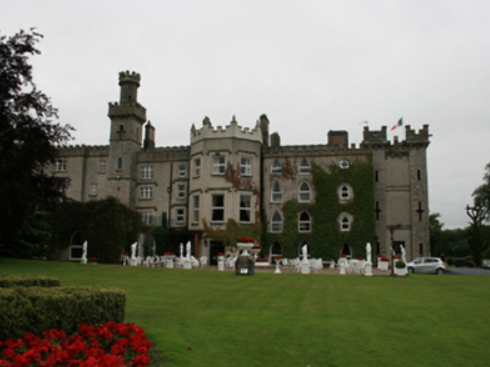
| Cabra Castle | The second Cabra Castle, probably incorporating the old Cormey Castle, was complete by the late 1830s. It is located on the county border between Cavan and Meath. A castellated building of Gothic appearance Cabra Castle had a rateable valuation of £70 in the mid-19th century when occupied and owned by Colonel Pratt. It continued to be the main residence of the Pratts until the mid -0th century when it was inherited by a relative, Mervyn Sheppard, who sold it in the mid-1960s. It now functions as a hotel. https://www.cabracastle.com/ |
|
| Corrinshigo House | Corrinshigo House was located to the west of the other two Pratt homes, Cabra Cottage and Castle. It is named on the first edition six inch Ordnance Survey map (publ. 1837). Lewis records it as the residence of J. Pratt and Griffith’s Valuation records Francis Pratt as the occupier holding the property from Frances E. Pratt. It had a rateable valuation of £15. Occupied by George Pratt and his mother in 1901. Now a green field site. | |
| Mullantra | Mullantra was located on the border between counties Cavan and Monaghan and north of the other Pratt homes in the locality. In 1814 it was occupied by James Butler Pratt. Lieutenant Edward Pratt of Mullantra, Kingscourt, petitioned the Lord Lieutenant in 1822 for an appointment to a post in the police establishment (National Archives CSO/RP/1822/1006). By the time of Griffith’s Valuation this building, the property of Colonel Pratt, had a rateable valuation of £2 and was vacant. A new building appears on a nearby site on the 25 inch map and is still extant in the middle of a forestry area. |