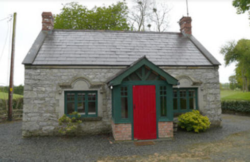
Lisanisk
Houses within 5km of this house
Displaying 16 houses.
Houses within 5km of Lisanisk
Displaying 16 houses.
| House name | Description | |
|---|---|---|
| Rahans | On the 1st edition 6 inch Ordnance Survey map (1836) Rahans is marked with a courtyard and pump at the back of the house. John Read or Reed was the occupant at this time and was still resident at the time of Griffith’s Valuation when the buildings were valued at £32. By the early 20th century Rahans was the home of Dr Peter McKenna. It is no longer extant. | |
| Cormoy House | There was a building located here and marked on the 1st edition 6 inch Ordnance Survey map (1836). Griffith’s Valuation records the house as located on the estate of the Marquess of Bath, valued at £28 and occupied by Peter McCaul. In 1901 it was the only house in the townland and Kate McCaul, a widow, was the head of the household. A building is still located at this site. | |
| Longfield House | Longfield House on the Marquess of Bath’s estate is marked on the 1st edition 6 inch Ordnance Survey map (1836). It was occupied at the time by the Johnston family. The Ordnance Survey Field Name Book describes the residence of W. Johnston as in the west of the townland. By the time of Griffith’s Valuation circa 1860 Thomas Johnston was resident and the buildings were valued at £30. Sidney Jackson and family were living in Longfield House at the beginning of the 20th century. This house no longer exists. | |
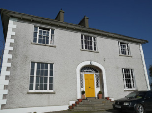
| Donaghmoyne | Donaghmoyne House is named on the 1st edition 6 inch Ordnance Survey map (1836) and the grounds include a walled garden and plantations. A mill and quarry were located nearby. Lewis records Donaghmoyne as the residence of J. Bashford. John Dixie, who had oil and flax mills near the house, was the occupier in the mid-19th century. He held the property, described as a steward’s house, from the Reverend Robin L. Tottenham, whose estate was at that time in the Court of Chancery. The buildings which included a gate lodge were valued at £17. Donaghmoyne was purchased by Richard Bolton from the Reverend Tottenham in the early 1860s. John Marshall Bolton and his wife were resident in the early 20th century. This house is still a residence. |
|
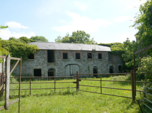
| Capragh | A house located close to Capragh Lough was in existence at the time of the first Ordnance Survey in the 1830s. By the mid-19th century it was occupied by Hubert Kiernan who held the townland in fee. The buildings were valued at £15. Occupied by the Mitchell sisters in 1901 and by Mary Mitchell in 1911. Part of the yard buildings still remain at this site. |
|
| Ballymackney | Ballymackney House is named on the 1st edition 6 inch Ordnance Survey Map (1836) which shows a large walled garden close by. Ballymackney was located on the estate of the Marquess of Bath. Lewis records the proprietor as W. Daniel. It became the home of George Henry Gartlan and his wife Mary McMullan of Cabra, county Down, who married in 1846. Seven years later they left Ballymackney to live at Cabra. At the time of Griffith’s Valuation circa 1860 the house was occupied by David Grimstone who held it from Thomas Jackson. The buildings were valued at £20. This house is still the centre of a farming enterprise just outside the village of Ballymackney. |
|
| Monalty House | This house, located on the Marquess of Bath’s estate, dates from the 18th century and was the residence of the agent, Norman Steele, in 1798. In the 19th century Monalty House was the home of the Gartlan family. It was purchased by James Gartlan, a wealthy distiller in the town of Carrickmacross. Lewis records his son Thomas McEvoy Gartlan as the proprietor in the 1830s. The house is named on the 1st edition 6 inch Ordnance Survey Map (1836). Thomas M. Gartlan was recorded as the occupier in Griffith’s Valuation when the buildings were valued at £26. Members of the Gartlan family were still resident in the early 20th century. https://pdeanisland.wordpress.com/places/carrickmacross/monalty-house/ | |
| Derrylavan | A small building was located at this site on the 1st edition 6 inch Ordnance Survey Map (1836). The buildings were valued at £16 circa 1860 when William Lane was resident. He held 218 acres, about half the townland from Evelyn P. Shirley. Lough Fea was nearby. There was a milling complex a short distance away in the same townland. This house appears to be still extant. | |
| Belle Vue | This house is named on the 25 inch Ordnance Survey map (survey of 1908). It was built on the Shirley estate in the mid-19th century when it was occupied by John Thomas Holland and valued at £16. John Holland was appointed a magistrate by Lord Rossmore in 1854 (Dublin Evening Mail, 11 Oct 1854). Home of the Withrington in the early 20th century, now demolished. | |
| Shirley House | Shirley House located in the town of Carrickmacross is named on the 1st edition 6 inch Ordnance Survey Map (1836). It was the home of the agent, George Morant junior, in the 1840s and 1850s and was occupied by Shirley family members and others at various times, for example Alexander Mitchell in 1837 (Lewis, I, xlvii), Horatio Shirley of Shirley House was High Sheriff in 1872, John Thomas Holland of Shirley House died on 14 October 1881 aged 74 (The Belfast Morning News, 18 Oct 1881), Captain Evelyn Shirley was resident in 1914 and Felix Patrick Smith in 1925 (Thom’s Directory 1926). This house is now demolished. | |
| Tullyallen House | Situated very close to Tullyallen Lough on the Brownlow estate, the buildings at Tullyallen House were valued at £17 in the mid-19th century. The occupant was Anne Kelly. James Murphy, farmer and Justice of the Peace, was resident in the early 20th century. | |
| Drumboory | Located close to a small lough a house valued at £10 was occupied by John Kenny and held from William Brownlow in the mid-19th century. A Kenny family was still located in this townland in the early 20th century. | |
| Losset House | This house was built in the mid-19th century on the Shirley estate, close to Lough Fea Castle. It was valued at £8 and occupied by William Roarke. |

|
| Lough Fea House | Built in 1827 to the design of Thomas Rickman, this large house was the first residence of the Shirleys in county Monaghan, although they had owned a large estate since Elizabethan times. Lewis described this new edifice as ‘a spacious and handsome structure in the Elizabethan style of architecture’. A church and great hall were later additions. The buildings were valued at £180 circa 1860. The Shirley family continue to live at Lough Fea. | |
| Doohatty | A building named Cottage is marked on the first edition Ordnance Survey map (1836). It was located in the same townland as Lough Fea House, the home of the Shirley family. In the mid-19th century John Cooper was the occupant and the building was valued at £12. It appears to still be extant. | |
| Inver Lodge | Henry Edward Porter held a house in fee, valued at £14, in Magheross on the outskirts of Carrickmacross, circa 1860. This appears to be Inver Lodge which is named on the first edition Ordnance Survey map (publ. 1836). This house is still extant. |