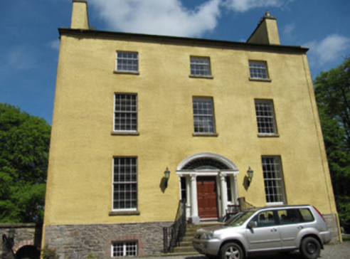
Laragh (Aghnamullen)
Houses within 10km of this house
Displaying 30 houses.
Houses within 10km of Laragh (Aghnamullen)
Displaying 30 houses.
| House name | Description | |
|---|---|---|
| Rahans | On the 1st edition 6 inch Ordnance Survey map (1836) Rahans is marked with a courtyard and pump at the back of the house. John Read or Reed was the occupant at this time and was still resident at the time of Griffith’s Valuation when the buildings were valued at £32. By the early 20th century Rahans was the home of Dr Peter McKenna. It is no longer extant. | |
| Cormoy House | There was a building located here and marked on the 1st edition 6 inch Ordnance Survey map (1836). Griffith’s Valuation records the house as located on the estate of the Marquess of Bath, valued at £28 and occupied by Peter McCaul. In 1901 it was the only house in the townland and Kate McCaul, a widow, was the head of the household. A building is still located at this site. | |
| Longfield House | Longfield House on the Marquess of Bath’s estate is marked on the 1st edition 6 inch Ordnance Survey map (1836). It was occupied at the time by the Johnston family. The Ordnance Survey Field Name Book describes the residence of W. Johnston as in the west of the townland. By the time of Griffith’s Valuation circa 1860 Thomas Johnston was resident and the buildings were valued at £30. Sidney Jackson and family were living in Longfield House at the beginning of the 20th century. This house no longer exists. | |
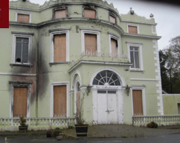
| Blayney/Hope Castle | Originally known as Blayney Castle, this building was a late 18th century three storey five bay Georgian block in the town of Castleblayney. Lewis described it in the 1830s as ‘a handsome modern edifice, built near the site of the old castle’. It was the home of the Lords Blaney until sold in 1853 by the 12th and last Baron. Bought by Henry T. Hope and in his possession and that of his daughter’s descendants the Clintons until 1916 when it was sold. Since then the building has been a military barracks, a hospital in the 1930s and then a convent until the 1970s. In more recent times it was run as a hotel until badly damaged in an arson attack in 2010, since then it has been unoccupied. Owned by Monaghan County Council since the 1980s. |
|
| Drumcrew House | Drumcrew House located near a small lake of the same name and close to the town of Castleblayney. Valued at £10 at the time of Griffith’s Valuation, occupied by Henry Hunter and held from Henry T. Hope. Buildings are still located at this site. | |
| Castleblayney House | This house on the outskirts of Castleblayney, sometimes known as Connaberry House, is marked on the 1st edition 6 inch Ordnance Survey map (1836). Located on the Hope estate it was occupied in the mid-19th century by Hugh Swanzy. The buildings were valued at £25. This house continues to be a residence. | |
| Church Hill | This house with a view to Muckno Lake is marked on the 1st edition 6 inch Ordnance Survey Map (1836). It had quite extensive gardens and a block of outbuildings. It was the home of the Harrison family from at least the early 19th century as George Harrison is recorded in the Tithe Applotment Book (1827). The buildings were valued in the mid-19th century at £7.5.0. George Harrison was the occupier holding the property from Henry T. Hope. Another member of the Harrison family, Francis, occupied a herd’s house close by. Members of the Harrison family still lived in this townland in the early 20th century. | |
| Church Hill | This house, with a view to Muckno Lake, is marked on the 1st edition 6 inch Ordnance Survey Map (1836). It had quite extensive gardens and a block of outbuildings. It was the home of the Harrison family from at least the early 19th century as George Harrison is recorded in the Tithe Applotment Book (1827). The buildings were valued in the mid-19th century at £7.5.0. George Harrison was the occupier holding the property from Henry T. Hope. Another member of the Harrison family, Francis, occupied a herd’s house close by. Members of the Harrison family still lived in this townland in the early 20th century. | |
| Laurel Hill House | Another house on the outskirts of Castleblayney, occupied by Henderson Persse and held from Andrew M’Math circa 1860 when it was valued at £20. It was located on the Hope estate and is now part of the Convent of Mercy complex of buildings. | |
| Thornford | This house located on the estate of the Marquess of Bath was associated with the nearby mill complex. Hamilton McMath was the proprietor in the mid-19th century, when the house was valued at £26 and the mill buildings (corn and flax) at £60. Buildings are still extant at this site. |
|
| Shantonagh House | Lewis writes in the 1830s of Chantinee ‘in the demesne of which are some fine waterfalls’ the home of J. Tilly Forbes. In the early 19th century Chantinee or Chantony was visited by Maria Edgeworth on one of her tours when the house was occupied by James Corry. The first edition 6 inch Ordnance Survey map shows a house in the townland of Shantonagh but there is a larger house in the townland of Tooa which on the 25 inch map is named Shantonagh House. At the time of Griffith’s Valuation this house was valued at £25 and held by Thomas Rothwell in fee. It was burnt in early July 1921. | |
| Farm Hill | A house marked on the 1st edition Ordnance Survey map with a corn mill nearby. This house looks reduced in size on later maps. In the mid-19th century occupied by Hugh Swanzy and held from Thomas Rothwell. The house was valued at £15 with corn and flax mills and miller's house valued at £35. Part of the existing farmyard may date back to circa 1800. |

|
| Donaghmoyne | Donaghmoyne House is named on the 1st edition 6 inch Ordnance Survey map (1836) and the grounds include a walled garden and plantations. A mill and quarry were located nearby. Lewis records Donaghmoyne as the residence of J. Bashford. John Dixie, who had oil and flax mills near the house, was the occupier in the mid-19th century. He held the property, described as a steward’s house, from the Reverend Robin L. Tottenham, whose estate was at that time in the Court of Chancery. The buildings which included a gate lodge were valued at £17. Donaghmoyne was purchased by Richard Bolton from the Reverend Tottenham in the early 1860s. John Marshall Bolton and his wife were resident in the early 20th century. This house is still a residence. |
|
| Broomfield | Both Lewis and the Ordnance Survey Field Name Book record Broomfield as the residence of W. Henry. It was located on the estate of the Marquess of Bath. By the time of Griffith’s Valuation (circa 1860) it was the home of the Reverend A. W. Campbell. The house alters somewhat in shape between the 1st edition 6 inch Ordnance Survey map (1836) and the 25 inch map (surveyed 1908). It was marked as a rectory on this map. This house was recently under reconstruction. | |
| Cherry Vale (Aghnamullen) | Located at the southern tip of Lough Egish, Cherry Vale was situated in the midst of a linen manufacturing enterprise. Some deeds record George Crawford, linen draper, of Cherryvale at the end of the 18th century. Cherry Vale became part of the McTear of Belfast estate. The Ordnance Survey Field Name Book records the house as small with two stories. At the time of Griffith’s Valuation it was occupied by Thomas Johnston, who held it from Eliza McKean who in turn was leasing from George McTear. | |
| Capragh | A house located close to Capragh Lough was in existence at the time of the first Ordnance Survey in the 1830s. By the mid-19th century it was occupied by Hubert Kiernan who held the townland in fee. The buildings were valued at £15. Occupied by the Mitchell sisters in 1901 and by Mary Mitchell in 1911. Part of the yard buildings still remain at this site. |
|
| Raferagh | A complex of buildings which included a house, corn mill, scotch mill and kiln were valued at £12 in the mid-19th century. Occupied by James Johnston they were located on the Shirley estate. This group of buildings is now much reduced in size. | |
| Derrylavan | A small building was located at this site on the 1st edition 6 inch Ordnance Survey Map (1836). The buildings were valued at £16 circa 1860 when William Lane was resident. He held 218 acres, about half the townland from Evelyn P. Shirley. Lough Fea was nearby. There was a milling complex a short distance away in the same townland. This house appears to be still extant. | |
| Belle Vue | This house is named on the 25 inch Ordnance Survey map (survey of 1908). It was built on the Shirley estate in the mid-19th century when it was occupied by John Thomas Holland and valued at £16. John Holland was appointed a magistrate by Lord Rossmore in 1854 (Dublin Evening Mail, 11 Oct 1854). Home of the Withrington in the early 20th century, now demolished. | |
| Shirley House | Shirley House located in the town of Carrickmacross is named on the 1st edition 6 inch Ordnance Survey Map (1836). It was the home of the agent, George Morant junior, in the 1840s and 1850s and was occupied by Shirley family members and others at various times, for example Alexander Mitchell in 1837 (Lewis, I, xlvii), Horatio Shirley of Shirley House was High Sheriff in 1872, John Thomas Holland of Shirley House died on 14 October 1881 aged 74 (The Belfast Morning News, 18 Oct 1881), Captain Evelyn Shirley was resident in 1914 and Felix Patrick Smith in 1925 (Thom’s Directory 1926). This house is now demolished. | |
| Lisanisk | Lisanisk is situated on the outskirts of Carrickmacross and close to Lisanisk Lake. In the 1780s it was inhabited by Walter Dawson whose daughter Sarah married Archibald Hamilton Rowan. The Post Chaise Companion in the early 19th century records a Mr Gibson at Lisanisk while Lewis in the 1830s names Adam Gibson. Edward Gibson was the occupant at the time of Griffith’s Valuation when the buildings were valued at £25 and held from the Marquess of Bath. The Patrician Brothers were occupying Lisanisk by 1911. This house was offering accommodation on a B&B basis in the 2010s. | |
| Lough Fea House | Built in 1827 to the design of Thomas Rickman, this large house was the first residence of the Shirleys in county Monaghan, although they had owned a large estate since Elizabethan times. Lewis described this new edifice as ‘a spacious and handsome structure in the Elizabethan style of architecture’. A church and great hall were later additions. The buildings were valued at £180 circa 1860. The Shirley family continue to live at Lough Fea. | |
| Lough Bawn House | Situated close to the shore of Lough Bawn a building at this location has been home to the Tenison family for three centuries. A family member now runs a forestry farm at Lough Bawn. Much of the original house built circa 1760 was destroyed by fire in the late 18th century. The present house dates from the early 19th century and incorporates some of the earlier building with subsequent enlargements. Lewis records the occupant as W. Tenison and Griffith’s records the house, valued at £30, as unoccupied. Still valued at £30 in 1906 when this house was occupied by Major William Tenison. |

|
| Carnaveagh House | Believed to have been built by a member of the Jackson family in the latter half of the 18th century, this three storey house was sold to the Cunningham family in the early 19th century. Lewis records Joseph Cunningham as the proprietor in the 1830s. Valued at £17 in Griffith’s Valuation, it was then occupied by the representatives of Arthur Montgomery who held it from Humphrey Breakey. |
|
| Drumganus | In the mid-19th century, Drumganus House, located on the estate of the Marquess of Bath, was occupied by the Reverend James Duffy and valued at £10. By the early 20th century it was the home of Thomas Williams, farmer, and family. | |
| Annaneese | Annaneese house is marked on the first edition 6 inch Ordnance Survey map and named on the 25 inch one. At the time of Griffith’s Valuation it was occupied by John McClatchey and held from Emily Leslie. This house is no longer extant. | |
| Annevale House | The present house dates from the late 19th century while the extensive outbuildings date from the end of the 18th century. Annevale is built on the site of an earlier house which is marked on the 1st edition Ordnance Survey map (1836). Valued at £10 in the mid-19th century it was occupied by John Callan who held it from Henry T. Hope. |
|
| Inver Lodge | Henry Edward Porter held a house in fee, valued at £14, in Magheross on the outskirts of Carrickmacross, circa 1860. This appears to be Inver Lodge which is named on the first edition Ordnance Survey map (publ. 1836). This house is still extant. | |
| Farm Hill (Reduff) | A house marked on the 1st edition Ordnance Survey map with a corn mill nearby. This house looks reduced in size on later maps. Described in the Ordnance Survey Field Name Book as a ‘small 2 storied house with some scattered portions of plantation around it and extensive corn mill nearby’, occupied by ‘Mr Robinson’. In the mid-19th century occupied by Hugh Swanzy and held from Thomas Rothwell. The house was valued at £15 with corn and flax mills and miller's house valued at £35. Part of the existing farmyard may date back to circa 1800. This house and its yard buildings are now part of a working farm. |
|