Glenburne Cottage
Houses within 5km of this house
Displaying 11 houses.
Houses within 5km of Glenburne Cottage
Displaying 11 houses.
| House name | Description | |
|---|---|---|
| Mount Carmel | A house built in the early 19th century; the Tithe Applotment Book 1829 records the occupant as John Ker while the Ordnance Survey Field Name Book records Miss Kerr as resident. William Alexander Williams of Mount Carmel, a nephew of Colonel John Ker of Mountain Lodge, took the additional name of Ker in 1846. Mount Carmel was advertised for sale in 1854. It was unoccupied at the time. By the time of Griffith’s Valuation the buildings had a rateable valuation of £7 and the house was occupied by George Bennie and held from Samuel Moorhead. This house continues to be a well maintained residence. |

|
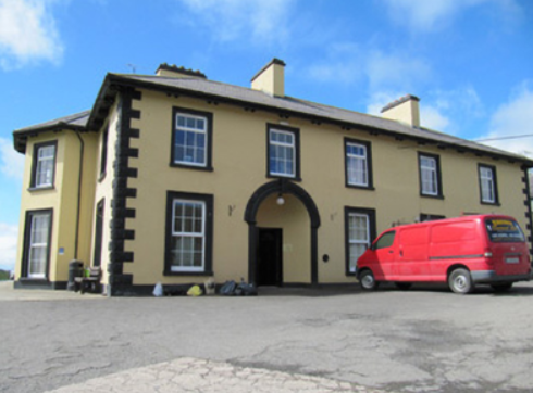
| Tonnagh House | Lewis records Captain C. Dawson as the proprietor of ‘Tanagh’ in the 1830s. Charles Boyle held the property in fee at the time of Griffith’s Valuation when the buildings were valued at £17.5.0. Home of a branch of the Lucas Clements family in 1901 and of Dr Arthur Robert Moore and family in 1911. The National Inventory of Architectural Heritage states that this house has also been an army barracks and seminary (1948) and that it is now used as an outdoor education centre. http://www.tanaghoutdooreducation.com/ |
|
| Milmore/Millmore | A home of the Breakey family in the early 19th century. The Ordnance Survey Field Name Book refers to a gentleman’s seat in the north of the townland of Derry and the house is marked on the first edition 6 inch Ordnance Survey map. Lewis refers to Milmore as the home of ‘the late T. Brunker’. It was occupied by John F. Johnston in the mid-19th century, valued at £22 and held from John Leslie. In 1876, John F. Johnston of Australia owned 143 acres in county Monaghan. Captain Francis Johnston of Milmore House, a veteran of the Peninsular War, died in 1862. A house is still extant at this site. | |
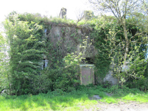
| Corfad | Built in 1828, according to the Ordnance Survey Field Name Book, this two storey house was the residence of ‘Mr McCullough an extensive farmer’. Griffith’s Valuation records James McCullagh as the occupier who held the property which included offices, corn and flax mills, in fee. The buildings were valued at £42. This house is now a ruin. |
|
| Fairfield | Fairfield was the birthplace of the Reverend John Richard Darley in 1799 who became Bishop of Kilmore in 1874. Facing the shore of Inner Lough it is named on the 1st edition 6 inch Ordnance Survey Map (1836). The Field Name Book states that it was the property of Lord Cremorne let to the former proprietor Mr Corry. Griffith’s Valuation records Lord Cremorne as the occupier holding it in fee. The buildings were valued at £23. By the early 20th century this house was no longer in use. The site is now surrounded by a forest. | |
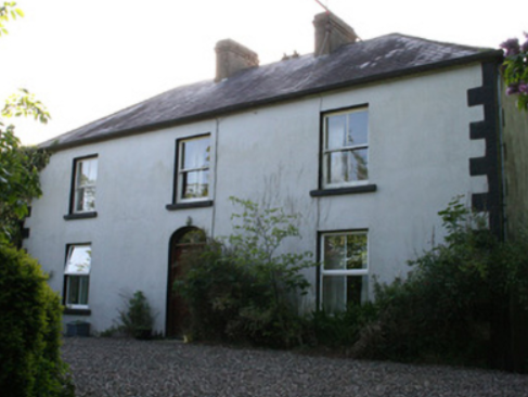
| Fairview | Part of this house, situated on the Verner estate, dates from the late 18th century. Fairview is named on the first edition 6 inch Ordnance Survey map. The building was only valued at £4 in Griffith’s Valuation, when it was occupied by William Lockart. It was considerably added to sometime in the mid-19th century. James Lockart occupied the house in 1910 (Ulster Towns Directory 1910). |
|
| Cumry | Built post 1838, this house was valued at £10 at the time of Griffith’s Valuation and was occupied by John Mullen who held it from Lord Cremorne. A house still exists at this site. | |
| Sallyville | The Ordnance Survey Field Name Book describes Sallyville as ‘a cottage with a garden and very extensive orchard at present much out of order, the residence of Mr Breakey’. It was named on the first edition Ordnance Survey map (1836). Griffith’s Valuation records a steward’s house, offices and lodge in Lisnagalliagh, valued at £10, occupied by David R. Goodlatt and held from William Watson. These buildings were at a different location and by the mid-19th century Sallyville appears to be no longer in existence. | |
| Dartrey House/Dawson's Grove | Dawson Grove, later known as Dartrey House, is marked on the 1st edition 6 inch Ordnance Survey Map (1836). It was built about 1770. Lewis refers to it as a ‘noble mansion’. In 1846, the 3rd Lord Cremorne/1st Earl of Dartrey replaced this house with a large Elizabethan-Revival mansion designed by William Burn. A fire in 1856 destroyed part of the house. At the time of Griffith’s Valuation, circa 1860, the buildings were valued at £105 and still valued at the same in 1906. The family honours became extinct in 1933 following the death of the 3rd Earl and the house was demolished in 1946. |

|
| Bushford | Humphry Thomson was living at Bushford in the mid-18th century. In 1814 Henry Thomson is described as resident at Bushford by Ambrose Leet. 'Robert Thompson' was the occupier holding the property in fee from the 1830s at least. The buildings had a rateable valuation of £5 at the time of Griffith's Valuation. [His son] Colonel Robert Thomson was resident in a new building on the other side of the road in the early 20th century. The new house (H657179) had a rateable valuation of £60 in 1906. His widow, Elizabeth Catherine, and her two daughters lived there in 1911. There were two substantial houses in Clossagh Beg by this time, one inhabited at the time of the censuses, by John Forster and later Joseph Ferris Forster and the other by the Thomsons. Walford's (1918) records Robert George Thomson, only son of Major Frith Thomson and nephew of Lieut. Col. Robert Thomson, died 1911, of Bushford. | |
| Bellamont Forest | A red brick house, designed by Sir Edward Lovett Pearce c 1728 for Thomas Coote, younger son of Richard, Baron of Collooney. Originally known as Coote Hill but its name changed in 1767 to Bellamont Forest following Charles Coote’s elevation to the title Earl of Bellamont (2nd creation). Bellamont Forest was inherited by Charles Johnston Coote in 1800. He was one of the illegitimate children of the Earl. Bellamont Forest was occupied by Richard Coote in the mid-19th century. He held it in fee and the buildings had a rateable valuation of £50.10.0. It was sold by George Coote in 1875 to Edward Smith (K.V. Mulligan), who made a fortune out of coal. Edward Patrick Dorman Smith was the eldest son of Edward Smith and his wife Isabella Cullen and succeeded to Bellamont Forest in 1880. In 1906, Captain E. P. Smith was the occupant of the mansion house with a rateable valuation of £61.5.0. The property remained in the hands of the Smith family until the 1980s when it was purchased by an Australian, John Coote, a descendant of the former owners who spent many years renovating the house. John Coote died in 2012 and the house was sold in 2015 to an American couple. |