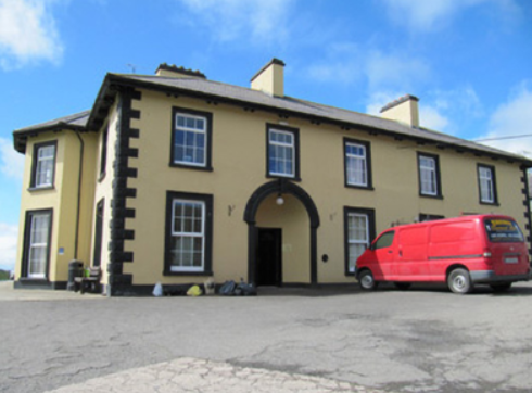
Fairfield
Houses within 5km of this house
Displaying 10 houses.
Houses within 5km of Fairfield
Displaying 10 houses.
| House name | Description | |
|---|---|---|
| Freame Mount | This house was built in 1772 (date stone confirms this) for Charles Mayne, land agent, on the Cremorne estate. According to a website dedicated to the history of the Mayne family, it was named after the second wife of Thomas Dawson, Hannah Freame, granddaughter of William Penn. The house was occupied by William Douglas in the mid-19th century and valued at £24. It was occupied by George John Levis, a bank official, and family in the early 20th century. |

|
| Tonnagh House | Lewis records Captain C. Dawson as the proprietor of ‘Tanagh’ in the 1830s. Charles Boyle held the property in fee at the time of Griffith’s Valuation when the buildings were valued at £17.5.0. Home of a branch of the Lucas Clements family in 1901 and of Dr Arthur Robert Moore and family in 1911. The National Inventory of Architectural Heritage states that this house has also been an army barracks and seminary (1948) and that it is now used as an outdoor education centre. http://www.tanaghoutdooreducation.com/ |
|
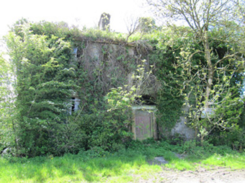
| Corfad | Built in 1828, according to the Ordnance Survey Field Name Book, this two storey house was the residence of ‘Mr McCullough an extensive farmer’. Griffith’s Valuation records James McCullagh as the occupier who held the property which included offices, corn and flax mills, in fee. The buildings were valued at £42. This house is now a ruin. |
|
| Glenburne Cottage | Located on the outskirts of the village of Rockcorry on the Cremorne estate, Samuel Lewis in the 1830s refers to ‘Glenburie Park’ as the residence of C. Stewart Corry. Rebecca Murray was the occupant at the time of Griffith’s Valuation circa 1860 when the buildings were valued at £25. Home of the McFadden family in the early 20th century, no longer extant. | |
| New Park | A house named on the 1st edition 6 inch Ordnance Survey Map (1836), it was occupied by Dacre Hamilton in the 1830s. Home of Thomas Atkinson in the 1850s, valued at £10 and held from Mary Elizabeth and Charlotte O’Brien. Home of the Carleton family in the early 20th century. | |
| Forest View | This house is named on the 1st edition 6 inch Ordnance Survey Map (1836). In the mid-19th century it was occupied by Thomas Dawson and held from Lord Cremorne. The buildings were valued at £12. Partial remains are still visible at this site. | |
| Dartrey House/Dawson's Grove | Dawson Grove, later known as Dartrey House, is marked on the 1st edition 6 inch Ordnance Survey Map (1836). It was built about 1770. Lewis refers to it as a ‘noble mansion’. In 1846, the 3rd Lord Cremorne/1st Earl of Dartrey replaced this house with a large Elizabethan-Revival mansion designed by William Burn. A fire in 1856 destroyed part of the house. At the time of Griffith’s Valuation, circa 1860, the buildings were valued at £105 and still valued at the same in 1906. The family honours became extinct in 1933 following the death of the 3rd Earl and the house was demolished in 1946. |

|
| Dromore Lodge | A house situated on the Cremorne estate, close to Dawson’s Grove and almost on the border with county Cavan. The house is named on the 1st edition 6 inch Ordnance Survey Map (1836). It was occupied in the 1830s by Lieutenant Dawson of the Royal Navy. The building was reduced in size by the time of Griffith’s Valuation when it was rated at £6.10.0. John West Finlay was resident. By the early 20th century it has become the home of the gamekeeper on the Dartrey estate. A building is still located at this site. | |
| Bushford | Humphry Thomson was living at Bushford in the mid-18th century. In 1814 Henry Thomson is described as resident at Bushford by Ambrose Leet. 'Robert Thompson' was the occupier holding the property in fee from the 1830s at least. The buildings had a rateable valuation of £5 at the time of Griffith's Valuation. [His son] Colonel Robert Thomson was resident in a new building on the other side of the road in the early 20th century. The new house (H657179) had a rateable valuation of £60 in 1906. His widow, Elizabeth Catherine, and her two daughters lived there in 1911. There were two substantial houses in Clossagh Beg by this time, one inhabited at the time of the censuses, by John Forster and later Joseph Ferris Forster and the other by the Thomsons. Walford's (1918) records Robert George Thomson, only son of Major Frith Thomson and nephew of Lieut. Col. Robert Thomson, died 1911, of Bushford. | |
| Bellamont Forest | A red brick house, designed by Sir Edward Lovett Pearce c 1728 for Thomas Coote, younger son of Richard, Baron of Collooney. Originally known as Coote Hill but its name changed in 1767 to Bellamont Forest following Charles Coote’s elevation to the title Earl of Bellamont (2nd creation). Bellamont Forest was inherited by Charles Johnston Coote in 1800. He was one of the illegitimate children of the Earl. Bellamont Forest was occupied by Richard Coote in the mid-19th century. He held it in fee and the buildings had a rateable valuation of £50.10.0. It was sold by George Coote in 1875 to Edward Smith (K.V. Mulligan), who made a fortune out of coal. Edward Patrick Dorman Smith was the eldest son of Edward Smith and his wife Isabella Cullen and succeeded to Bellamont Forest in 1880. In 1906, Captain E. P. Smith was the occupant of the mansion house with a rateable valuation of £61.5.0. The property remained in the hands of the Smith family until the 1980s when it was purchased by an Australian, John Coote, a descendant of the former owners who spent many years renovating the house. John Coote died in 2012 and the house was sold in 2015 to an American couple. |