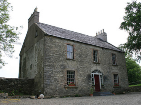
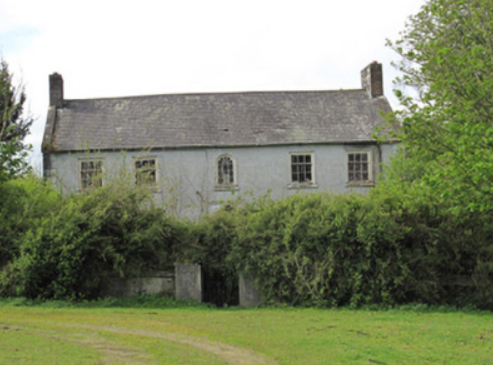
Rockfield (Moysnaght)
Houses within 10km of this house
Displaying 37 houses.
Houses within 10km of Rockfield (Moysnaght)
Displaying 37 houses.
| House name | Description | |
|---|---|---|
| Bessmount Park | The original house ‘Bessmont’, sometimes spelt Bessmount, dates from the early 1800s and is marked and named on the 1st edition 6 inch Ordnance Survey map (1836) with a walled garden to the south. It was the home of a branch of the Montgomery family and was inherited through marriage by the Nixons. In the 1830s it was the residence of A. Nixon Montgomery. In 1840 it was acquired by John Hatchell, High Sheriff of Monaghan in 1843 and his daughter held the house in fee circa 1860. The buildings were valued at £46. The house was elaborately re-modelled in an ornate style possibly to the design of an unknown architect in the late 1860s for the owner William Henderson and became known as Bessmount Park. William Henderson was married to John Hatchell’s daughter Frances Maria Isabella. Mrs Henderson, described as a widow, was living in the house in 1901 and a retired doctor Edward Taylor in 1911. This house continues to be a fine residence. |

|
| Beech Hill | Located on the outskirts of Monaghan town, Beech Hill is named on the 1st edition 6 inch Ordnance Survey Map (1836). The buildings at Beech Hill were valued at £40 in the mid-19th century. William Murray was the occupant. He held the property from Lord Rossmore. Sarah Ker, eldest daughter of André Allen Ker, is described in Burke’s Landed Gentry of Ireland (1904) as resident here. In 1880 she married Fitzjohn Robert Irwin of Kilkeel, county Down. Beech Hill College, a secondary school, is now located on this site. | |
| Castleshane | Castleshane was the home of the Lucas family from the mid-17th century. The original house was described by Lewis as ‘an ancient mansion in a highly enriched and tastefully embellished demesne’. In 1836 it was replaced by a Elizabethan or Jacobean style house built for the Right Honourable Edward Lucas. It was valued at £160 in the mid-19th century and in 1906 when surrounded by 359 acres of untenanted land. Occupied by the Honourable Kathleen Vereker in 1901 and by servants in 1911, this house was burnt on 15 February 1920. Tarquin Blake has documented the remains in his second volume of Abandoned Houses. | |
| Derryvally | An early 19th century house on the Leslie estate, occupied by Thomas McCullagh, held from Emily Leslie and valued at £16 in Griffith’s Valuation. It was located near a Presbyterian complex comprised of two churches and a school. The house continues to be a residence. |
|
| Liscarney House | The home of the Ross family for at least a century and a half. David Ross of Liscarney is mentioned in a deed of 1816. Major Ross is recorded in Liscarney in the Tithe Applotment Book and also by Lewis in the 1830s. In Griffith’s Valuation (circa 1860) James Ross (1819-1893) is mentioned as the occupier holding the property in fee. The buildings were valued at £32. Members of the Ross family continued to reside here well into the 20th century as The Irish Law Times and Solicitors Journal of 1955 records the death of Sharman Crawford Ross, solicitor and estate agent, of Liscarney. |
|
| Lisnaveane House | Home of the Waddell family, it is named on the 1st edition 6 inch Ordnance Survey map (1836) and possibly dates from the late 18th century. It was altered in the 19th century and the yard buildings were extensively extended. At the time of Griffith’s Valuation the buildings were valued at £16. William and Charles Waddell were recorded as the occupants holding the property in fee. Home of Alfred Waddell and family in the early 20th century. |
|
| Clover Hill | Another Waddell home, also named on the 1st edition 6 inch Ordnance Survey map (1836). It was occupied by William Waddell in the mid-19th century and held from Charles Waddell. The value of the buildings was £4.10.0. This house was the home of Alexander Waddell and family in the early 20th century. |
|
| Mill Mount House/Carrickaderry | The house in the village of Clontibret on this site is recorded on the 1st edition 6 inch Ordnance Survey map (1836) as Mill Mount House. It was located on the Blayney (Hope) estate and was the home of the Swanzy family. Lewis refers to the ‘handsome residence’ of A. Swanzy while the Ordnance Survey Field Name Book describes it as a two storey slated house. There was a corn mill nearby. The house was extended and was valued at £24 in the mid-19th century when Humphry Jones, son-in-law of Andrew Swanzy, was the occupant. On the 25 inch map it is named Carrickaderry House. McSkane writes that Carrickaderry was built for the Coote family from Cootehill, Co Roscommon and inherited by a cousin Humphrey Jones. The old house was demolished and a new one built which passed to the McQuade/McQuaid family following the death of Humphrey and his wife. House demolished in the early 1970s. | |
| Rockfield House (Avalreagh) | Rockfield House, a home of a branch of the Swanzy family, is named on the 1st edition 6 inch Ordnance Survey map (1836). Lewis refers to it as the residence of H. Swanzy. Henry Swanzy died in 1843 and his daughter Anne is recorded as the occupant in the 1850s when the house was valued at £14. Miss Kate Green Swanzy was the head of the household living here in 1901 and 1911. There was a name change to Avalreagh House at the beginning of the 20th century. McSkane writes that the Swanzy family lived here from the early 1700s until 1919 when it was bought by Larry Ward. | |
| Coolmain House | The National Inventory of Architectural Heritage dates this house to circa 1790. It belonged to a family called Graham in the 18th century according to a story recorded in the Schools Collection under Coolmain House. It was named on the 1st edition 6 inch Ordnance Survey Map (1836). In the 19th century this property belonged to the Brooke family of Dromavana, county Cavan. Burke’s Landed Gentry of Ireland 1904 records William Brooke of Dromavana, Dublin and Coolmaine House. He was born in 1769 and married Angel daughter of Captain Edward Perry and niece and heiress of Colonel Richard Graham. John Goudy of Coolmain House is listed in Lewis’ ‘Topographical Dictionary’ published 1837 for the parish of Tehallan but his name is spelt Gondy in the list of subscribers. John Goudy is recorded in Griffith’s Valuation as resident holding the property from the Reverend Edward P. Brooke and others. James Gondy Lewers of Coolmain House died in November 1885 (The Northern Standard, 7 November 1885). This house was occupied by James H. Pollock in 1911 and is still a residence. | |
| Tully House | An early two storey 19th century house, marked on the 1st edition 6 inch Ordnance Survey map (1836) with a later extension. This was the home of the Hall family located on the outskirts of Monaghan town. Pery Hall of Tully House was the father of the Reverend Richard Augustus Hall who married Mary Henry of Mourne Abbey, county Down in 1849. At the time of Griffith’s Valuation the house was valued at £14 and occupied by John S. Stuart. Mary, widow of the Reverend Hall, was the occupant in the early 20th century. This house continues to be a residence. The Halls also had a house in the town of Monaghan, townland of Mullaghmonaghan, close to the County Infirmary known as Rowantree. |

|
| Greenmount | Marked on the 1st edition 6 inch Ordnance Survey map (1836) this house was described as a thatched 2 storey house with an orchard and nursery. The grounds were planted all-round the house. It was extended after Griffith’s Valuation and was the home of the agents for the Castleshane estate. At the beginning of the 20th century it was occupied by William Martin, land agent. In the 1920s Martin purchased Greenmount and following the death of his sister in 1949 it was sold to Albert Noble. |
|
| Bowelk | This house is not marked on the first edition 6 inch Ordnance Survey map but is recorded in Griffith’s Valuation when it was occupied by William H. Jackson, a member of a family who had extensive linen manufacturing and corn milling interests in the neighbourhood. It remained in the possession of the Jackson family until the 1920s. Advertised for sale in the Sunday Times on 5 June 2011 after renovation. |
|
| Fairview | Part of this house, situated on the Verner estate, dates from the late 18th century. Fairview is named on the first edition 6 inch Ordnance Survey map. The building was only valued at £4 in Griffith’s Valuation, when it was occupied by William Lockart. It was considerably added to sometime in the mid-19th century. James Lockart occupied the house in 1910 (Ulster Towns Directory 1910). |
|
| Cumry | Built post 1838, this house was valued at £10 at the time of Griffith’s Valuation and was occupied by John Mullen who held it from Lord Cremorne. A house still exists at this site. | |
| Cumry Lodge | Marked on the first edition 6 inch Ordnance Survey map, this house with a rateable valuation of £12, was occupied by the Reverend John Morell in the mid-19th century and by the Reverend James Morell in 1910 (Ulster Towns Directory 1910). The Morells were Presbyterian ministers in Ballybay, see http://treasureyourexceptions.com/morell.html The property was held from Lord Cremorne. |
|
| Creeve House/Creevelands | Built in the early 19th century by the Jackson family in the middle of their linen manufacturing enterprise in this townland. Marked on the first edition 6 inch Ordnance Survey map as Creeve House but later known as Creevelands. Lewis records the occupant as S. Cunningham. The rental of 70 acres at Creeve, the estate of Arthur Montgomery was for sale in the Encumbered Estates Court in 1858. The petitioners were Margaret Cunningham and her children. By the time of Griffith’s Valuation Robert Murdock was the occupier of the house, holding the property from Edward Lucas. This house remains a residence with its extensive and well maintained outbuildings. |

|
| Dunraymond | This house with extensive outbuildings and walled garden is named on the 1st edition 6 inch Ordnance Survey Map (1836). Documents in PRONI (D991/1/A/3) record the interest of the Bartley family of nearby Bartley’s Grove in Dunraymond in the early 19th century. Described in the Ordnance Survey Field Name Book as having ‘been greatly improved of late both as to additions being made to the buildings and the formation of plantings’. By the time of Griffith’s Valuation David Ross was resident. He held the property from Newell Atkinson. The buildings were valued at £34. A large complex of farm buildings is now located at this site. | |
| Rockmullan House | Marked on the first edition Ordnance Survey Map (1836). In the mid-19th century occupied by the Rev James J. Rowley and held from Thomas T. Rowley, when the rateable valuation was £12. The home of the Lavelles in the 20th century. | |
| Dromore House | Dromore House is named on the 1st edition 6 inch Ordnance Survey map (1836) with a circular drive to the front and a walled garden to the rear. It was the home of C. Hawkshaw in the 1830s. Located on the Hatchell estate it was occupied by James Wade at the time of Griffith’s Valuation and valued at £14. The home of the Smyth family in the early 20th century, this house is no longer in existence. | |
| Sallymount | Sallymount facing a plantation is named on the 1st edition 6 inch Ordnance Survey map (1836). In the 1830s it was the home of T. Robinson. At the time of Griffith’s Valuation the buildings were valued at £8 and John Woods was the occupant, holding the property from John Maxwell, whose estate was at that time being administered by the Court of Chancery. Home of the Assistant County Surveyor James Smith in 1911. He held the house from John McMahon. A building is still located at this site. | |
| Rossmore Park | Situated on an elevated site the original house was known as Cortolvin Hills. This is the name that appears on the 1st edition 6 inch Ordnance Survey map (1836) for the house. It was the home of the Westenra family, Barons Rossmore. In 1824, Richard Morrison produced plans to rebuild the house and by the end of the decade William Morrison had taken over from his father. Collins writes that the old house appears to have become the servants’ wing and that the new house had a Jacobean facade. Lewis refers to Rossmore Park as ‘a handsome mansion in the Elizabethan style’. It was remodelled in the late 1850s to the design of W.H. Lynn, after which, Bence Jones writes, ‘the combined ranges boasted of at least 117 windows, of 53 different shapes and sizes’. The buildings were valued at £250 in Griffith’s Valuation and in 1906. During World War II the 6th Lord Rossmore moved from Rossmore Park to Camla House due to pervasive dry rot in the house. It was unroofed after the war and the ruin was demolished in the mid-1970s. | |
| Will Ville | The National Inventory of Architectural Heritage dates this building early 18th century. It was located on the estate of Lord Rossmore and is named on the 1st edition 6 inch Ordnance Survey map (1836). Valued at £10 and occupied by Robert Wilson at the time of Griffith’s Valuation. Still occupied by Robert Wilson, farmer, in the early 20th century. This house has been unoccupied for some time. |
|
| Cortolvin | This house was built between the first Ordnance Survey of the 1830s and the surveying for Griffith’s Valuation in the 1850s. It is marked on the 25 inch map (surveyed 1908) and named Cortolvin. In Griffith’s Valuation it was occupied by William A. Hunter and held from Lord Rossmore. It was valued at £16. This house is still extant. | |
| Tirkeenan House | This house is named on the 1st edition 6 inch Ordnance Survey map (1836). It was located on the Rossmore estate and very close to the town of Monaghan. It was occupied by John M’Dowell circa 1860 when the buildings were valued at £32. A third storey was added to this house in the 20th century. |

|
| Corlat House | A house named Cook Mount was located in Corlat on the first Ordnance Survey Map (circa 1836). Corlat House was built in the mid-19th century on a nearby site, valued at £20 and occupied by the Reverend James Bleakley, who held it from William Murray. In the early 20th century William McWilliam, Clerk of the Crown and Peace lived at Corlat House. It is no longer extant. | |
| Harry Mount | The Ordnance Survey Field Name Book describes this house as a small, thatched, one storey farm house, with a garden and orchard. The house was on the Lucas estate and is named on the 1st edition 6 inch Ordnance Survey map (1836). The buildings at Harry Mount, which included a flax mill, were valued at £12.10 shillings in Griffith’s Valuation when the house was occupied by Charles Carson. The Carson family were still resident at the beginning of the 20th century. McSkane writes that this was a thatched building which remained thatched up to the 1950s. Built for Henry Swanzy circa 1816 and sold to James Carson from Ballybay in 1839. | |
| Lakelands (Clontibret) | A building was located at this site on the 1st edition 6 inch Ordnance Survey map (1836). It was later extended. At the time of Griffith’s Valuation the buildings were valued at £11. It appears to have functioned as a priests’ house as it was held by the representatives of the Reverend James Duffy from Edward Lucas. In the early 1901 the Reverend Thomas Duffy, a Roman Catholic priest, was head of the household and in 1911 the Reverend Thomas O’Doherty. | |
| Corratanty | An early 19th century house named on the 1st edition 6 inch Ordnance Survey map (1836) and located on the Templetown estate. A model farm was located here by the mid-19th century when the house was occupied by Andrew Hunter and the buildings valued at £23. David K. Hunter, farmer, was the occupier in the early 20th century. This house is still the centre of a working farm |
|
| Craig's Castle | This five bay two storied house was built on the Leslie estate in the late 18th century. Occupied by John Carlisle and valued at £14 at the time of Griffith’s Valuation. This house is still extant and known as Hillcrest. |
|
| Annaneese | Annaneese house is marked on the first edition 6 inch Ordnance Survey map and named on the 25 inch one. At the time of Griffith’s Valuation it was occupied by John McClatchey and held from Emily Leslie. This house is no longer extant. | |
| Annaneese | Annaneese house is marked on the first edition 6 inch Ordnance Survey map and named on the 25 inch one. At the time of Griffith’s Valuation it was occupied by John McClatchey and held from Emily Leslie. This house is no longer extant. | |
| Ballybay House | Ballybay House, also known as The Castle, was the home of the Leslie family, designed by John Keane and built in 1830. It was located a short distance from the town. It was described by Lewis in the 1830s as a ‘handsome and beautiful mansion situated on the border of a lake and backed by some extensive plantations’. In the mid-19th century its rateable valuation was £120 and it was the home of Emily Leslie. It later became the home of Edward John Henry Leslie (1890-1966), British Ambassador to Rome. The house was burnt down in 1921. The walled garden and some outbuildings remain. | |
| Ballybay House | Ballybay House, also known as The Castle, was the home of the Leslie family, designed by John Keane and built in 1830. It was located a short distance from the town. It was described by Lewis in the 1830s as a ‘handsome and beautiful mansion situated on the border of a lake and backed by some extensive plantations’. In the mid-19th century its rateable valuation was £120 and it was the home of Emily Leslie. In 1894 it was noted by Slater as the residence of Robert Charles Leslie. By 1906 its valuation had risen to £140. It later became the home of Edward John Henry Leslie (1890-1966), British Ambassador to Rome. The house was burnt down in 1921. The walled garden and some outbuildings remain. | |
| Ashvale | This house was built in the mid-19th century, after the surveying for the first edition 6 inch Ordnance Survey map and before Griffith’s Valuation, when it was valued at £10 and occupied by James Bradshaw who held it from Robert Ellis. A building is still located at this site. | |
| Agheralane | Both Lewis and Griffith’s Valuation record Agheralane as the residence of Thomas Lucas. It was valued at £28 and held from Joseph Griffith. Occupied by John and Emily Adams at the beginning of the 20th century. The buildings were laid out in a square. | |
| Woodview | Situated on the Lucas estate, this house was not built at the time of Griffith’s Valuation (circa 1860) as there is no house in the townland of more than £2.10.0. valuation. The National Inventory of Architectural Heritage records that it is believed to have been built as a house for the agent to the Castleshane estate. |