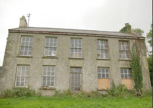
Finn Lodge
Houses within 15km of this house
Displaying 39 houses.
Houses within 15km of Finn Lodge
Displaying 39 houses.
| House name | Description | |
|---|---|---|
| Greenhills (Raphoe) | William Fenwick held this property in fee at the time of Griffiths Valuation in the 1850s, when it was valued at £55. The National Inventory of Architectural Heritage suggests that it dates from the later eighteenth century though altered in the 1870s. It was originally associated with the Nesbit family into which William Fenwick married. In 1906 it was owned by Philip and Charles Fenwick and valued at £27. The house is still extant though not in good repair. |
|
| Castlefin House | At the time of Griffiths Valuation in the 1850s, Nicholas Simms was leasing this property from Margaret E. Rogan when it was valued at £32. It is labelled Castlefin House on all editions of the Ordnance Survey maps. The site is now occupied by the modern RC church. | |
| Demesne (Raphoe South) | William Baird was leasing this property from the representatives of Connelly M.L. Leckey at the time of Griffith's Valuation in the 1860s, when it was valued at £10. The original building is not extant. | |
| Mullanboy | William Baird was leasing this property from the representatives of Connelly M.L. Leckey at the time of Griffith's Valuation in the 1860s, when it was valued at £30 with a substantial mill complex adjoining. Elements of the mill complex are still extant. | |
| Guystown (Raphoe) | At the time of Griffiths Valuation in the 1850s, Benjamin Humfrey was leasing this property from the Erne estate, when it was valued at £7. It was subsequently enlarged and is labelled Guystown on all editions of the Ordnance Survey map. The National Inventory of Architectural Heritage suggests it was originally built c.1720. It is still extant and occupied. | |
| Dromore (Raphoe North) | At the time of Griffiths Valuation in the 1850s, Jane Stephenson was leasing this property from the Earl of Erne's estate when it was valued at £10. | |
| Toberoneill | At the time of Griffiths Valuation in the 1850s, Joseph Henderson was leasing this property from the Earl of Erne's estate when it was valued at £12. The National Inventory of Architectural Heritage suggests the large scale outbuildings date from c.1860. There is an altered house at the site. |
|
| Shannon Middle | James Henderson was leasing this property from the Earl of Erne's estate at the time of Griffiths Valuation in the 1850s, when it was valued at £11. It is labelled Shannon Middle on all editions of the Ordnance Survey maps. Substantial farm buildings exist at the site now. | |
| Shannon (Raphoe North) | Samuel Gourley was leasing this property from the Erne estate at the time of Griffiths Valuation, when it was valued at £10. It is labelled Shannon on all editions of the Ordnance Survey maps. A farm is extant at the site. | |
| Killindarragh [Nassau Hall] | At the time of Griffiths Valuation, in the 1850s, Mrs. Angel I. Stewart was leasing this property from the Earl of Erne's estate when it was valued at £20. It is labelled Nassau Hall on the 1st edition Ordnance Survey map of the late 1830s but as Killindarragh on subsequent editions. It is still extant. | |
| Cavanacor | This property was held in fee by Benjamin [Humfrey] at the time of Griffiths Valuation, when it was valued at £33. Wilson referred to it as the seat of "Mrs Kays" in 1786. The National Inventory of Architectural Heritage suggests it was built about 177-, possibly incorporating part of a seventeenth century house. It is still extant and occupied. |
|
| Broomfield (Raphoe North) | John Humphreys was leasing this property from Robert Keys at the time of Griffiths Valuation, when it was valued at £20. It is labelled Broomfield on all editions of the Ordnance Survey maps. A house is still extant at this site. A second house, labelled Cumberland Lodge [C310024], is shown in this townland on the 25-inch Ordnance Survey map of the early 20th century. A house is still extant at this site. | |
| Clonleigh (Raphoe North) | Reverend William Knox held this property in fee at the time of Griffiths Valuation in the 1850s when it was valued at £70. In 1906 it was the property of William Knox and valued at £73. It is no longer extant. | |
| Longvale | At the time of Griffiths Valuation in the 1850s Letitia Keys was leasing this property from the Knox estate when it was valued at £14. On the 1st and 25-inch edition Ordnance Survey maps it is labelled Longvale. The National Inventory of Architectural Heritage suggests that this house, now known as Hall Green Farm, mostly dates from the mid eighteenth century though possibly incorporating fabric from the earlier house on the site, reputedly built by Thomas Keyes in the early seventeenth century. |

|
| Port Hall (Raphoe North) | James Clarke was leasing this property from the Dogherty estate at the time of Griffiths Valuation in the 1850s, when it was valued at £35. The National Inventory of Architectural Heritage suggests it was built in the 1740s for John Vaughan and classifies it as a building of national importance. It is still extant and occupied. |
|
| Murlough (Raphoe North) | At the time of Griffiths Valuation in the 1850s, James Houston was leasing this property from the Earl of Erne's estate when it was valued at £10. On the 25-inch edition Ordnance Survey map the house on the site is labelled Manse. The National Inventory of Architectural Heritage suggests it was enlarged in the later nineteenth century, possibly when it came into use as the manse. It is still extant and occupied. |
|
| Ballyduff House (Raphoe North) | At the time of Griffiths Valuation, William Clarke was leasing this property from the Knox estate when it was valued at £17. It is still extant and occupied. |
|
| Croghan House (Raphoe North) | At the time of Griffiths Valuation, James Cochran was leasing this property from Joseph Scott when it was valued at £55. It was constructed after the publication of the 1st edition Ordnance Survey map of the 1830s and is labelled Croghan House on later editions. It is still extant and occupied. |
|
| Belmount (Raphoe North) | Robert Lowry was leasing this property from William Clarke's estate at the time of Grffiths Valuation in the 1850s, when it was valued at £25. The property was extant until the 1990s when modern housing was constructed on the site. | |
| Ardvarnock Lower | ||
| Beltany | David Wilson was leasing this property from the Ecclesiastical Commissioners estate at the time of Griffiths Valuation in the 1850s, when it was valued at £17. It is now a ruin. | |
| Magherycallaghan House | James McCurdy was leasing this property from the Macky estate at the time of Griffiths Valuation in the 1850s when it was valued at £18. A mill complex was located in the area also. The National Inventory of Architectural Heritage suggests the house was built in the late eighteenth century. Later in the nineteenth century it was associated with the Cunningham family. It is still extant and occupied. |
|
| Horse Hill House/Knockagarran House (Raphoe South) | The Hone estate was leasing this property to the representatives of John Spear at the time of Griffiths Valuation in the 1850s, when it was valued at £15. It is labelled Knockagarran on the 1st edition Ordnance Survey map but as Horse Hill House on the 25-inch edition of the early twentieth century. It is still extant. | |
| Mount Hall (Raphoe South) | Reverend William Young held this property in fee at the time of Griffiths Valuation in the 1850 when it was valued at £28. The National Inventory of Architectural Heritage suggests it remained in the Young family until the 1890s. The buildings are now ruinous but a foundation stone, dated 1840, survives. |
|
| Drumboe Castle | A castle and manor existed at Drumboe since the early seventeenth century. At the time of Griffiths Valuation in the 1850s, Drumboe was the seat of Sir Edmund Hayes, when it was valued at £60. It remained in the ownership of the Hayes family until the early twentieth century. In 1906 it was the property of Sir E.F. Hayes and valued at £33. It and the demesne were acquired by the Forestry service in the 1940s. The ruins of the estate buildings are still visible in the extensive woodlands and amenity areas at the site. |
|
| Summerhill (Raphoe South) | James Johnston was leasing this property from the Conyngham estate at the time of Griffiths Valuaiton in the 1850s, when it was valued at £20. It is now a ruin. | |
| Woodlands (Raphoe South) | James Johnston was leasing this property from Samuel Calhoun, at the time of Griffiths Valuation in the 1850s, when it was valued at £40. The National Inventory of Architectural Heritage suggests the original buildings at the Woodlands site were constructed in the early years of the nineteenth century but modified later. They are now ruinous. |
|
| Killygordon House | Joseph Johnston was leasing this property from James Johnston at the time of Griffiths Valuation in the 1850s, when it was valued at £20. The site is labelled Killygordan Demesne or Weddingtown, on the first edition Ordnance Survey map of the 1830s. It is labelled Killygordan House on subsequent editions. The National Inventory of Architectural Heritage suggests the original house was built in the later eighteenth century but subsequently modified. It was associated with the Mansfield family originally but with the Johnstons by the latter half of the nineteenth century. It is still extant and occupied. |
|
| Kilcaddan House | William Walker was leasing this property from the Diocese of Derry and Raphoe at the time of Griffiths Valuation, when it was valued at £16. An adjacent mill complex was valued at £18. The National Inventory of Architectural Heritage suggests the current house was built in the 1860s, possibly on the site of an earlier house. |
|
| Edenmore House | John Cochrane was holding this property in fee at the time of Griffiths Valuation when it was valued at £28. In 1906 it was also owned by John Cochrane and valued at £26. The National Inventory of Architectural Heritage suggests it was built c.1790 and offers a detailed outline of its occupancy. It is still extant. |
|
| Monellan | A house described as "unfinished" was held in fee at Monellan by Robert Delap at the time of Griffiths Valuation in the 1850s. The buildings were valued at £45. A house is shown at this location on the 1st edition Ordnance Survey map of the 1830s but has been greatly extended by the early twentieth century. In 1906 it was owned by James B. Delap and valued at £56. It appears to have been demolished by the mid-twentieth century and the site is now occupied by forestry. | |
| Killygordon A | At the time of Griffiths Valuation in the 1850s, Alex Humphrey was leasing this property from the Mansfield estate when it was valued at almost £15. | |
| Cavan (Raphoe) | The representatives of John Wilson were leasing this property from Alexander Stewart's estate at the time of Griffiths Valuation, when it was valued at almost £13. A house and substantial farm are still extant at the site. | |
| Tyrcallan/The Nursery (Raphoe) | At the time of Griffiths Valuation in the 1850s, Reverend William Stewart was leasing this property from the Conyngham estate when it was valued at £18. It is labelled as The Nursery on the 1st edition Ordnance Survey map but as Tyrcallan on the later 25-inch edition. In 1837 Lewis referred to it as Tyrcallan, the seat of H. Steevens and as having an observatory on the grounds. In 1906 it was recorded as part of the estate of the Marquis of Conyngham with a valuation of over £10. The National Inventory of Architectural Heritage suggests it was originally built as a hunting lodge. It is now derelict. |
|
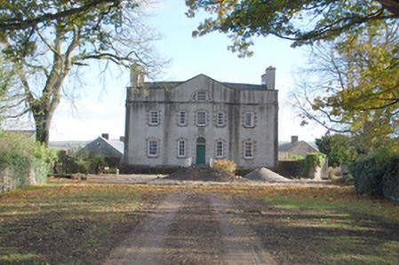
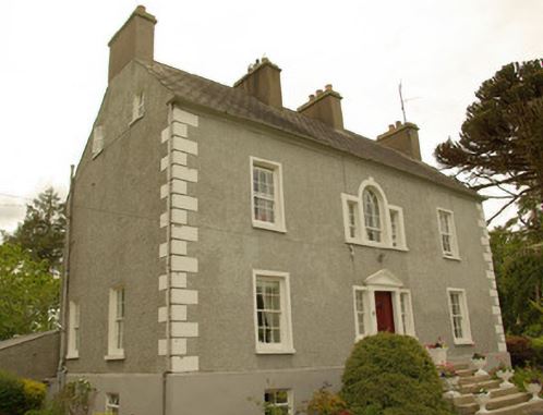
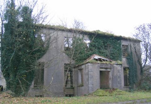
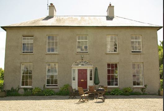
| Convoy House [Greenfield] | Robert Montgomery held this property in fee at the time of Griffiths Valuation when it was valued at £35. In 1837 Lewis had also referred to it as the seat of R. Montgomery. In 1896 it was owned Canon Boyton and valued at £33. The National Inventory of Architectural Heritage suggests it was built in the early years of the 19th century and provides a detailed description of its occupancy. It is still extant and occupied. |
![Photo of Convoy House [Greenfield]](https://landedestates.ie/storage/img/orig/3296.jpg)
|
| Corcam | Henry Stewart held this property in fee at the time of Griffiths Valuation in the 1850s, when it was valued at £22. It is labelled Corcam on both the 25-inch and last edition 6-inch Ordnance Survey maps but is not extant now. | |
| Rockfield House (Raphoe South) | John Johnston was leasing this property from the Conyngham estate at the time of Griffiths Valuation in the 1850s, whe it was valued at £20, with an adjacent mill valued at £14. The current house appears to have been built after the publication of the 1st edition Ordnance Survey map in the 1830s. The National Inventory of Architectural heritage provides a detailed chronology of its occupation by the Johnston family. |
|
| Kilmainham - The Cottage/Heath Lodge | Ambrose Leet records Kill, Mount Nugent, as the residence of George Lenauze. Kill House, located on the estate of the Bishop of Kilmore, is named on the first edition 6 inch Ordnance Survey map (publ. 1837). At this time there were laid out gardens and extensive plantations within the demesne grounds. The buildings at Kill House are reduced in size on the later 25 inch map. In the 1850s, Garrett Keogh was the occupier holding the property valued at £5 from John Orpen. This house is no longer extant. | |
| Laurel Bank/Holly Bank | This house, originally known as Laurel Bank, is named on the first edition six inch Ordnance Survey map (publ. 1837). It is shown in a demesne which included an old bleach mill and a corn mill and kiln. It is believed to have been built by a mill owner in the 18th century. Griffith’s Valuation records William Norton as the occupant holding the property valued at £8.10.0. from the Earl of Gosford. The house is called Holly Bank on the 25 inch map. Altered and added to in the 20th century it continues to be a residence. |