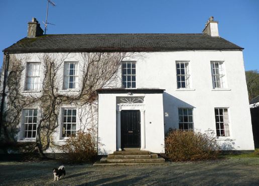
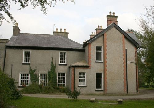
Treantagh (Raphoe North)
Houses within 10km of this house
Displaying 29 houses.
Houses within 10km of Treantagh (Raphoe North)
Displaying 29 houses.
| House name | Description | |
|---|---|---|
| Bohullion | Several properties at this location were being leased from Lord Templemore’s estate by members of the Leathem family at the time of Griffith’s Valuation, in the 1850s. Samuel Leathem senor occupied a house which was valued at £14 10s. Samuel Leathem junior occupied a house and substantial mill and distillery complex. The National Inventory of Architectural Heritage indicates that the house at the site is now called Beech Park and dates from c.1845. Elements of the industrial complex are also still extant. | |
| Raymoghy | William Montgomery was leasing this property from James Law at the time of Griffiths Valuation in the 1850s, when it was valued at £10. The site is now occupied by farm buildings. | |
| Guystown (Raphoe) | At the time of Griffiths Valuation in the 1850s, Benjamin Humfrey was leasing this property from the Erne estate, when it was valued at £7. It was subsequently enlarged and is labelled Guystown on all editions of the Ordnance Survey map. The National Inventory of Architectural Heritage suggests it was originally built c.1720. It is still extant and occupied. | |
| Dromore (Raphoe North) | At the time of Griffiths Valuation in the 1850s, Jane Stephenson was leasing this property from the Earl of Erne's estate when it was valued at £10. | |
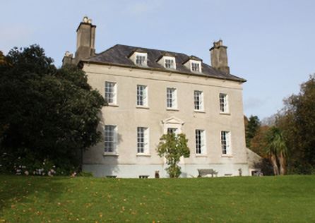
| Cavanacor | This property was held in fee by Benjamin [Humfrey] at the time of Griffiths Valuation, when it was valued at £33. Wilson referred to it as the seat of "Mrs Kays" in 1786. The National Inventory of Architectural Heritage suggests it was built about 177-, possibly incorporating part of a seventeenth century house. It is still extant and occupied. |
|
| Broomfield (Raphoe North) | John Humphreys was leasing this property from Robert Keys at the time of Griffiths Valuation, when it was valued at £20. It is labelled Broomfield on all editions of the Ordnance Survey maps. A house is still extant at this site. A second house, labelled Cumberland Lodge [C310024], is shown in this townland on the 25-inch Ordnance Survey map of the early 20th century. A house is still extant at this site. | |
| Clonleigh (Raphoe North) | Reverend William Knox held this property in fee at the time of Griffiths Valuation in the 1850s when it was valued at £70. In 1906 it was the property of William Knox and valued at £73. It is no longer extant. | |
| Longvale | At the time of Griffiths Valuation in the 1850s Letitia Keys was leasing this property from the Knox estate when it was valued at £14. On the 1st and 25-inch edition Ordnance Survey maps it is labelled Longvale. The National Inventory of Architectural Heritage suggests that this house, now known as Hall Green Farm, mostly dates from the mid eighteenth century though possibly incorporating fabric from the earlier house on the site, reputedly built by Thomas Keyes in the early seventeenth century. |

|
| Port Hall (Raphoe North) | James Clarke was leasing this property from the Dogherty estate at the time of Griffiths Valuation in the 1850s, when it was valued at £35. The National Inventory of Architectural Heritage suggests it was built in the 1740s for John Vaughan and classifies it as a building of national importance. It is still extant and occupied. |
|
| Murlough (Raphoe North) | At the time of Griffiths Valuation in the 1850s, James Houston was leasing this property from the Earl of Erne's estate when it was valued at £10. On the 25-inch edition Ordnance Survey map the house on the site is labelled Manse. The National Inventory of Architectural Heritage suggests it was enlarged in the later nineteenth century, possibly when it came into use as the manse. It is still extant and occupied. |
|
| Pluck | James B. Marshall was leasing this property from the Hayes estate at the time of Griffiths Valuation in the 1850s, when it was valued at £18. It adjoined a mill complex. The site is occupied by modern buildings now. | |
| Altaghaderry | Alexander Maxwell was leasing this property from the estate of Robert McClintock at the time of Griffith’s Valuation, in the 1850s, when it was valued at £10. Modern buildings are visible at the site now. | |
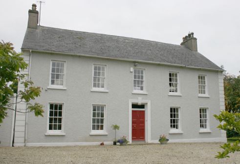
| Castruse House | William Cochrane was leasing this property from Robert Bateson at the time of Griffiths Valuation in the 1860s when it was valued at £12. It is labelled Castruse Huose on the 25-inch map of the early 20th century. In the 1870s John Motherwell's address is given as Castruse. The National Inventory of Architectural Heritage suggests it was built in the last years of the 18th century on the site of an earlier house. It is still extant and occupied. |
|
| Ballyboe House | This property was held in fee by the Bateson estate at the time of Griffiths Valuation in the 1850s when it was valued at £27. It is labelled Ballyboe House on the 25-inch Ordnance Survey map of the early 20th century. It is still extant. | |
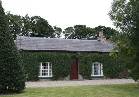
| Bogay House (Raphoe North) | Reverend Edward Bowen held this property in freehold at the time of Griffith's Valuation in the 1850s when it was valued at £35. Local sources suggest it was a hunting lodge built by the Abercorn estate. It is still extant and occupied. |
|
| Colehill | Reverend Hugh Norman was leasing this property from the Earl of Wicklow's estate at the time of Griffith's Valuation in the 1850s when it was valued at £12. It is labelled Colehill on the 1st edition map of the 1830s but as Allsaints Rectory on subsequent Ordnance Survey maps. It is still extant. | |
| Crossroads (Raphoe North) | William Lockhart was leasing this property from the Earl of Wicklow's estate at the time of Griffith's Valuation in the 1850s when it was valued at £10. It has the label Crossroads on the 25-inch and later 6-inch edition Ordnance Survey maps. The National Inventory of Architectural Heritage suggests the house at the site was built later in the 19th century but it appears likely that an earlier house existed there. |
|
| Castleforward | John Ferguson was leasing this property from the Earl of Wicklow's estate at the time of Griffith's Valuation in the 1850s when it was valued at £35. In 1837, Lewis had referred to it as the property of the Earl of Wicklow, then occupied by W. Marshall. Though it survived well into the 20th century, Castleforward is now a ruin. | |
| Ballyhasky House | Reverend William Scott was leasing this property from the Earl of Wicklow's estate at the time of Griffith's Valuation in the 1850s when it was valued at £15. It is still extant and occupied. |
|
| Ballyhasky Middle | Patrick Glacken was leasing this property from the Earl of Wicklow's estate at the time of Griffith's Valuation in the 1850s when it was valued at £10. It is still extant and occupied. |
|
| Monglass | Caldwell Motherwell was leasing this property from the Earl of Wicklow's estate at the time of Griffith's Valuation in the 1850s when it was valued at £13. The house at the site now is of late 19th century construction. | |
| Drumbarnet | Samuel Chambers was leasing this property from the Earl of Wicklow's estate at the time of Griffith's Valuation in the 1850s when it was valued at £18. In 1906 it had the same valuation and was owned by William Glenn. It is still extant. The National Inventory of Architectural Heritages suggests that it was extensively altered around 1911 with an extension added to the front at that time. |
|
| Cloon (Raphoe) | Robert McFarlane was leasing this property from Anne Law at the time of Griffiths Valuation in the 1850s, when it was valued at £16. Labelled as Cloon on all editions of the Ordnance Survey maps. Farm building occupy the site of the original house now. | |
| Moyle Moss | Henry Thompson was leasing this property from John S. Law at the time of Griffiths Valuation in the 1850s, when it was valued at £11. Labelled Moyle Moss on all editions of Ordnance Survey. The National Inventory of Architectural Heritage suggests the house at the site now is not the original but outbuildings date from the mid 19th century. |
|
| Heath Hill (Raphoe) | Francis Long was leasing this property from John S. Law at the time of Griffiths Valuation in the 1850s, when it was valued at £16. A house labelled Heath Hill is visible at this site on the 25-inch Ordnance Survey map of the early 20th century. Buildings are still extant at the site. | |
| Castle (Newtowncunningham) | Henry McCoy was leasing this property from John S. Law at the time of Griffiths Valuation in the 1850s, when it was valued at £17 10s. The lease also included two flaxmills. This property is labelled Castle on all editions of the Ordnance Survey maps. Campbell records that in the 1790s, the Castle in Newtowncunningham was the home of Lady Hamilton, widow of Sir Henry Hamilton and that the McFarland family were the last occupants. | |
| Mason Lodge (Raphoe) | William McCormack was leasing this property from John S. Law at the time of Griffiths Valuation in the 1850s, when it was valued at £10. McCormack was one of the investors associated with the Lough Swilly land reclamation works in the mid 1840s. This property is now the centre of a large farm. | |
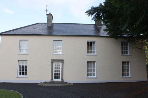
| Dunmore House (Raphoe North) | This property was held in fee by Robert McClintock at the time of Griffiths Valuation in the 1850s, when it was valued at £38. In 1837 Lewis referred to it as the seat of R. McClintock. By 1906 it was owned by his representatives with the same valuation. The National Inventory of Architectural Heritage suggests it was built in the 1740s with extensions in the 1820s and 1840s. It is still extant and occupied. |
|
| Sallybrook | James Marshall was leasing this property from the Earl of Wicklow's estate at the time of Griffiths Valuation in the 1850s. It was then valued at £15. In 1906 it was the property of Samuel Marshall and valued at £12. The site appears to be occupied by farm buildings now. |